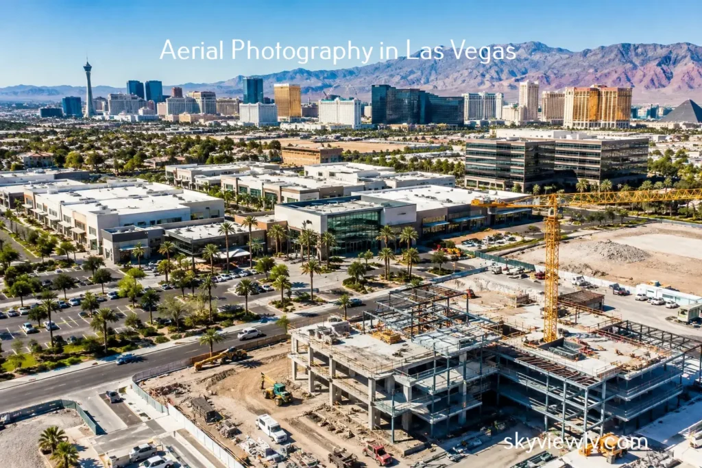
Aerial listing preparation starts well before a drone takes off. For a luxury home overlooking the Strip, a commercial site near a major corridor, or vacant land on the edge of the Las Vegas Valley, the strongest aerial images are planned around one question: what does a buyer, tenant, or investor need to understand at a glance?
Aerial media can show the context conventional listing photography cannot. It can establish proximity to amenities, reveal lot orientation, frame access points, document surrounding development, and give a property the visual authority needed to stand out online. But those results depend on more than a beautiful sunset and a high-resolution camera. They require a prepared site, a clear marketing objective, and a flight plan built around both the property and the local airspace.
Why Aerial Listing Preparation Changes the Final Product
Drone photography is not simply an elevated version of ground photography. The viewpoint changes what the audience notices first. From above, a buyer may see a home’s pool, outdoor living areas, neighboring rooftops, road access, mountain views, or how close a commercial building sits to a freeway interchange. Those details can strengthen a listing, but they can also expose distractions that are easy to overlook at street level.
Preparation gives the photographer control over that story. An unprepared exterior may include open garage doors, trash bins, parked vehicles, construction materials, dead landscaping, or an uncovered pool, all of which can make a premium property feel unfinished. On a land or commercial assignment, cluttered staging areas, unsecured equipment, and poorly timed deliveries can make an otherwise valuable site appear disorganized.
The goal is not to make a property look like something it is not. It is to present the asset clearly, accurately, and at its best. That distinction matters in real estate marketing, where a compelling image should generate qualified interest rather than create unrealistic expectations.
Start With the Listing’s Real Selling Point
Before scheduling an aerial session, identify the one or two features that justify an elevated perspective. Every property has different priorities.
For a residential listing, the aerial story may be the relationship between the home and its surroundings. A rooftop deck with Strip views, a large corner lot, a backyard built for entertaining, or direct access to trails can be more persuasive from the air than from the driveway. For a commercial property, the priority may be building visibility, parking capacity, ingress and egress, signage exposure, or location near major employment centers.
Vacant land requires even more strategic planning. Buyers often need to see parcel boundaries in relation to roads, neighboring uses, terrain, utilities, and nearby growth. Aerial imagery helps turn an abstract acreage figure into something tangible. It can also support investor presentations by showing how a site fits into the broader development pattern.
Share the listing details before the shoot. Aerial professionals can plan more effectively when they know the target buyer, the property’s strongest features, any views worth protecting, and which nearby landmarks help tell the story of the location. If the goal is leasing, investor communication, entitlement support, or construction documentation rather than a traditional sale, say so early. The desired deliverables may be different.
Plan the Right Time of Day
Light is part of property positioning. In the desert, harsh midday sun can create deep shadows, washed-out hardscape, and little visual warmth. Early morning and late afternoon often provide better dimension, more balanced contrast, and a more polished look across roofs, landscaping, and facades.
That said, timing depends on the subject. A home with east-facing views may photograph best in the morning, while a west-facing backyard may benefit from late-day light. Commercial properties sometimes need to be captured when parking areas are active enough to demonstrate traffic and utility, but not so full that the image looks congested. Construction progress shoots may need consistent timing from month to month so stakeholders can compare conditions accurately.
Wind also matters in Southern Nevada. Professional drone operations account for conditions at altitude, not only what feels calm on the ground. A flexible schedule is often the difference between usable footage and a compromised session.
Prepare the Property From the Air Down
Aerial listing preparation works best when the site is treated as a 360-degree set. Walk the property with an aerial viewpoint in mind, including the roofline, rear yard, side yards, neighboring visual lines, and approach roads.
For homes, move visible vehicles when possible, close garage doors, remove trash and recycling bins, secure pool equipment and covers, and clean outdoor furniture. Fresh landscaping can have an outsized impact from above, especially where turf, pavers, rock, and pool areas define the yard’s geometry. If the property has solar panels, rooftop equipment, or a distinctive roof design, make sure the surrounding areas are equally well maintained.
For commercial and industrial properties, coordinate with onsite teams. Ask whether trucks, temporary containers, equipment, or materials can be repositioned before the flight. This is not always practical, particularly at active facilities, but even a short window of coordination can improve the final visual. If activity is part of the property story, such as a functioning logistics site or busy retail center, plan shots that show operations with intention.
Vacant parcels need a different kind of preparation. Clearly communicate known access routes, points of interest, and any areas that should not be crossed or photographed in close detail. Do not assume a drone can fly wherever the property boundary extends. Nearby roads, utilities, airports, restricted areas, and neighboring properties can affect the operation.
Compliance Is Part of the Marketing Plan
In the Las Vegas Valley, aerial listing preparation must include airspace review. Properties near Harry Reid International Airport, Nellis AFB, heliports, and other controlled or sensitive areas may require advance authorization or be subject to operational limits. A listing deadline does not override FAA rules, local restrictions, weather conditions, or safety requirements.
This is why hiring FAA Certified Drone Pilots matters. A qualified operator evaluates airspace, confirms whether authorization is required, considers the flight environment, and determines whether the planned shots can be completed legally and safely. Fully insured aerial providers also reduce the administrative burden for agents, brokers, owners, and project teams.
Clients can help by scheduling early. If a listing is expected to go live Friday morning, do not wait until Thursday afternoon to request aerial media. Early notice allows time to plan, obtain authorization when needed, monitor the weather, and coordinate with occupants or site managers. It also creates room to reschedule if wind, access, or airspace conditions change.
Build a Shot List Without Overdirecting the Flight
A shot list keeps the session focused, especially when several stakeholders have input. It should name the required outcomes rather than dictate every camera movement. For example, request a hero image showing the home and backyard; a wider frame that establishes proximity to a golf course; a view corridor toward the Strip; and vertical images sized for social platforms.
For commercial work, request images that demonstrate parking, access, visibility, loading areas, neighboring anchors, and major transportation routes. For development and construction, define the milestones or site zones that need documentation. This helps ensure the media serves leasing packages, investor updates, marketing brochures, or progress reports rather than becoming a collection of attractive but unfocused images.
Be realistic about what aerial media should show. Aerial photos are powerful context builders, but they should not imply a view, access route, boundary, or proximity that does not exist. Good visual storytelling is specific. It draws attention by helping the viewer understand the asset more quickly.
Coordinate Access and Occupancy
Confirm who will provide access, whether gates will be open, and whether homeowners, tenants, security personnel, or construction supervisors need advance notice. If people are likely to be on-site, provide a clear schedule and, when appropriate, ask them to avoid the primary exterior areas during the shoot.
For occupied homes, privacy deserves special attention. Close blinds where needed, remove personal items from patios and balconies, and discuss any areas the seller does not want featured. For multifamily, retail, and active construction sites, the aerial team should understand safety rules, check-in procedures, and where to stage flight operations without disrupting the property.
Choose Deliverables for Where the Listing Will Be Seen
The best aerial session takes into account the final placement of the media. MLS platforms, property websites, social media, digital ads, offering memorandums, and investor decks all use imagery differently. Wide horizontal images are useful for websites and brochures, while vertical compositions often perform better in social feeds. Cinematic video can create movement and scale, but still images remain essential for listing galleries and printed materials.
A 360-degree photo sphere may add value when the setting is a major part of the sale, such as a rooftop view, a large estate yard, a resort-style amenity area, or a development site with a broad horizon. It depends on the audience and the marketing channel. More assets are not automatically better. The right assets make the property easier to remember.
Sky View LV approaches aerial assignments as a coordinated production, combining compliant flight operations with visuals designed for real marketing decisions. That preparation helps clients spend less time managing logistics and more time using the finished media to move a listing forward.
A property has only a few seconds to make its first impression online. Prepare the story before the flight, and the aerial view can do more than look impressive — it can give the right buyer a reason to keep looking.