Last updated on November 13th, 2024 at 04:31 am
Las Vegas Aerial Services offers a variety of drone-based solutions for both businesses and individuals. From stunning aerial photography to detailed inspections, they have a service for almost every need. Their team of FAA-certified pilots ensures safe and legal operations, making them a trusted choice in the industry.
Key Takeaways
- Las Vegas Aerial Services provides high-quality aerial photography and videography.
- They offer specialized inspection services for roofs, pipelines, and solar panels.
- Their mapping and modeling solutions include orthomosaic mapping and 3D modeling.
- Safety and compliance are top priorities, with FAA certification and comprehensive insurance.
- Clients can easily access and manage their data through secure online accounts.
Comprehensive Overview of Las Vegas Aerial Services
Introduction to Aerial Services
Aerial services in Las Vegas have transformed various industries by providing unique perspectives and data collection methods. These services include aerial photography, videography, and specialized inspections, all conducted by FAA-approved pilots. The ability to capture stunning aerial shots of the city has significantly impacted tourism and marketing.
Key Features and Benefits
- High-Resolution Imagery: Capturing detailed images and videos from above.
- Safety and Compliance: Operations are conducted by certified pilots with comprehensive insurance coverage.
- Versatility: Services cater to multiple industries, including real estate, construction, and agriculture.
Industries Served
- Real Estate: Enhancing property listings with aerial views.
- Construction: Monitoring project progress and site conditions.
- Agriculture: Field mapping and crop health analysis.
- Energy: Inspecting solar panels and wind turbines.
- Tourism and Marketing: Capturing promotional footage of landmarks and events.
Las Vegas aerial services offer a new way to see and understand the world around us, providing valuable insights and stunning visuals.
Advanced Aerial Photography and Videography
High-Resolution Photography
Las Vegas Aerial Services offers high-resolution photography that captures stunning details from above. Our drones have top-tier cameras, ensuring every shot is crisp and clear. This service is ideal for real estate, events, and more.
Cinematic Videography
Our cinematic videography services provide breathtaking aerial footage. We can use advanced drones to capture smooth, high-quality videos perfect for promotional materials, documentaries, and special events.
Applications in Real Estate
Aerial photography and videography have become essential in the real estate industry. They offer unique perspectives that can highlight property features and surroundings, making listings more attractive. Our services help realtors stand out in a competitive market.
Specialized Inspection Services
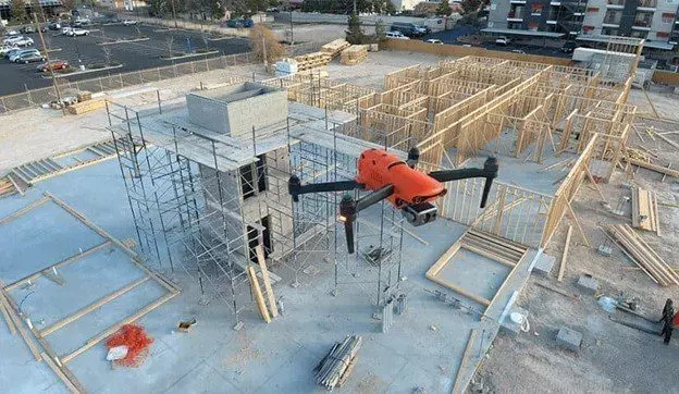
Roof and Facade Inspections
Drones are revolutionizing infrastructure inspection by making it safer, faster, and more cost-effective. Equipped with advanced cameras and sensors, they can identify issues that human inspectors might overlook. This innovation enhances worker safety and efficiency in inspecting bridges, buildings, power lines, and pipelines.
Pipeline and Power Line Monitoring
Using drones for pipeline and power line monitoring offers a safer and more efficient alternative to traditional methods. Drones can cover large areas quickly and provide high-resolution images that help identify potential issues before they become significant problems.
Solar Panel and Wind Turbine Inspections
With recent advancements in drone technology, we can now perform standard solar panel inspections in a fraction of the time. Drones with high-resolution cameras and thermal imaging sensors can detect issues such as hot spots or damaged cells, ensuring optimal performance and longevity of solar panels and wind turbines.
Innovative Mapping and Modeling Solutions

Orthomosaic Mapping
Orthomosaic mapping is a technique that stitches together multiple aerial images to create a detailed, accurate map. This method is beneficial for large-scale surveys and construction progress monitoring. The resulting maps are highly detailed and can be used for various applications, including urban planning and environmental monitoring.
3D Modeling
3D modeling involves creating three-dimensional representations of physical objects or landscapes using aerial imagery. This technology is invaluable for industries such as real estate, where virtual tours and interactive 3D models can provide potential buyers with a comprehensive view of a property. Additionally, 3D models are used in construction to visualize project progress and in agriculture to monitor crop health.
Field Mapping for Agriculture
Field mapping for agriculture uses aerial imagery to gather data on crop conditions, soil health, and irrigation needs. This information helps farmers make informed decisions, ultimately increasing yields and reducing costs. Field mapping for agriculture is a game-changer, providing insights that traditional methods cannot achieve.
Innovative mapping and modeling solutions are transforming industries by providing detailed, accurate data that drives better decision-making and efficiency.
Safety and Compliance in Drone Operations

FAA Certification and Insurance
To ensure safe and legal drone operations, all commercial drone pilots must hold a Part 107 license issued by the FAA. This certification is mandatory for any commercial drone activity in the United States. Additionally, companies like Sky View Las Vegas carry aviation liability insurance ranging from $1 to $10 million, providing peace of mind for clients.
Safety Protocols
Strict operational guidelines are followed to maintain safety and privacy during drone operations. These protocols include pre-flight checks, real-time monitoring, and adherence to federal airspace restrictions. The on-site Pilot in Command has the final authority on all flight matters, ensuring safety is never compromised.
Legal Considerations
Operating drones commercially involves understanding and complying with various legal requirements. This includes registering any UAV weighing 250 grams or more with the FAA and obtaining necessary airspace waivers. Companies must also stay updated on local regulations to avoid legal issues.
Ensuring safety and compliance in drone operations is not just about following rules; it’s about building trust with clients and the community.
Client Access and Data Management
Secure Online Accounts
Clients can log in to their secure accounts to access all the data captured during their drone missions. This includes photos, videos, interactive 3D models, and 2D maps. The platform ensures that all data is stored safely and can be accessed anytime.
Data Analysis Tools
Our service provides advanced tools for analyzing the captured data. Clients can take accurate distance, area, volume, and elevation measurements using interactive 2D maps. These tools help generate detailed maps, 3D models, and progress reports, providing project managers and stakeholders with real-time insights into the construction progress.
Interactive 3D Models and 2D Maps
The platform offers interactive 3D models and 2D maps that clients can explore. These models and maps are visually impressive and functional, allowing for precise measurements and detailed inspections. This feature is handy for construction and real estate industries, where visual and spatial data are crucial.
Our data management system ensures that clients have easy and secure access to all their aerial data, making it simple to analyze and utilize the information effectively.
Custom Drone Services and Packages

Tailored Solutions for Businesses
Our drone services are designed to meet each client’s unique needs. Whether you need aerial photography, videography, or specialized inspections, we offer customized solutions to fit your requirements. Our team of skilled UAV pilots ensures that every project is executed precisely and professionally.
Flexible Service Packages
We understand that every project is different. That’s why we provide flexible service packages that can be adjusted to suit your specific needs. From one-time projects to ongoing contracts, our packages are designed to offer the best value for your investment. Here are some of the options available:
- Basic Package: Ideal for small projects requiring a few aerial photos or a short video.
- Standard Package: Perfect for medium-sized projects with more extensive photo and video needs.
- Premium Package: Best for large projects that require comprehensive aerial services, including editing and post-production.
Consultation and Booking Process
Getting started with our drone services is easy. Follow these steps:
- Contact Us: Contact us via phone or email to discuss your project needs.
- Consultation: We’ll schedule a consultation to understand your requirements and provide expert advice.
- Quote: We’ll provide a detailed quote outlining the services and costs based on the consultation.
- Booking: Once you approve the quote, we’ll schedule the drone services at a time that works best for you.
Our goal is to provide top-notch aerial services that exceed your expectations. Contact us today to learn more about our custom drone services and packages.
Discover our custom drone services and packages designed to meet your unique needs. Whether for real estate, events, or commercial projects, our expert team is ready to capture stunning aerial footage. Don’t miss out on elevating your visuals—visit our website today to learn more!
Conclusion
In conclusion, Las Vegas Aerial Services offers a comprehensive range of drone solutions tailored to various industries’ diverse needs. Their FAA-approved pilots and state-of-the-art equipment ensure high-quality and safe operations in industries ranging from real estate to agriculture. They provide detailed data and insightful analysis to help clients make informed decisions, ultimately driving efficiency and profitability. Whether you need stunning aerial photography or precise condition monitoring, Las Vegas Aerial Services is a reliable and professional choice in the aerial services market.
Frequently Asked Questions
What types of aerial services do you offer in Las Vegas?
We provide various aerial services, including photography, videography, roof and facade inspections, pipeline monitoring, solar panel inspections, and more.
Are your drone pilots certified and insured?
Yes, all our drone pilots are FAA-certified, and we carry a $1,000,000 drone liability insurance policy for all operations.
How can I access the data captured by your drones?
Clients can access all captured data, including photos, videos, and interactive 3D models, through a secure online account.
What industries do you serve with your aerial services?
We serve multiple industries, such as construction, real estate, energy, agriculture, etc.
Can you provide custom drone services tailored to my needs?
Absolutely! We offer custom drone services and flexible packages to meet the specific needs of your business.
How do I book a drone service with you?
You can book a service via our website or by calling 702.670.1067. We will discuss your needs and schedule a drone mission at your earliest convenience.