Las Vegas Aerial Photography

Las Vegas Aerial Photography. Las Vegas is renowned for its vibrant lights, opulent casinos, and bustling streets. But have you ever wondered what it looks like from above? Aerial photography gives us a unique view of this vibrant city. From the early days to the latest drone technology, capturing Las Vegas from the sky has always been an intriguing experience.
Key Takeaways
- Aerial photography offers a unique perspective of Las Vegas, showcasing its iconic landmarks and vibrant cityscape.
- The technology used in aerial photography has evolved significantly, from early aircraft to modern drones.
- Aerial images have played a crucial role in urban development, enabling planners and developers to visualize and design cities effectively.
- Different techniques and equipment, such as helicopters and high-resolution cameras, enhance the quality of aerial photos.
- Aerial photography is widely used across industries, including real estate, tourism, and event documentation.
The Evolution of Las Vegas Aerial Photography
Early Beginnings and Historical Significance
The history of aerial photography in Las Vegas dates back to the early 20th century. The first aerial photos were taken using balloons and primary cameras. These early images capture the settlement of Las Vegas, Nevada, which was founded in 1905 after the opening of a railroad linking Los Angeles and Salt Lake City. These photos are now valuable historical records, showing the city’s growth from a small town to a bustling metropolis.
Technological Advancements Over the Decades
Over the years, technology has dramatically improved aerial photography. In the 1950s and 1960s, airplanes equipped with better cameras started to be used. By the 1990s, helicopters and drones had become widely used, offering greater flexibility and higher-quality imagery. Today, high-resolution cameras and advanced drones allow photographers to capture stunning aerial views of Las Vegas with incredible detail.
Impact on Urban Development
Aerial photography has played a crucial role in Las Vegas’s urban development. City planners and developers use these images to plan new projects and monitor growth. The detailed aerial views help inform decisions on land use, infrastructure, and environmental impact, which have been essential to transforming Las Vegas into the vibrant city it is today.
Iconic Landmarks Captured from Above
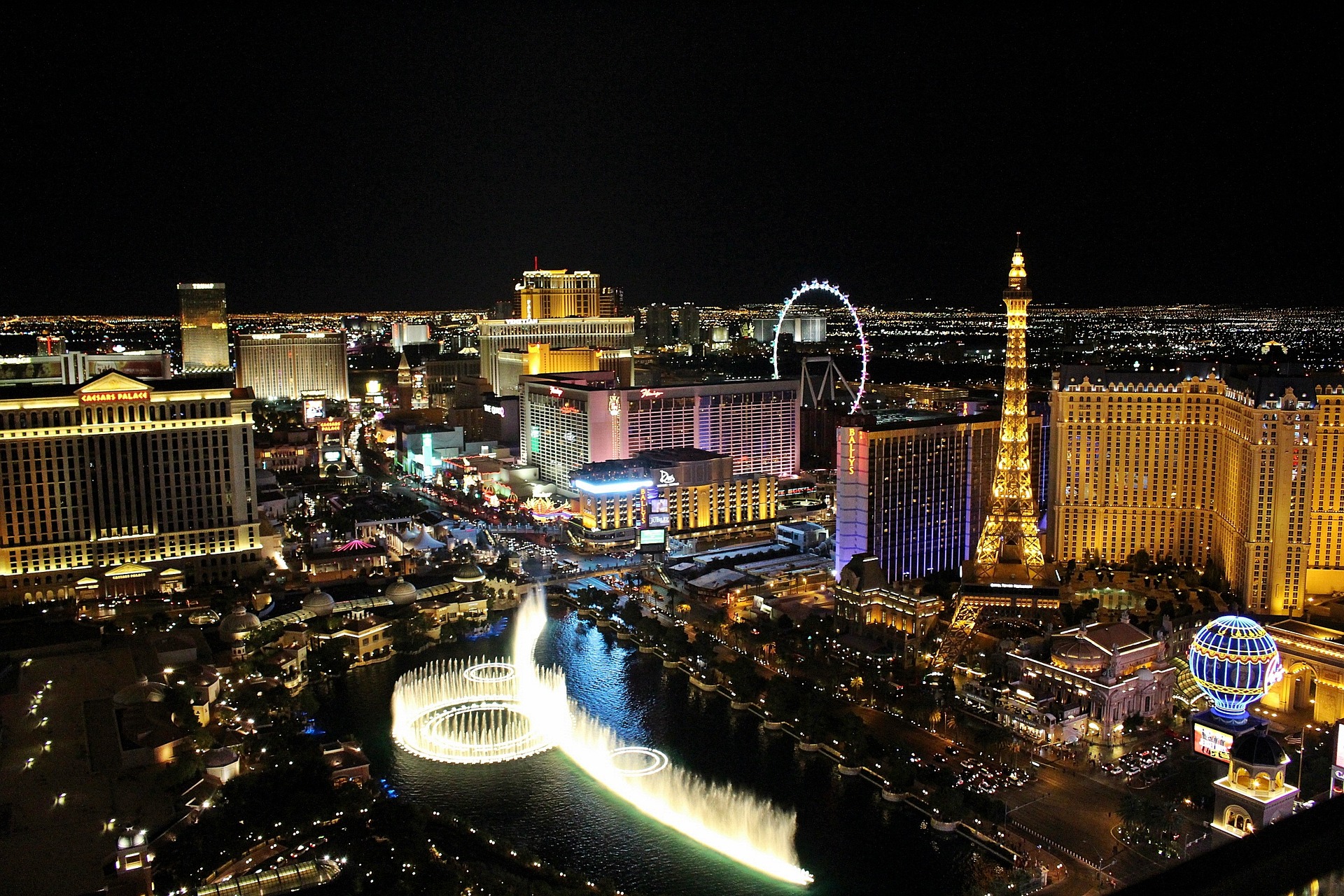
The Las Vegas Strip
The Las Vegas Strip is one of the most recognizable locations in the world. Capturing it from above offers a unique city perspective, showcasing the vibrant lights and bustling activity. Aerial shots highlight the grandeur and scale of the Strip, making it a favorite subject for photographers.
Famous Casinos and Hotels
From the Bellagio to the MGM Grand, Las Vegas is home to some of the most famous casinos and hotels. Aerial photography can capture these iconic landmarks in a new light, emphasizing their architectural beauty and the excitement they bring to the city.
Natural Landscapes and Surrounding Areas
Beyond the city lights, Las Vegas is surrounded by stunning natural landscapes. Aerial views of Red Rock Canyon, the Hoover Dam, and Lake Mead contrast the urban environment. These images showcase the region’s diverse beauty, from rugged mountains to serene bodies of water.
Techniques and Equipment Used in Aerial Photography
Helicopters vs. Drones
When it comes to Aerial Photography, both helicopters and drones offer distinct advantages. Helicopters can fly higher and cover larger areas, making them ideal for capturing expansive landscapes and urban settings. On the other hand, drones are more versatile and can navigate tighter spaces, offering a wider range of creative angles and perspectives. However, achieving stable shots from a moving platform, whether a drone or a helicopter, requires a keen understanding of photographic equipment and techniques.
High-Resolution Cameras and Lenses
The quality of aerial photos heavily depends on the cameras and lenses used. High-resolution cameras are essential for capturing detailed images from above. These cameras often feature specialized lenses that enable precise zooming into specific areas without compromising clarity. Combining high-resolution cameras and advanced lenses ensures that every shot is crisp and clear.
Post-Processing and Image Enhancement
After capturing the images, post-processing is crucial to bring out the best in each shot. This involves adjusting the brightness, contrast, and color settings to make the photos appear more vibrant. Image enhancement techniques can also remove any distortions or imperfections, ensuring the final product is of the highest quality.
In the world of aerial photography, the right techniques and equipment can make all the difference between a good shot and a breathtaking one.
Applications of Aerial Photography in Las Vegas
Real Estate and Development
Aerial photography has become a game-changer in the real estate industry. It gives potential buyers a bird ‘s-eye view of properties, showcasing the buildings and surrounding areas. This is especially useful in a city like Las Vegas, where the landscape can vary significantly from one neighborhood to another. Developers use aerial shots to plan new projects and track the progress of ongoing construction.
Tourism and Marketing
Las Vegas thrives on tourism, and aerial photography plays a crucial role in marketing its attractions. Brochures, websites, and social media use high-quality aerial images of the Las Vegas Strip, famous casinos, and natural landscapes to attract visitors. These stunning visuals help create a compelling narrative that draws people to the city.
Event Documentation and Media
From concerts to sports events, Las Vegas hosts many large-scale events. Aerial photography provides a unique perspective that ground-level shots can’t capture. Media outlets frequently utilize aerial footage to cover these events, providing viewers with a comprehensive view of the action. This type of photography is also used for event planning, helping organizers better understand the layout and logistics of large venues.
Challenges and Considerations in Aerial Photography
Navigating No-Drone Zones
Operating drones in Las Vegas presents unique challenges. One of the most significant is navigating no-drone zones. The Federal Aviation Administration (FAA) has designated specific areas where drones are prohibited from flying. These restrictions are in place to ensure safety and privacy. For instance, areas around airports and certain government buildings are off-limits. Drone pilots must be well-versed in these regulations to avoid fines and legal issues.
Weather and Lighting Conditions
The weather can be unpredictable and plays a crucial role in aerial photography. High winds, rain, and extreme temperatures can affect photo quality and flight safety. Pilots must check weather forecasts and be prepared to reschedule flights if unfavorable conditions are present. Additionally, the time of day and lighting conditions can significantly impact the quality of aerial photos. Early morning or late afternoon often provides the best natural light.
Safety and Legal Regulations
Safety is paramount in aerial photography. Pilots must adhere to strict safety protocols to protect people and property on the ground. This includes maintaining a safe distance from crowds and buildings. Legal regulations also play a significant role. Pilots must hold the necessary certifications and obtain the required permissions to operate drones commercially. This often means obtaining a Part 107 license from the FAA in Las Vegas.
The unique challenges of being a drone pilot in Las Vegas require a deep understanding of regulations, weather patterns, and safety protocols. Staying informed and adaptable is key to capturing stunning aerial footage while navigating these obstacles.
Case Studies: Memorable Aerial Shots of Las Vegas
Historic Aerial Photos
Las Vegas has a rich history captured through aerial photography. One notable image is an aerial shot of the Las Vegas Strip taken on July 25, 1967, showcasing iconic landmarks such as Caesars Palace and the Flamingo. Another significant photo from 1958 shows the triangular runways of McCarran Field, now known as Harry Reid International Airport. These images provide a unique perspective on the city’s rapid growth and urbanization.
Modern Aerial Photography Projects
Modern aerial photography projects have continued documenting the city’s evolution in recent years. Companies like Sky View LV have been serving Las Vegas since 2017, offering high-resolution digital aerial photography for real estate and marketing purposes. Their work highlights the city’s ongoing development and expansion, capturing everything from new hotel casinos to residential areas.
Client Testimonials and Success Stories
Clients have praised the quality and impact of aerial photography in Las Vegas. For instance, M. Johnson from RES Group commended Sky View Las Vegas for their exceptional service and attention to detail. He noted that their aerial images have been instrumental in marketing and client research, providing a comprehensive view of properties and developments.
Aerial photography offers a unique perspective that ground-level photos simply cannot match. It allows for a broader view of the landscape, making it an invaluable tool for various industries.
Future Trends in Las Vegas Aerial Photography
Emerging Technologies
The future of aerial photography in Las Vegas is set to be transformed by emerging technologies. Innovations such as AI-powered drones and advanced imaging software are expected to enhance the quality and efficiency of aerial image capture. These technologies will enable more precise, detailed shots, making it easier to capture the city’s unique perspectives.
Sustainability and Environmental Impact
As the world becomes increasingly aware of environmental issues, the aerial photography industry in Las Vegas is also shifting towards more sustainable practices. Electric drones and eco-friendly materials are being developed to reduce the carbon footprint of aerial photography. This shift helps the environment and appeals to clients who prioritize sustainability.
Predictions for the Next Decade
In the next ten years, we can expect several exciting developments in the field of aerial photography in Las Vegas:
- Increased Use of AI: AI will significantly automate flight path planning and image processing, improving efficiency.
- Enhanced Image Quality: As camera technology advances, the resolution and clarity of aerial images will continue to improve.
- Greater Accessibility: As technology becomes more affordable, aerial photography services will be available to a broader range of clients.
The future of aerial photography in Las Vegas is bright, with technological advancements and a focus on sustainability leading the way. These trends will not only improve the quality of aerial images but also make the process more efficient and environmentally friendly.
Conclusion
Aerial photography in Las Vegas offers a unique perspective on the city. From the bright lights of the Strip to the historic landmarks, these images capture the essence of this vibrant city. Whether for real estate, marketing, or to appreciate the beauty of Las Vegas, aerial photos offer a perspective that can’t be achieved from the ground. As technology advances, the quality and accessibility of aerial photography will continue to improve, making it an exciting field to watch.
Frequently Asked Questions
What is aerial photography?
Aerial photography involves capturing images from an aircraft or other flying objects, such as planes, helicopters, drones, or balloons.
Why is aerial photography important for real estate?
Aerial photography gives a bird’s-eye view of properties, showing their layout and the surrounding area. This helps buyers and developers see a property’s full potential.
How do drones compare to helicopters for aerial photography?
Drones are more affordable and can get closer to the ground, but helicopters can fly higher and cover larger areas. Depending on the project, each has its advantages.
What are the legal considerations for aerial photography in Las Vegas?
In Las Vegas, it is essential to be aware of drone zones and other FAA regulations. Following all safety and legal guidelines is necessary to avoid fines or penalties.
How has aerial photography technology improved over the years?
Technology has advanced significantly with the advent of high-resolution cameras, advanced drones, and sophisticated software for editing and image enhancement. These advancements have made aerial photography more accessible and of high quality.
Can weather conditions affect aerial photography?
Yes, weather conditions such as wind, rain, and fog can affect the quality of aerial photos. It’s best to schedule shoots on clear days for the best results.
Popular Posts

May 11, 2026
May 07, 2026

April 03, 2026

February 11, 2026
Comments are closed.