Aerial Photography in Las Vegas from above

Aerial photography in Las Vegas provides a unique perspective on one of the world’s most vibrant cities. From the glitz and glamour of the Las Vegas Strip to the natural beauty of the surrounding landscapes, aerial images capture the essence of this dynamic city. This article explores the evolution, current practices, and future trends in aerial photography in Las Vegas, providing valuable insights for enthusiasts and professionals alike.
Key Takeaways
- Aerial photography has played a significant role in documenting the city’s historical and urban development.
- Technological advancements have greatly enhanced the quality and accessibility of aerial photography and drone services.
- Iconic landmarks such as the Las Vegas Strip and famous hotels are popular subjects for aerial photography.
- Strict FAA regulations govern drone photography services in Las Vegas to ensure safety and compliance.
- The future of aerial photography in Las Vegas looks promising, with emerging technologies and new applications on the horizon.
The Evolution of Aerial Photography in Las Vegas
Early Beginnings and Historical Significance
Aerial photography in Las Vegas has a rich history, dating back to the early 20th century. Initially, it was used for mapping and surveying, providing a bird’s-eye view of the rapidly growing city. These early images captured the transformation of Las Vegas from a small desert town to a bustling metropolis.
Technological Advancements Over the Decades
Over the years, technological advancements have revolutionized aerial photography. Each innovation has enabled the capture of more detailed and accurate images, ranging from balloons and kites to modern drones and satellites. Today, capturing Las Vegas in a whole new light is possible thanks to companies like Sky View LV, which are leading the way in innovative technology.
Impact on Urban Development
Aerial photography has played a crucial role in Las Vegas’s urban development. It has been utilized for planning and development, enabling city planners and developers to make informed decisions. The ability to view the city from above has provided valuable insights into traffic patterns, land use, and the city’s overall layout.
The evolution of aerial photography has not only documented the growth of Las Vegas but also contributed to its development by providing essential data and insights.
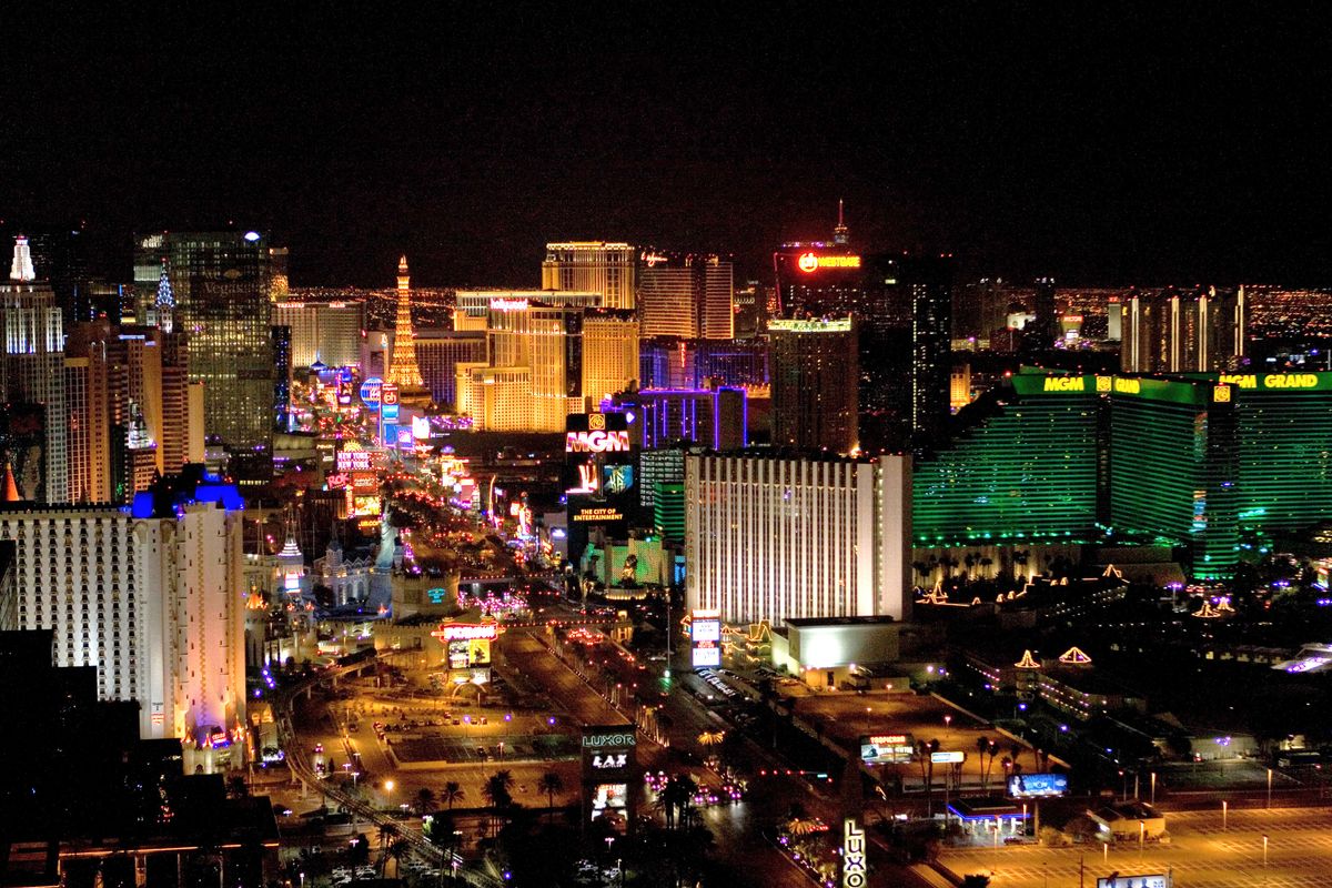
Iconic Landmarks Captured from Above
Las Vegas truly comes alive when viewed from above. Aerial photography in Las Vegas offers a unique perspective on its iconic landmarks and architectural marvels. From the dazzling lights of the Strip to the natural beauty of the surrounding landscapes, capturing these sights from above provides an unparalleled experience.
Drone Photography Services in Las Vegas

Numerous leading drone service providers in Las Vegas offer top-notch aerial photography and videography. These companies employ handpicked, experienced drone pilots who are FAA Part 107 licensed and insured. They provide a range of services, from capturing stunning aerial shots to producing high-quality videos. Some of the most notable providers include We Fly, which utilizes advanced equipment such as the DJI Inspire 2 and MFD 5000 heavy-lift drones. Operating drones in Las Vegas requires strict adherence to FAA regulations and safety measures. All drone pilots must be Part 107 certified to ensure they understand the rules and operate safely.
Additionally, these providers carry substantial insurance policies, often up to $5 million, to cover potential liabilities. Safety is a top priority; companies take extensive measures to ensure every flight is conducted without incident. Drone photography in Las Vegas is utilized for a variety of purposes. Some of the most popular uses include:
- Real estate marketing
- Event Coverage
- Film and TV production
- Construction site monitoring
- Tourism promotion
These applications highlight the versatility and value of drone photography in capturing unique perspectives and delivering high-quality visual content.
Aerial Photography for Real Estate and Development
Marketing and Promotional Uses
Real Estate Aerial Photography has become a game-changer in the competitive real estate market. High-quality aerial images and videos can showcase properties in ways traditional ground-level photography cannot. This type of photography effectively showcases the property’s location, surrounding amenities, and overall appeal, making it a crucial tool for marketing and promotional efforts.
Site Analysis and Planning
Aerial photography is invaluable for site analysis and planning. It provides a comprehensive view of the land, helping developers and planners make informed decisions. From assessing topography to understanding the impact of nearby structures, aerial images offer a level of detail crucial for effective planning.
Client and Investor Presentations
Aerial photography can significantly impact client and investor presentations. High-resolution images and videos can be used to create compelling presentations that highlight the key features of a property or development project. This impresses clients and investors, helping to secure funding and approvals.
Utilizing aerial photography for real estate and development projects can significantly enhance the visibility and appeal of properties, making it a must-have tool in today’s market.
Challenges and Considerations in Aerial Photography
Weather and Environmental Factors
Weather conditions play a crucial role in aerial photography. High winds, rain, and extreme temperatures can significantly affect image quality. Bold. Environmental factors, such as dust and pollution, can also obscure visibility, making it challenging to capture precise shots. Monitoring weather forecasts and planning shoots accordingly are essential to avoid these issues.
Legal and Regulatory Hurdles
Navigating the legal landscape is another significant challenge. The Federal Aviation Administration (FAA) has established “no-drone zones” where drones are prohibited from operating. This can limit the areas where aerial photography can be conducted. Moreover, obtaining the necessary permits and ensuring compliance with local regulations can be time-consuming and complex.
Technical Challenges and Solutions
Aerial photography presents several technical challenges, including equipment malfunctions and limited battery life. Traditional aerial imagery, although valuable, has limitations, including higher costs and insufficient coverage over extended periods compared with satellite imagery. To mitigate these issues, it’s crucial to have backup equipment and contingency plans. Regular maintenance and updates to the equipment can also help in minimizing technical difficulties.
The Future of Aerial Photography in Las Vegas
Emerging Technologies and Trends
The future of aerial photography in Las Vegas is auspicious, thanks to rapid advancements in drone technology. These innovations are enhancing the quality of aerial images and expanding the range of applications. From high-resolution cameras to AI-driven flight systems, the possibilities are endless.
Sustainability and Environmental Impact
As we look ahead, sustainability will play a crucial role in the evolution of aerial photography. Newer drones are designed to be more energy-efficient, reducing their carbon footprint. This shift is essential to minimize environmental impact while capturing stunning aerial views of Las Vegas.
Potential New Applications
The future holds exciting potential for new applications of aerial photography. Beyond traditional uses, we can expect drones to be used in disaster management, wildlife monitoring, and entertainment. These new applications will undoubtedly add a new dimension to the city’s vibrant landscape.
The future of aerial photography in Las Vegas is not just about capturing images; it’s about transforming how we see and interact with the world around us.
Custom Aerial Photography Projects
When it comes to Aerial Photography, one size does not fit all. I offer flexible solutions to meet any project’s needs and deliver professional footage, regardless of location. Whether for commercial real estate, construction, or special events, my services are designed to meet your specific requirements. Over the years, I’ve enjoyed working on a variety of custom aerial photography projects. From capturing the intricate details of commercial real estate to providing stunning visuals for marketing campaigns, each project has its unique story. Here are a few highlights:
- Commercial Real Estate: Showcased everything from interior details to broad aerial perspectives.
- Construction: Documented the progress of large-scale construction projects from start to finish.
- Special Events: Captured memorable moments from weddings, festivals, and corporate events.
Booking a custom aerial photography shoot is straightforward. Follow these steps to get started:
- Contact Us: Reach out to discuss your project and specific needs.
- Consultation: We offer a complimentary consultation to help us understand your vision and requirements.
- Custom Quote: Receive a tailored quote based on your project’s scope and complexity.
- Schedule the Shoot: Once the quote is approved, we’ll schedule the shoot at a time that’s convenient for you.
- Delivery: After the shoot, you’ll receive professionally edited footage ready for use.
For any unique aerial photography needs, don’t hesitate to get in touch. I’m here to help bring your vision to life.
Discover the magic of custom aerial photography projects with Sky View LV. Our expert drone pilots are ready to capture stunning, high-resolution images tailored to your needs. Don’t miss the opportunity to bring your vision to life. Visit our website today for a free consultation and see how we can elevate your project!
Conclusion
Aerial photography in Las Vegas offers a unique and captivating perspective of this vibrant city. From historical images that capture the evolution of the cityscape to modern drone photography that showcases the dazzling lights of the Strip, the field has grown immensely. Companies like Aerial Archives and Skylab Aerial Photo provide invaluable services, serving clients ranging from real estate developers to filmmakers. Whether for historical documentation or cutting-edge marketing, aerial photography is essential in capturing the essence of Las Vegas. As technology advances, the possibilities for aerial imagery are limitless, promising even more breathtaking views of this iconic city.
Frequently Asked Questions
What are the best times of year for aerial photography in Las Vegas?
The best times for aerial photography in Las Vegas are spring and fall, when the weather is mild, and visibility is typically straightforward.
Are there any restrictions on drone photography in Las Vegas?
Yes, drone photography in Las Vegas is subject to FAA regulations, including restrictions on flying near airports and crowds. Always check local rules before conducting a shoot.
What is the cost of a custom aerial photography shoot?
The cost of a custom aerial photography shoot varies based on the project scope and duration. It’s best to contact service providers directly for a detailed quote.
What types of aerial photography services are available in Las Vegas?
Services range from high-resolution digital photography and videography to 3D mapping and thermal imaging. Providers cater to a range of needs, including real estate, marketing, and urban planning.
How can I book an aerial photography session in Las Vegas?
You can book a session by contacting local aerial photography service providers through their websites or by phone. Many offer online forms to specify your project details.
What safety measures are in place for drone photography?
Safety measures include FAA certification for pilots, adherence to no-fly zones, and comprehensive insurance coverage. Providers also conduct pre-flight checks to ensure their equipment is safe.
Popular Posts

April 03, 2026

February 11, 2026
February 11, 2026

January 23, 2026

January 22, 2026

November 14, 2025
Comments are closed.