The Use of Drones in Construction
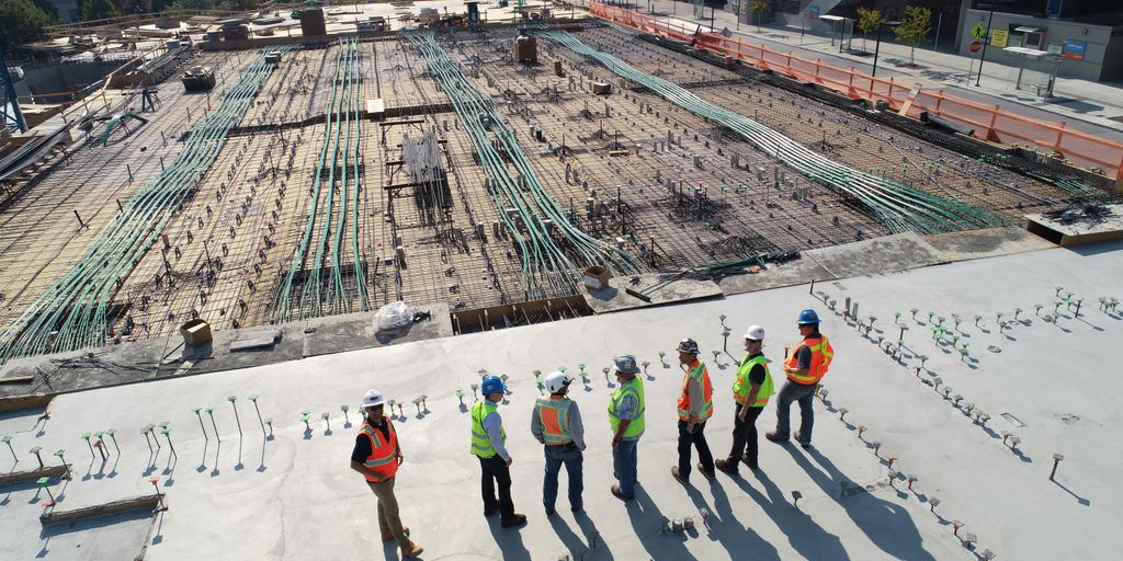
The Role of Drones in Construction: Applications, Benefits & Future Trends
Drones, officially known as Unmanned Aerial Vehicles (UAVs), are driving a technological transformation across the construction industry. From high-precision land mapping to proactive job-site safety assessments, drone technology enables construction teams to operate more efficiently, reduce overhead costs, and streamline decision-making.
Below, we examine how drones are transforming job sites today, the key benefits they deliver, and what the future holds for aerial site management.
Key Takeaways
-
Versatile Applications: Drones assist in land surveying, progress tracking, equipment monitoring, and safety checks.
-
Increased Efficiency & Savings: Automated aerial mapping accelerates project timelines and minimizes costly manual errors.
-
Enhanced Site Safety: Remote inspections reduce worker risk in elevated or hazardous locations.
-
Detailed Structural Inspections: High-resolution cameras and thermal sensors perform non-destructive, detailed building evaluations.
-
Future-Ready Tech: The next era of construction drones will rely heavily on AI integration, advanced automation, and evolving safety regulations.
Key Applications of Drones in Construction
Drones add measurable value at every stage of a construction project’s lifecycle. By delivering rapid aerial insights and real-time data, UAVs have quickly become indispensable tools on modern job sites.
1. Land Surveying & Topographic Mapping
Traditional land surveying can take days or even weeks. Equipped with specialized cameras and GPS units, drones can map dozens of acres in hours, generating high-density point clouds and accurate 3D topographic models.
2. Progress Monitoring & Stakeholder Reporting
Regular drone flights provide project managers, clients, and investors with a visual timeline of the site. Automated flight paths ensure consistent photo angles for seamless side-by-side progress comparisons.
3. Equipment & Inventory Tracking
Large construction sites often struggle with asset management. Aerial views allow logistics managers to locate heavy machinery, track material stockpiles (such as gravel or dirt volumes), and optimize material distribution across the site.
Impact of Drones on Project Efficiency and ROI
Integrating drones into construction workflows yields a direct, positive impact on a project’s bottom line.
Accelerated Project Timelines
By automating land measurement and data collection, teams receive actionable insights faster. Swift data consolidation enables project managers to make informed decisions quickly and keep schedules on track.
Substantial Cost Savings
-
Reduced Manual Overhead: Minimizes the need for large surveying crews in dangerous terrain.
-
Early Error Detection: Identifies discrepancies between actual construction and design blueprints before costly rework is required.
Higher Data Accuracy
Drones capture millions of data points per flight, providing precise spatial data that seamlessly integrates into Building Information Modeling (BIM) software for superior execution.
Enhancing Job-Site Safety with Remote Monitoring
Fall hazards and heavy machinery operations make construction sites inherently high-risk environments. Drones offer a proactive approach to site safety management.
-
Real-Time Hazard Identification: Drones can perform quick aerial sweeps to spot unsafe equipment placement, missing personal protective equipment (PPE), or unauthorized personnel in hazardous zones.
-
Scaffold-Free Inspections: Safety officers can remotely inspect high-elevation structures without using ladders, scaffolding, or cranes, directly mitigating fall risks—a leading cause of industry injuries.
-
Emergency Overview: In the event of an incident or severe weather, drones provide immediate visual situational awareness to guide emergency response teams safely.
Advanced Structural & Infrastructure Inspections
Structural inspections traditionally require heavy machinery, specialized rigging, and elevated risks. Drone technology streamlines this entire workflow.
       [ High-Res & Thermal Sensors ]
                     │
    ┌────────────────┴────────────────┐
    ▼                                 ▼
Structural Defect Detection      Energy Audit Efficiency
(Cracks, Leaks, & Decay)        (Heat Loss & Electrical)
-
High-Resolution Imaging: Capture macro details to detect hairline cracks, concrete spalling, or rust early in the building lifecycle.
-
Thermal & Infrared Imaging: Detect thermal leaks, moisture infiltration, or overheating electrical components that are invisible to the naked eye.
-
Hard-to-Reach Access: Easily navigate tight angles around bridges, towers, and roofs without risking inspector safety.
Challenges and Implementation Limitations
While the benefits are extensive, deploying drones on construction sites involves specific operational hurdles:
Emerging Future Trends in Construction Drones
As software and hardware continue to evolve, the impact of drones on construction will grow exponentially.
-
AI & Machine Learning Integration: Future drone software will automatically analyze imagery to flag building errors, calculate material volumes, and log safety violations without human intervention.
-
Autonomous Fleet Operations: “Drone-in-a-box” solutions will execute scheduled, autonomous site flights and automatically upload data to the cloud for processing.
-
Standardized Regulatory Frameworks: Governments worldwide are refining regulations to enable beyond-visual-line-of-sight (BVLOS) operations, paving the way for broader automated use.
Conclusion
Drones are no longer just a high-tech novelty—they are a core strategic advantage in modern construction. By improving safety, providing precise site data, and drastically reducing project timelines, UAV technology helps companies stay competitive, on schedule, and within budget.
Frequently Asked Questions (FAQ)
What are the main uses of drones in construction?
Drones are primarily used for site surveying, 3D topographic mapping, progress tracking, safety checks, inventory monitoring, and structural inspections.
How do drones help cut construction costs?
They reduce manual labor hours for surveying, prevent costly design errors through early detection, and minimize downtime by providing real-time data.
Can drones replace traditional land surveyors?
No. Drones serve as a powerful tool for licensed surveyors, dramatically speeding up data collection while leaving final analysis and certification to qualified professionals.
What equipment is required for drone construction inspections?
Typically, a commercial-grade drone equipped with high-resolution cameras, RTK/PPK GPS modules for high precision, and optional thermal or LiDAR sensors is required.
Popular Posts

August 24, 2026

August 23, 2026
August 22, 2026
August 20, 2026
August 19, 2026

August 18, 2026
Comments are closed.