In today’s fast-paced real estate market, capturing buyer attention quickly is critical—especially in the commercial sector, where deals involve significant investments and complex decision-making. Traditional photos and static listings are no longer enough to impress modern buyers. This is where commercial real estate drone video and aerial imagery are making a major impact.
Drone footage has become one of the most powerful tools for showcasing commercial properties. By offering dynamic, high-quality visuals from unique perspectives, businesses can present properties in a way that drives faster interest, stronger engagement, and ultimately quicker sales. Companies like Sky View LV are helping real estate professionals leverage this technology to stay ahead in competitive markets like Las Vegas.
Let’s explore how drone footage is transforming commercial real estate and why it helps properties sell faster.
Capturing Attention Instantly
First impressions matter, especially online. Most buyers begin their property search digitally, scrolling through listings and evaluating options within seconds. Drone footage stands out immediately.
When potential buyers see a professionally produced drone video, they are more likely to stop, watch, and explore further. This increased attention significantly improves the chances of generating leads.
Showcasing the Full Property Scope
Commercial properties are often large and complex. Ground-level photography struggles to capture the complete picture. Drone footage solves this problem by providing a comprehensive view.
What Aerial Footage Reveals:
Property size and layout
Parking areas and access points
Surrounding infrastructure
Nearby businesses and amenities
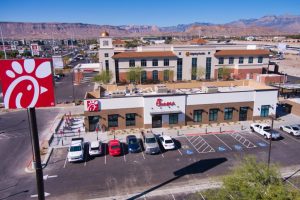
For example, aerial photography Las Vegas projects can highlight proximity to major roads, business hubs, and landmarks—key factors that influence buyer decisions.
By giving buyers a clear understanding of the property, drone footage reduces uncertainty and builds confidence.
Enhancing Property Storytelling
Selling commercial real estate isn’t just about showing a building—it’s about telling a story. Buyers want to understand how a property fits into their business goals.
Drone videos allow agents to:
Create guided visual tours
Highlight unique selling points
Showcase the property in context
This storytelling approach makes listings more memorable and persuasive. Companies like Sky View LV specialize in crafting compelling visuals that resonate with potential investors and business owners.
Attracting Out-of-Town and International Buyers
Las Vegas is a global business hub, attracting investors from across the country and around the world. Many of these buyers cannot visit properties in person initially.
Drone footage bridges this gap by offering a virtual experience.
Benefits for Remote Buyers:
View the property from multiple angles
Understand the surrounding area
Make informed decisions without traveling
This is especially valuable for commercial drone photography projects targeting high-value investors. High-quality aerial visuals can significantly shorten the decision-making process.
Increasing Online Engagement and Visibility
Listings with video content consistently outperform those without. Drone footage takes this a step further by delivering visually striking content that encourages interaction.
Impact on Marketing Performance:
Higher click-through rates
Longer time spent on listings
Increased social media shares
More inquiries from potential buyers
When combined with drone photography Las Vegas services, video content creates a complete visual package that maximizes exposure.
Building Trust and Professional Credibility
High-quality visuals reflect professionalism. When a property is presented with polished drone footage, it signals that the seller is serious and detail-oriented.
Working with an FAA certified drone pilot Las Vegas ensures:
Compliance with regulations
Safe and professional operations
Superior video quality
Trusted providers like Sky View LV deliver consistent results that enhance brand credibility and buyer confidence.
Highlighting Location Advantages
In commercial real estate, location is everything. Drone footage excels at showcasing location benefits in a way that static images cannot.
Key Location Features to Highlight:
Proximity to highways and transport hubs
Nearby commercial centers
Surrounding neighborhoods
Visibility and accessibility
For example, a commercial real estate drone video Nevada project can demonstrate how easily customers or employees can access a property—an important factor for many businesses.
Sales Cycle (Faster Decision-Making)
The more information buyers have upfront, the faster they can make decisions. Drone footage provides a comprehensive view that answers many initial questions.
How It Speeds Up Sales:
Reduces the need for multiple site visits
Eliminates uncertainties about property layout
Provides clear visual context
As a result, buyers move through the decision-making process more quickly, leading to faster transactions.
Cost-Effective Marketing Investment
Compared to traditional aerial filming methods like helicopters, drones offer a more affordable solution with equally impressive results.
Why Businesses Choose Drones:
Lower production costs
Faster turnaround times
High-quality output
Investing in aerial drone photography services delivers a strong return on investment by improving marketing effectiveness and reducing time on the market.
Supporting Large-Scale Commercial Projects
For developers and investors, drone footage is invaluable for showcasing large-scale projects. It provides a clear overview of development progress and future potential.
Use Cases:
Pre-construction marketing
Progress updates for stakeholders
Promotional videos for investors
In growing markets like Las Vegas, where development is constant, drone visuals play a crucial role in project marketing.
Competitive Advantage in a Crowded Market
Commercial real estate is highly competitive. Properties that stand out visually are more likely to attract attention and close deals faster.
Drone footage provides that edge by:
Differentiating listings from competitors
Creating memorable impressions
Enhancing overall marketing quality
Companies like Sky View LV help clients leverage this advantage by producing high-impact aerial visuals tailored to their goals.
The Future of Commercial Real Estate Marketing
Drone technology continues to evolve, offering even more possibilities for real estate marketing.
Emerging Trends:
Integration with virtual reality (VR) tours
Interactive property maps
AI-enhanced video editing
Advanced data visualization
As these innovations become more accessible, drone footage will play an even bigger role in selling commercial properties.
Conclusion
Drone footage has revolutionized the way commercial properties are marketed and sold. By providing dynamic, comprehensive, and visually compelling content, it helps businesses attract more buyers, build trust, and close deals faster.
From showcasing property scale to highlighting location advantages and engaging remote investors, commercial real estate drone video is a powerful tool that delivers real results.
In a competitive market like Las Vegas, partnering with professionals like Sky View LV ensures that your property stands out and reaches the right audience effectively.
If you’re looking to sell commercial properties faster, investing in drone footage isn’t just an option—it’s a strategic advantage.
Las Vegas is a city built on spectacle. From its world-famous Strip to its ever-expanding suburbs and commercial developments, the city thrives on visual impact. In recent years, one trend has stood out across industries—the growing demand for aerial photography in Las Vegas.
Businesses are no longer satisfied with traditional visuals. They want dynamic, high-quality imagery that captures attention instantly. This is where drone technology comes in. Companies like Sky View LV are at the forefront of this shift, helping brands and industries harness the power of aerial visuals to stand out in a competitive market.
But what exactly is driving this demand? Let’s take a deeper look.
A City Built for Visual Storytelling
Las Vegas offers a unique landscape that is perfectly suited for aerial imagery. From the dazzling lights of the Strip to the scenic desert surroundings and modern residential developments, the city provides endless opportunities for stunning visuals.
Drone photography in Las Vegas allows businesses to:
Capture масштаб (scale) and grandeur
Highlight location advantages
Showcase surroundings in a single frame
Whether it’s a luxury hotel, a real estate development, or a large event venue, aerial photography brings out the full story in a way ground-level shots simply cannot.
The Real Estate Boom and Aerial Imaging
One of the biggest drivers behind the rise of aerial photography is the booming real estate market. Both residential and commercial sectors are leveraging real estate drone photography to attract buyers and investors.
Why Real Estate Needs Aerial Photography:
Comprehensive Property Views: Show the entire layout, including nearby amenities
Better Buyer Experience: Help potential buyers visualize the property
Stronger Listings: Listings with aerial visuals perform significantly better
In areas like Summerlin and Henderson, where master-planned communities are expanding rapidly, aerial photography has become an essential marketing tool. Companies such as Sky View LV help agents and developers create compelling listings that stand out.
A New Standard in Marketing and Advertising
Modern marketing is visual-first. Businesses across industries are investing in aerial videography services to create eye-catching promotional content.
How Businesses Use Drone Visuals:
Social media campaigns
Website banners and landing pages
Video advertisements
Event promotions
Aerial visuals instantly elevate brand perception. For example, a resort showcasing its property through sweeping drone shots creates a far more immersive experience than static images.
This is why commercial drone photography is no longer a luxury—it’s becoming a standard marketing asset.
Growth in Construction and Development Projects
Las Vegas continues to grow, with new construction projects shaping the city’s skyline. This growth has fueled demand for drone construction monitoring in Las Vegas.
Benefits for Construction Companies:
Track progress in real-time
Improve project planning
Enhance communication with stakeholders
Maintain visual records of development
Drones provide a safer and more efficient way to monitor large-scale projects. Instead of relying on manual inspections, companies can capture detailed aerial data quickly and accurately.
Tourism and Hospitality Industry Adoption
Tourism is the backbone of Las Vegas, and businesses in this sector rely heavily on visuals to attract visitors. Aerial photography helps hotels, casinos, and attractions showcase their offerings in a compelling way.
Key Uses:
Highlighting property features
Showcasing nearby attractions
Creating promotional videos
With millions of visitors each year, standing out is crucial. Aerial visuals give businesses a competitive edge by creating memorable impressions before visitors even arrive.
Cost-Effective and Accessible Technology
One of the reasons behind the surge in demand is the affordability of drone services. Previously, aerial shots required helicopters or expensive equipment. Today, drones provide a cost-effective alternative.
Advantages:
Lower production costs
Faster turnaround times
High-quality results
Businesses of all sizes can now invest in aerial drone photography services without exceeding their budgets.
Importance of Hiring Certified Professionals
As demand grows, so does the importance of working with qualified professionals. Hiring an FAA certified drone pilot Las Vegas ensures safety, compliance, and high-quality results.
Professional providers like Sky View LV offer:
Expertise in aerial photography and videography
Knowledge of local regulations
Advanced equipment for superior results
This level of professionalism is essential, especially for commercial projects and high-value properties.
Expanding Demand in Surrounding Areas
The demand for aerial photography is not limited to central Las Vegas. Nearby areas like Henderson and Summerlin are also seeing rapid growth.
Popular Service Areas:
Residential communities
Commercial developments
Event venues
Drone services Henderson NV and aerial photography Summerlin projects are becoming increasingly common as businesses in these areas adopt modern marketing strategies.
Enhancing Customer Engagement
Visual content plays a critical role in customer engagement. Aerial photography provides a more immersive experience, helping businesses connect with their audience.
Impact on Engagement:
Higher click-through rates
Increased social media interaction
Better conversion rates
When customers can see a property, venue, or project from a unique perspective, they are more likely to engage and take action.
The Future of Aerial Photography in Las Vegas
The demand for aerial photography is expected to grow even further as technology advances.
Emerging Trends:
Integration with 3D virtual tours
Use of AI for image enhancement
Advanced mapping and data analytics
Increased adoption across industries
As these innovations continue to evolve, businesses that invest in aerial photography today will be better positioned for the future.
Why Businesses Choose Sky View LV
With the increasing demand for drone photography Las Vegas, choosing the right service provider is crucial. Sky View LV has established itself as a trusted name in the industry by delivering high-quality aerial visuals tailored to business needs.
From real estate drone services to commercial projects and construction monitoring, Sky View LV helps businesses capture stunning visuals that drive results.
Conclusion
The growing demand for aerial photography in Las Vegas reflects a broader shift toward visual-driven marketing and communication. Businesses across industries are recognizing the value of aerial imagery in enhancing their brand, engaging customers, and staying competitive.
Whether it’s real estate, construction, tourism, or corporate marketing, drone photography offers unmatched advantages. With professional providers like Sky View LV, businesses can unlock the full potential of aerial visuals and take their marketing to new heights.
The real estate industry has always relied on strong visuals to attract buyers, but in today’s digital-first world, traditional photography is no longer enough. Buyers expect immersive, high-quality content that helps them truly understand a property before ever stepping foot on it. This shift has led to a powerful transformation—drone photography is revolutionizing real estate marketing.
From residential listings to large-scale commercial projects, aerial visuals are changing how properties are presented, marketed, and sold. Companies like Sky View LV are helping real estate professionals leverage this technology to create stunning, high-impact content that drives results.
Let’s explore how drone photography is reshaping the real estate landscape and why it has become an essential marketing tool.
The Shift Toward Visual-First Property Marketing
Modern buyers begin their search online, often browsing dozens of listings before narrowing down their options. In this environment, visuals play a critical role in capturing attention.
Real estate drone photography stands out because it offers:
Unique aerial perspectives
Cinematic video content
A more complete view of properties
Unlike traditional photos, drone visuals provide context—showing not just the property, but its surroundings, layout, and overall appeal. This makes listings more engaging and informative.
Showcasing Properties from a New Perspective
One of the biggest advantages of drone photography is the ability to capture properties from angles that were previously impossible or expensive to achieve.
What Aerial Photography Highlights:
Property size and boundaries
Landscaping and outdoor features
Neighborhood and nearby amenities
Access roads and parking areas
For example, aerial photography Las Vegas can showcase a luxury home along with its proximity to golf courses, entertainment hubs, or scenic desert views. This added context helps buyers make more informed decisions.
Increasing Buyer Engagement and Interest
Listings with drone visuals consistently perform better than those without. High-quality aerial images and videos capture attention quickly and keep potential buyers engaged.
Key Benefits:
Higher click-through rates on listings
Longer time spent viewing properties
Increased inquiries and showings
In competitive markets like Las Vegas, where buyers have numerous options, drone photography Las Vegas services help listings stand out and generate more interest.
Sales Process (Faster Property Sales)
One of the most significant impacts of drone photography is its ability to speed up the sales process. When buyers have access to detailed, high-quality visuals, they can make decisions more quickly.
How It Helps:
Reduces uncertainty about the property
Minimizes the need for multiple site visits
Provides a clear understanding of the layout
As a result, properties marketed with aerial drone real estate photography often spend less time on the market.
Enhancing Luxury and High-End Listings
Luxury properties benefit immensely from drone photography. High-end buyers expect premium presentation, and aerial visuals deliver exactly that.
Why It Works for Luxury Real Estate:
Showcases expansive estates and unique features
Highlights scenic views and surroundings
Creates a cinematic, upscale feel
Companies like Sky View LV specialize in capturing these high-end visuals, helping agents attract affluent buyers and justify premium pricing.
Transforming Commercial Real Estate Marketing
Drone photography isn’t limited to residential properties—it’s also transforming commercial real estate.
Applications in Commercial Real Estate:
Office buildings and retail spaces
Industrial properties and warehouses
Large development projects
Commercial drone photography provides a comprehensive view of these properties, helping investors and business owners evaluate opportunities more effectively.
Integrating Video for Immersive Experiences
While aerial photos are powerful, drone videos take things to the next level. Aerial videography services allow agents to create immersive property tours that guide viewers through the space.
Benefits of Drone Video:
Dynamic storytelling
Smooth transitions between areas
Emotional connection with buyers
Video content is particularly effective on social media and real estate platforms, where it can significantly increase engagement.
Building Trust and Professional Credibility
High-quality visuals reflect professionalism and attention to detail. When a listing includes drone photography, it signals that the agent or seller is serious about marketing the property effectively.
Working with an FAA certified drone pilot Las Vegas ensures:
Compliance with regulations
Safe and reliable operations
Consistent, high-quality results
Trusted providers like Sky View LV help real estate professionals maintain a strong brand image through superior visual content.
Cost-Effective Marketing Solution
In the past, aerial photography required helicopters or expensive equipment. Today, drones offer a more affordable and accessible alternative.
Advantages:
Lower production costs
Quick setup and turnaround
High-quality output
This makes aerial drone photography services a practical investment for agents, developers, and property owners.
Highlighting Location and Lifestyle
Real estate is not just about the property—it’s about the lifestyle it offers. Drone photography excels at showcasing location benefits.
What It Captures:
Nearby parks, schools, and amenities
Scenic views and landscapes
Community features
For instance, aerial shots can highlight a property’s proximity to the Las Vegas Strip or other key attractions, adding significant value to the listing.
Supporting New Developments and Pre-Sales
Developers are increasingly using drone photography to market projects before they are completed.
Use Cases:
Pre-construction marketing
Progress updates
Investor presentations
By providing a clear visual representation of the project, drones help generate interest and secure buyers early.
Competitive Advantage in a Digital Marketplace
The real estate market is more competitive than ever. Listings that use advanced marketing techniques are more likely to succeed.
Drone photography provides a clear competitive advantage by:
Differentiating listings from others
Creating memorable impressions
Enhancing overall marketing quality
Companies like Sky View LV help clients stay ahead by delivering cutting-edge aerial visuals.
Future Trends in Real Estate Drone Marketing
The role of drone photography in real estate will continue to grow as technology evolves.
Emerging Trends:
Integration with 3D virtual tours
AI-enhanced image editing
Interactive property maps
Advanced analytics for marketing performance
Early adopters of drone technology will be better positioned to take advantage of these innovations.
Why Sky View LV Stands Out
With the increasing demand for real estate drone photography, choosing the right service provider is essential. Sky View LV has built a reputation for delivering high-quality aerial visuals tailored to the needs of real estate professionals.
From residential listings to commercial projects, Sky View LV combines expertise, technology, and creativity to produce content that drives results.
Conclusion
Drone photography is no longer just an added feature in real estate marketing—it’s a game-changing tool that is reshaping the industry. By offering unique perspectives, enhancing engagement, and accelerating sales, it provides unmatched value to agents, developers, and property owners.
In visually driven markets like Las Vegas, investing in drone photography Las Vegas services is essential for staying competitive. With trusted providers like Sky View LV, real estate professionals can elevate their marketing strategies and achieve faster, more successful sales.
As technology continues to evolve, one thing is clear: drone photography will remain at the forefront of real estate marketing innovation.
In today’s highly visual and competitive marketplace, businesses are constantly searching for innovative ways to stand out. One of the most powerful tools gaining momentum across industries is commercial drone photography. From real estate to construction, tourism, and corporate marketing, aerial visuals are transforming how brands communicate their value.
Cities like Las Vegas, known for their iconic skyline and rapid development, have become hotspots for drone-based services. Companies such as Sky View LV are helping businesses unlock new perspectives—literally—by offering cutting-edge aerial photography and videography solutions.
But what’s driving this surge in demand? Let’s explore why businesses are increasingly investing in drone photography and how it’s reshaping modern marketing strategies.
The Power of Aerial Perspective
Traditional photography captures moments from the ground—but drones take storytelling to the skies. Aerial imagery provides a broader, more dynamic view that instantly grabs attention.
For example, drone photography in Las Vegas can showcase the scale of a commercial property, the surrounding infrastructure, and even nearby attractions. This kind of perspective is nearly impossible to achieve with conventional methods.
Businesses benefit from:
Unique angles and cinematic visuals
Enhanced storytelling capabilities
A competitive edge in crowded markets
With aerial drone photography services, brands can create compelling content that resonates with modern audiences who are used to high-quality visuals.
A Game-Changer for Real Estate Marketing
One of the biggest adopters of commercial drone photography is the real estate industry. Agents and developers are increasingly relying on real estate drone photography to showcase properties in a more engaging way.
Why It Works:
Better Property Visualization: Buyers can see the entire property layout, including surroundings.
Increased Engagement: Listings with aerial visuals attract more clicks and inquiries.
Faster Sales: High-quality visuals often lead to quicker decision-making.
In competitive markets like Las Vegas, where luxury homes and commercial spaces dominate, aerial photos Las Vegas listings stand out significantly. Companies like Sky View LV specialize in capturing these visuals to elevate property marketing.
Boosting Brand Marketing and Advertising
Modern marketing is driven by visuals, and drone photography offers a fresh, innovative approach. Businesses are using aerial videography services for promotional campaigns, social media, and advertisements.
Key Benefits:
High-Impact Visual Content: Perfect for websites, ads, and social platforms
Improved Brand Perception: Professional drone footage enhances credibility
Versatility: Suitable for events, corporate videos, and product showcases
Imagine a hotel showcasing its property with sweeping aerial shots of the Las Vegas Strip or a resort highlighting its amenities from above. These visuals create an emotional connection that static images often fail to achieve.
Transforming Construction and Development Projects
Another major reason businesses are investing in drone services is the ability to monitor and document construction progress. Drone construction monitoring in Las Vegas has become an essential tool for developers and contractors.
How Drones Help:
Progress Tracking: Capture real-time updates of project development
Improved Planning: Identify potential issues early
Enhanced Communication: Share visuals with stakeholders easily
Using drones for construction projects not only saves time but also reduces costs associated with manual inspections. A reliable provider like Sky View LV ensures accurate and consistent aerial data for better decision-making.
Cost-Effective and Time-Efficient
In the past, capturing aerial footage required helicopters or cranes—both expensive and time-consuming. Today, drones offer a more affordable alternative without compromising quality.
Advantages:
Lower operational costs
Faster setup and execution
High-quality results with minimal resources
Businesses can now access professional-grade aerial photography Las Vegas services at a fraction of the traditional cost, making it an attractive investment for companies of all sizes.
Enhancing Local Business Visibility in Las Vegas
Las Vegas is a city that thrives on visual appeal. From entertainment venues to real estate developments, presentation matters. Investing in drone photography Las Vegas services allows businesses to highlight their unique offerings in a visually compelling way.
Popular Use Cases:
Hotels and resorts showcasing amenities
Event venues capturing large-scale setups
Retail businesses promoting locations
Tourism campaigns highlighting attractions
By working with an experienced FAA certified drone pilot Las Vegas, businesses can ensure compliance with regulations while achieving stunning results.
Supporting Commercial Real Estate Growth
Commercial real estate developers are leveraging drone technology to market large-scale projects effectively. Commercial real estate drone video Nevada projects provide a comprehensive view of properties, helping investors and clients make informed decisions.
Benefits for Commercial Projects:
Showcase property scale and surroundings
Highlight accessibility and location advantages
Create immersive video tours
These visuals are particularly valuable for out-of-state investors who rely on digital content to evaluate opportunities.
Improving Customer Engagement and Conversions
Visual content plays a crucial role in influencing customer decisions. Drone photography enhances engagement by offering a more immersive experience.
Impact on Business:
Higher website engagement rates
Increased social media shares
Better conversion rates
When customers can visualize a property, project, or service from multiple angles, they are more likely to trust the brand and take action.
The Role of Professional Drone Services
While drones are more accessible than ever, professional expertise remains essential. Hiring a skilled provider ensures high-quality results, compliance with regulations, and safe operations.
Companies like Sky View LV bring:
Advanced equipment and technology
Experienced pilots
Industry-specific knowledge
Whether it’s aerial photography Summerlin, drone services Henderson NV, or large-scale commercial projects, working with professionals guarantees consistent and impactful visuals.
Future Trends in Commercial Drone Photography
The demand for drone services is expected to grow even further as technology continues to evolve.
Emerging Trends:
Integration with virtual reality (VR) and 3D tours
Advanced mapping and data analytics
Increased use in smart city planning
AI-powered image processing
Businesses that adopt drone photography early are better positioned to stay ahead of the competition.
Conclusion
The rise of commercial drone photography is not just a trend—it’s a transformation in how businesses present themselves to the world. From real estate and construction to marketing and tourism, aerial visuals offer unmatched advantages in storytelling, engagement, and efficiency.
In a visually driven market like Las Vegas, investing in aerial drone photography services is becoming a necessity rather than a luxury. Companies such as Sky View LV are helping businesses harness the power of drone technology to elevate their brand and achieve measurable results.
As competition continues to grow, businesses that embrace innovative tools like drone photography will stand out, attract more customers, and ultimately drive greater success.
You’ve done everything right. You found the perfect location, curated your products, and hired a great team. You take clean, well-lit photos for your social media and website. Yet, when you scroll through your feed, your business looks just like the one next door and the one down the block.
In a city defined by spectacle, your visual marketing is stuck at street level. You’re fighting for attention against the visual noise of a million other businesses, all using the same angles and the same playbook. It’s a frustrating reality when you know your business is exceptional, but your visuals make it look ordinary.
Why Your Marketing Feels Invisible
The problem isn’t your business; it’s the perspective. The tools for creating content have become so accessible that the visual language of marketing has flattened. Everyone has a high-quality camera in their pocket, which means the “good enough” photo is now the standard. And when everyone operates at the standard, no one stands out.
Many business owners believe that capturing a truly different perspective is out of reach. They associate stunning aerial views with massive budgets for helicopters and film crews—a tool reserved for the Las Vegas Strip casinos and luxury developers. This assumption keeps them locked in a ground-level view, competing on a crowded field where it’s nearly impossible to get noticed.
**Your marketing isn’t just competing with other local businesses. It’s competing with every piece of content in your customer’s feed. A familiar perspective is invisible.
This is the core challenge for businesses seeking growth. To capture attention, you can’t just create better content; you must create different content. You need a visual that stops the scroll and makes someone think, “I haven’t seen it like that before.”
The solution is to change your point of view. By rising above the ground, you can showcase your business in a way that is simply impossible for your competitors to replicate with a smartphone. This is where professional drone photography in Las Vegas becomes a practical tool for differentiation, not an extravagant expense.
Imagine showcasing your restaurant’s patio not as a static, ground-level shot, but with aerial footage that captures the sunset over the Spring Mountains with Red Rock Canyon glowing in the distance. Picture a video of a client leaving your fitness studio, energized, and walking into a vibrant local neighborhood near Mount Charleston. This isn’t just about getting a high-angle shot; it’s about telling a story with depth, context, and motion.
The Technology Behind Professional Aerial Videography
What separates professional video production from amateur attempts is the equipment and expertise involved. Licensed operators working in commercial productions now use platforms like the DJI Inspire 3, which features the X9 camera system and can capture 8K full-frame footage with dual native ISO for exceptional dynamic range. For projects requiring flexibility, the DJI Mavic 3 Cine delivers 48 MP photos and ProRes 422 HQ recording in a more portable package.
These aren’t just spec-sheet numbers—they translate into real differences you can see. When a skilled pilot captures your property at 120 fps, the resulting slow-motion aerial footage has a cinematic quality that immediately elevates your brand. The ability to shoot in 6K HDR video or 4K HDR means your content looks stunning whether it’s displayed on a massive trade show screen or a customer’s smartphone. For print materials and large-format signage, 45 MP RAW files and even 100 MP photos ensure every detail remains sharp.
Film production teams working on television broadcast projects and TV commercials often require heavy-lift drones capable of carrying cinema-quality cameras from manufacturers such as RED Cinema, ARRI Cinema, or Sony Cinema. These setups with swappable lenses deliver the kind of cinematic footage you see in major marketing videos and tourism videos promoting destinations worldwide.
Why Professional Drone Operators Matter
Flying a drone is easy. Flying one legally, safely, and artistically in one of the most complex airspace environments in the country is another matter entirely. Las Vegas presents unique challenges that require experienced drone operators with proper credentials.
Navigating Regulations and Airspace Restrictions
Operating near the Las Vegas Strip means working within controlled airspace that requires careful coordination. Professional UAV operations demand FAA Part 107 certification as a baseline, but many commercial shoots also require FAA waivers for night flights or operations in no-fly zones. Responsible operators use tools like the B4UFLY app to check temporary flight restrictions and ensure compliance before every flight.
The permit coordination process for filming near landmarks like the Neon Boneyard or capturing aerial footage of events near Hoover Dam involves multiple agencies. Without understanding airspace restrictions and having proper drone registration, aviation liability coverage, and equipment insurance, a business owner attempting to take DIY aerial shots could face significant fines—or worse, cause a safety incident.
This is why liability insurance matters for any commercial drone work. At Sky View LV, we maintain comprehensive coverage and stay current on all regulatory requirements, so you can focus on your business while we handle the complexity of legal UAV operations.
Real Estate Photography and Drone Technology: A Perfect Match
The real estate industry has embraced drone photography more enthusiastically than almost any other sector, and for good reason. A ground-level photo of a property tells buyers what the house looks like. Aerial footage tells them what it would feel like to live there.
Transforming Property Listings with Aerial Perspectives
For luxury homes in master-planned communities, real estate photography featuring custom drone footage captures the proximity to golf courses, mountain views, and neighborhood amenities in a single sweeping shot. Homebuyers’ videos that feature an FPV fly-through of a property create an immersive experience that static photos simply cannot match. Real estate agents using this approach report that listings with aerial cinematography receive significantly more online Engagement and sell faster.
The applications extend beyond residential sales. Commercial real estate benefits from aerial mapping that shows traffic patterns, neighboring businesses, and development potential. Property line overlays created from GPS surveys help investors understand exactly what they’re purchasing. For land developers, cut-and-fill analysis derived from drone data provides crucial information for project planning.
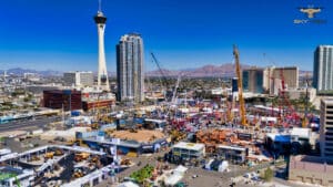
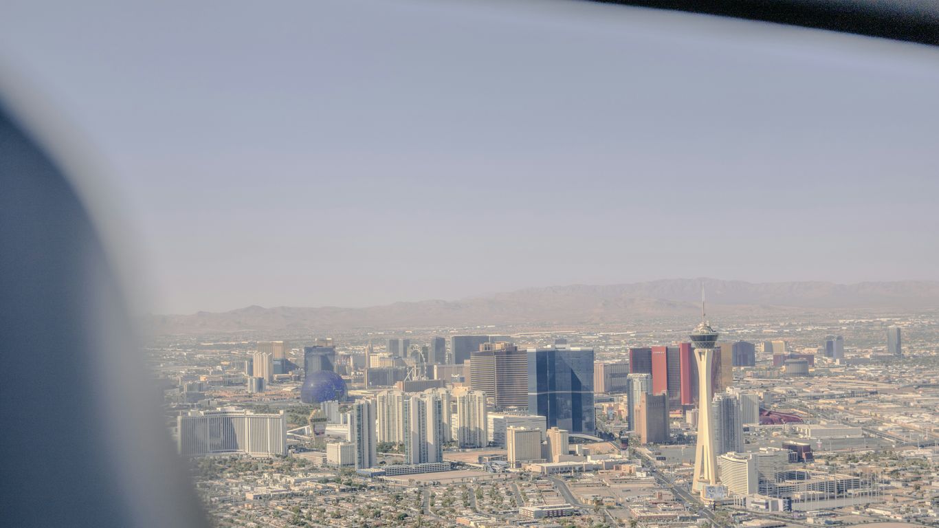
Aerial view of a large outdoor construction expo in Las Vegas, with cranes, equipment displays, crowds, and city buildings—including the Stratosphere Tower.
Construction Services and Progress Documentation
Construction companies have discovered that drone inspections offer safer, faster alternatives to traditional methods. Rather than sending workers onto rooftops or scaffolding, aerial inspections can quickly and thoroughly document conditions. Regular flyovers for construction progress monitoring create a visual timeline that is invaluable for stakeholder progress updates and dispute resolution.
Solar inspections represent another growing application, where thermal-equipped drones can identify failing panels across vast arrays in a fraction of the time it would take manual inspection. Agricultural drones serve similar purposes for large-scale farming operations, monitoring crop health and irrigation effectiveness across thousands of acres.
Beyond Pretty Pictures: The Tangible Business Impact
This approach delivers more than just aesthetic appeal; it drives real results. For instance, websites with compelling video content see visitors stay significantly longer, a key signal to search engines that your site is valuable. In fact, adding professional video to your pages can increase organic search traffic by over 150%.
The return on investment becomes clear when you consider:
Increased Engagement: Aerial content on social platforms consistently generates higher interaction rates. A dynamic FPV drone fly-through of your space, complete with professional background music and sound effects from our editing services team, is far more likely to be watched and shared than another static photo.
Stronger Brand Identity: Using drone photography in Las Vegas positions your business as modern and professional. It communicates a level of quality and attention to detail that customers notice.
A True Competitive Edge: While your competitors are taking photos from the sidewalk, you can provide a view that encompasses your location, the surrounding community, and the unique energy of your establishment against the iconic Las Vegas backdrop.
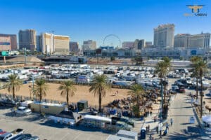
Aerial view of the Masters Tour event at the Rio Hotel and Casino with the Las Vegas skyline and High Roller Ferris wheel in the background.
Event Coverage and Live Productions
Event productions benefit enormously from aerial perspectives. Whether you’re hosting a corporate gathering, a product launch, or a community festival, drone footage in event coverage captures the scale and energy in ways ground cameras cannot. Some productions even use live broadcasting via wireless video transmission, allowing real-time aerial views during the event.
For automotive sports events and high-speed chase sequences in commercial productions, specialized cable-cam pilots can capture dynamic tracking shots that follow the action. This level of production value was once reserved for major film studios; now it’s accessible to businesses of all sizes.
Working with Skilled Pilots and Licensed Operators
Not all drone services are created equal. The difference between amateur footage and professional aerial cinematography comes down to the people behind the controls. Part 107 certification is the legal minimum, but true expertise requires hundreds of flight hours, artistic vision, and technical knowledge.
Professional, skilled pilots understand how to maximize flight time while capturing the shots you need. They know how to work within max speed limitations while still creating dynamic movement. Many also offer pilot coaching for businesses interested in developing in-house capabilities, though most find that outsourcing to specialists delivers better results at lower total cost.
At Sky View LV, we’ve helped local retailers, hospitality venues, and real estate agents transform their marketing with this exact strategy. We provide the tools and expertise to capture visuals that make a measurable difference, turning a marketing expense into a direct investment in brand growth. Our work spans everything from simple property shoots to complex commercial productions requiring ProRes RAW delivery for post-production flexibility.
The Choice: Blend In or Stand Out?
You can continue creating the same ground-level content as everyone else, hoping that a clever caption or a lucky hashtag will finally get you noticed. Or you can decide to rise above it.
The Las Vegas market is crowded, but the sky is wide open. Choosing to ignore the potential of a new perspective means remaining part of the noise. Taking action means giving your business the visual authority it deserves.
Ready to see your business from a new point of view? Contact Sky View LV today for a consultation. Let’s discuss how expert drone photography in Las Vegas can make your brand the one everyone looks up to.
Sky-High Precision- Revolutionizing Construction Projects with Drone Imaging
In the ever-evolving construction landscape, embracing cutting-edge technology has become imperative to stay ahead. One such transformative tool is drone imaging, which is revolutionizing how construction projects are planned, managed, and executed. By providing a bird’s-eye view that traditional methods can’t match, drones are enhancing precision, efficiency, and safety in the construction industry.
Transforming Traditional Project Management
Drone imaging is a game-changer in project management. By capturing high-resolution aerial images and videos, drones offer detailed site overviews that are crucial for accurate planning and monitoring. According to Construction Dive, utilizing drone technology can reduce project time by up to 20% and decrease labor costs by up to 25%.
Enhanced Planning and Design
Incorporating drone imaging in the planning phase allows for:
Accurate Site Surveys: Drones can quickly survey large areas, providing precise topographical maps and 3D models to inform design decisions.
Efficient Resource Management: By obtaining detailed visuals, project managers can better allocate resources and materials, reduce waste, and optimize logistics.
During the construction phase, drone imaging provides continuous site monitoring, which enhances:
Real-Time Progress Tracking: Regular aerial updates keep the project on schedule, enabling swift responses to delays or issues.
Quality Control: High-resolution images can be used to inspect work quality and compliance with design specifications, minimizing costly rework.
Ensuring Safety and Compliance
Safety is paramount in construction, and drones play a significant role by conducting routine inspections without endangering human workers. Drones can access hard-to-reach areas, providing detailed visuals that are invaluable for identifying potential hazards. As Forbes highlights, drone inspections reduce accident risk, thereby ensuring compliance with safety regulations.
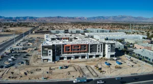
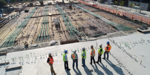
Aerial view of a modern building under construction.
Environmental Assessments
Drone imaging is instrumental in conducting environmental assessments, helping to:
Monitor Environmental Impact: Drones can track environmental changes, ensuring construction activities remain sustainable and compliant with environmental standards.
Identify Preservation Areas: Using drones, projects can be adjusted to avoid disturbing environmentally sensitive areas, promoting a greener approach to building.
Cost-Effective Construction Solutions
The integration of drone technology into construction not only enhances precision and safety but also offers cost-effective solutions. By minimizing errors and optimizing resource allocation, projects can significantly reduce overall costs. A McKinsey & Company report suggests that adopting drones in construction could save billions in annual labor and operational costs.
At Sky View LV, our commitment to excellence ensures that we leverage drone technology to deliver unparalleled service in Las Vegas. Our FAA-certified drone pilots offer expert aerial imaging solutions tailored to your project needs, from real estate to commercial developments. Experience the future of construction with Sky View LV, where innovation meets precision.
Advantages of Aerial Photography for Marketing Impact
In the competitive world of commercial real estate, capturing attention and standing out is crucial. Aerial photography in Las Vegas offers a unique perspective that can elevate your property listings and marketing strategies. By providing stunning bird’s-eye views, aerial imaging has become a game-changer for showcasing commercial properties. Let’s explore how this innovative approach can transform your business and help you stay ahead in the market.
The Power of Perspective
Aerial photography provides a comprehensive view of commercial properties that ground-level images simply cannot. Sky View LV, a leader in aerial imaging services, understands how these perspectives can make a substantial difference. Consider the following benefits:
Showcase Property Layouts: Aerial shots can capture entire property layouts, including surrounding amenities and infrastructure. This is especially beneficial for larger properties or those situated in scenic environments.
Highlight Key Features: Parking areas, landscaping, and proximity to other sites can be easily highlighted. This showcases value to potential clients who prioritize location and accessibility.
Enhancing Marketing Strategies
Incorporating aerial photography into your marketing strategy can significantly enhance the appeal of your listings. According to a NAR study, properties with high-quality images receive 118% more online views. With aerial imagery, you can:
Create Captivating Visuals: Visual content is king in digital marketing. Engaging aerial photos and videos can quickly capture attention, boosting engagement on platforms like Instagram and Facebook.
Differentiate Listings: In a saturated market, unique visuals can make your properties stand out. Aerial images intrigue potential clients and provide them with a clearer understanding of the property’s value.
Facilitating Property Assessments
Aerial photography goes beyond just marketing; it plays a crucial role in property assessments and planning. With the professional services of Sky View LV, commercial stakeholders can benefit from:
Comprehensive Overviews: Gain a full understanding of the property and its surroundings, which is crucial for investment planning and development.
Real-Time Monitoring: Track site developments and construction progress with ease. This allows for timely decision-making and ensures project efficiency.
Safety Inspections: Aerial images can be used to inspect construction sites for compliance with safety protocols, significantly reducing risk and enhancing safety protocols.
Engaging with Clients
The immersive experience provided by aerial photography can captivate potential clients. Sky View LV offers 360-degree photo spheres and Videos, allowing clients to virtually explore properties. This not only saves time but also enriches the client’s experience. Interactive content like this can lead to faster sales and rentals.
Incorporating aerial photography into your commercial real estate strategy can yield substantial benefits, from enhancing marketing efforts to aiding in property assessments. To explore how aerial imaging can transform your business, consider reaching out to Sky View LV for a free consultation. Discover the perspective elevation that awaits your properties.
Elevate Your Vision: Premier Drone Filming Services in Las Vegas. Las Vegas is a city that just begs to be seen from above. Think about it – all those lights, the sheer scale of the resorts, the endless desert surrounding it. Trying to capture that with just a regular camera feels like trying to drink from a firehose with a straw. That’s where drone filming services in Las Vegas come in. They give you that unique, sweeping view that really shows off what makes this place so special, whether for business, an event, or just to showcase a property. It’s a game-changer for visually conveying your message.
Key Takeaways
Drone filming services in Las Vegas offer amazing aerial views that really showcase the city’s unique character.
Professional drone pilots use good equipment and smart techniques to get high-quality video footage.
For real estate, drone shots make properties look much more appealing and give buyers a better sense of the place.
Businesses can use drone videos to make their brand look more professional and create marketing materials that grab attention.
Safety and following the rules are super important when flying drones for filming, and experienced pilots know how to handle this.
Capturing the Las Vegas Spectacle From Above
Las Vegas. It’s a city that practically screams for a grand, sweeping view, right? And honestly, trying to capture all that glitz and energy from the ground just doesn’t cut it anymore. That’s where drone videography comes in. It’s not just about getting a bird’s-eye view; it’s about telling a story from a perspective that was impossible just a few years ago. Think about the Strip at night, the vastness of the surrounding desert, or even the intricate details of a massive resort – drones can show it all in a way that feels both epic and intimate.
The Art of Drone Videography in Las Vegas
This isn’t your hobbyist flying a toy drone. Professional drone videography in Las Vegas is a blend of technical skill and creative vision. Pilots are trained to fly in complex environments, understanding wind patterns, airspace restrictions, and how to get those smooth, cinematic shots that make your footage pop. They use specialized equipment, such as high-resolution cameras and gimbals that keep the footage steady even when the drone is moving fast. It’s about making the impossible look effortless.
Capturing the Essence of the City
What makes Las Vegas, well, Las Vegas? It’s the lights, the scale, the constant buzz. Drone footage can really nail that. Imagine seeing the entire Strip laid out before you, the lights blurring into streaks as you fly by, or getting a sweeping shot of a major event unfolding across a huge venue. It gives you a sense of place and scale that you just can’t get any other way. It’s about showing the city’s unique character, from its iconic landmarks to its sprawling entertainment complexes. This kind of visual storytelling is perfect for promotional videos.
Advanced Techniques and Equipment
To really capture the spectacle, you need the right tools and know-how. We’re talking about drones that can fly for extended periods, carry professional-grade cameras capable of shooting in 4K or higher, and feature advanced stabilization systems that make the footage look like it came straight out of a Hollywood movie. Pilots use techniques like orbit shots, fly-throughs, and reveals to add drama and visual interest. It’s a sophisticated process that requires a deep understanding of both the technology and the art of filmmaking.
The right aerial perspective can transform ordinary scenes into extraordinary visual narratives, making your project unforgettable.
Here’s a quick look at what goes into professional drone filming:
Flight Planning: Mapping out the best routes and camera angles.
Camera Settings: Dialing in the perfect exposure and focus.
Stabilization: Utilizing advanced gimbals for smooth motion.
Data Management: Handling large video files efficiently.
It’s a lot more involved than just pointing and shooting, but the results? Absolutely stunning.
In today’s busy world, making your business stand out is tough. Professional videos play a big part in how people see your company. They show the quality and care you put into your work, leaving a good impression on clients and partners. Investing in good videography helps your brand get noticed.
Enhancing Brand Image with Professional Videos
Think about your brand’s image. High-quality videos are like a polished business card, but way more engaging. They communicate professionalism and attention to detail. When potential clients see well-produced content, they get a sense of reliability and quality. It’s not just about looking good; it’s about building trust. A strong visual presence can significantly influence how your brand is perceived. This is where professional drone filming comes in, adding a unique and dynamic perspective that ground-level shots just can’t match.
Corporate and Event Videography
For businesses, capturing corporate events or product launches with precision is key. Drone footage can add a dynamic layer to these productions. Imagine a sweeping aerial shot of your company’s annual conference or a product reveal from a bird’s-eye view. This kind of dynamic footage grabs attention and makes your event coverage more memorable. It’s perfect for marketing materials, social media, and internal communications, helping to boost engagement and reach.
Drone Filming Services in Las Vegas for Marketing
When it comes to marketing, visuals are everything. Drone videography provides a fresh angle that can make your promotional content pop. Whether you’re showcasing a new development, a commercial property, or a special event, aerial shots offer a unique perspective. This can significantly boost the appeal of your listings and marketing campaigns. For instance, real estate agents find that including aerial views makes properties more attractive, leading to more interest and faster sales. We can help you capture the essence of your project with stunning aerial views. Sky View Aerial Services can provide the high-quality footage you need to make your marketing efforts successful.
Las Vegas isn’t just about casinos and shows; it’s a hub for diverse industries that are finding new ways to work and market themselves. And guess what’s helping them do it? Drones. Seriously, these flying cameras are changing the game across the board.
Key Industries Benefiting from Las Vegas Drone Videography
It’s not just for pretty shots of the Strip anymore. Think about construction sites. Instead of just walking around with a clipboard, you can get a bird’s-eye view of the entire project. This helps spot issues early and track progress without anyone having to climb scaffolding. Real estate is another big one. Showing a property from above gives potential buyers a much better sense of the place and its surroundings. It’s like a virtual tour on steroids.
Construction Drone Footage: Detailed site surveys, progress tracking, and safety inspections.
Real Estate: Immersive property showcases, neighborhood context, and virtual tours.
Events: Capturing the scale and atmosphere of festivals, concerts, and corporate gatherings.
Tourism: Highlighting attractions, resorts, and the unique landscape of the area.
Transformative Uses in Events and Construction
For events, imagine capturing the energy of a massive festival from above. You get the whole picture – the crowds, the stage, the vibe. This kind of footage is gold for marketing future events or just creating a cool recap. In construction, it’s about efficiency and safety. Drones can map sites, assess structural integrity, and monitor progress with incredible accuracy. This saves time, reduces risk, and keeps projects on track. It’s a practical tool that makes a real difference.
The ability to see a project or event from a completely new angle provides insights that were previously impossible to obtain. This perspective shift is what makes drone technology so impactful.
Real Estate Listings Enhanced by Drone Footage
When you’re selling a home, especially a high-end one, you need to make it stand out. Drone footage does just that. It can showcase the property’s size, landscaping, pool, and how it fits into the neighborhood. It gives potential buyers a sense of the lifestyle, not just the house itself. Listings with aerial video tend to get more attention, and frankly, more serious inquiries. It’s a smart way to make your property listing pop in a crowded market.
Showcasing property boundaries and lot size.
Highlighting nearby amenities and attractions.
Providing a sense of scale and context for the property.
Creating dynamic virtual tours that engage buyers.
Getting those amazing aerial shots isn’t just about flying a drone; it’s about the gear. Professional drone setups use cameras that can shoot in super high resolutions, like 4K or even 6K. Think about cameras with big sensors and the ability to capture a wide range of colors and light – that’s what makes footage look really sharp and lifelike. Paired with these cameras are advanced stabilization systems, usually 3-axis gimbals. These gizmos work hard to keep the camera steady, no matter how much the drone moves or shakes. This means you get really smooth, fluid video, even when the drone is doing quick turns or flying through bumpy air. It’s this combination that takes footage from just okay to something that looks like it belongs on TV.
Enhancing Production Efficiency Through Advanced Drone Technology
Modern drones are packed with tech that makes filming faster and easier. Features like pre-set flight paths, which let you program the drone to fly a specific route, and precise GPS locking mean the pilot can focus more on getting the perfect shot rather than just flying the drone. Many drones also have obstacle-avoidance systems, which add a layer of safety and let the pilot be more creative. This smart technology reduces filming time and costs, ensuring every shot is consistent and high quality. It’s like having a super-smart assistant that handles the tricky flying bits so you can concentrate on the creative side.
The Importance of Post-Production Editing
Filming is only half the battle. The real magic often happens after the drone lands. Post-production is where raw footage gets polished into a finished product. This involves adjusting colors to make them pop, adding music that fits the mood, and cutting out any shaky or unnecessary bits. A well-edited video can turn amateur footage into something incredibly professional. It’s where you can really shape the story and make the visuals work with the sound to create a powerful final piece.
Mastering the technical side of drone videography means understanding not just how to fly, but also how to use the equipment to its fullest potential and then refine the captured footage. It’s a blend of piloting skill, technological know-how, and artistic editing that results in truly compelling aerial visuals.
Choosing the Right Drone Videography Partner
So, you’ve decided drone footage is the way to go for your project here in Vegas. Awesome. But with so many companies out there, how do you pick the one that’s actually going to get you what you need without a hitch? It’s not just about finding someone with a drone; it’s about finding a professional who understands your vision and can execute it safely and effectively.
Evaluating Experience and Expertise
First things first, look at how long they’ve been doing this and what kind of work they’ve tackled. A Las Vegas drone company that’s been around for a while and has a solid history of successful projects, especially in similar environments to yours, is usually a safer bet. You want someone who knows the ins and outs of aerial videography, not just someone who bought a drone last week. Think about it: would you rather have a seasoned pro or a beginner for something important?
Assessing Portfolio and Previous Work
This is where you really get to see what they can do. A strong portfolio is your best indicator of quality. Don’t just glance at it; really dig in. Check the footage’s clarity, how smooth the shots are, and whether the overall style matches what you’re looking for. Are the colors good? Is the stabilization solid, even when they’re moving the drone around? Look for variety too – have they shot different types of projects? This shows they can adapt. You can check out some examples of professional aerial videography to get a feel for what high-quality looks like.
Understanding Pricing and Packages
Costs can vary a lot, so it’s important to get a clear picture of what you’re paying for. Ask for detailed breakdowns. Does the price include editing? What about travel time? Are there different packages available based on the shoot’s complexity or the amount of footage you need? Make sure you’re comparing apples to apples when you get quotes from different places. Sometimes the cheapest option isn’t the best value if it means compromising on quality or missing key shots.
Here’s a quick look at what might be included:
Pre-production Consultation: Discussing your project goals and shot list.
Flight Planning & Site Survey: Mapping out the shoot for safety and efficiency.
On-site Filming: The actual drone operation.
Post-production Editing: Assembling footage, color correction, and adding music.
Final Delivery: Providing the finished video file.
Don’t be afraid to ask questions. A good drone service will be transparent about their process and pricing. It shows they’re professional and want to build trust with you from the start.
When you’re looking to get some amazing aerial shots in Las Vegas, the first thing you need to think about isn’t just the cool camera angles, but how to do it safely and legally. It might seem like a lot, but these rules are there for a reason – to keep everyone and everything out of harm’s way. Following regulations isn’t just a suggestion; it’s a requirement for professional work.
Understanding Drone Regulations
Before any drone takes flight for commercial purposes, there are rules to know. The Federal Aviation Administration (FAA) sets the primary guidelines for drone use nationwide. These aren’t just for hobbyists; they apply to anyone flying a drone for business, including filming. You’ll need to make sure your drone is registered and fly it within certain limits. This includes staying below 400 feet and keeping a safe distance from airports and other restricted zones. It’s all about making sure the skies are safe for everyone.
Ensuring Safety and Compliance
Safety is the top priority. This means doing a thorough check of your drone before every flight. Think of it like a pre-flight checklist for an airplane – you want to know everything is working perfectly. It also means being aware of your surroundings, keeping a safe distance from people and property, and always maintaining visual contact with your drone. This visual line-of-sight rule is pretty important. It helps prevent accidents and ensures you can react quickly if something unexpected happens.
Here’s a quick rundown of key safety points:
Pre-flight Checks: Always inspect your drone, batteries, and controller before flying.
Weather Awareness: Don’t fly in bad weather, such as high winds, heavy rain, or fog.
Situational Awareness: Be mindful of people, buildings, and other aircraft.
Emergency Procedures: Know what to do if something goes wrong.
Operating drones commercially requires a specific certification. This isn’t just a piece of paper; it signifies that the pilot has passed tests on aviation knowledge, regulations, and safe operating practices. It’s a sign of professionalism and a commitment to responsible flight.
The Role of Professional Drone Pilots
This is where having a certified professional makes all the difference. To fly drones for business in the U.S., pilots need to pass the FAA’s Part 107 exam. This certification means they’ve been tested on their knowledge of airspace, weather, drone operations, and emergency procedures. They understand the complex rules, especially around busy areas like those near Harry Reid International Airport. A certified pilot knows how to plan flights, manage risks, and operate within the legal framework, giving you peace of mind that your project is in good hands. You can find more about these requirements on the FAA drone pilot requirements page.
Here’s a look at what certification entails:
Area of Knowledge
Description
Regulations
Understanding FAA rules for commercial drone flight.
Airspace
Knowledge of different airspace classifications and how to operate within them.
Weather
Basic understanding of weather phenomena affecting flight.
Drone Operations
Best practices for safe and efficient flight, including emergency procedures.
Human Factors
Understanding physiological and psychological factors affecting performance.
Working with a pilot who holds this certification means you’re working with someone who takes safety and compliance seriously, which is vital for any professional filming project in Las Vegas.
Flying drones for jobs means following strict rules to stay safe and legal. It’s important to know and follow all the guidelines to make sure everything goes smoothly. We make sure all our operations meet these important standards. Want to learn more about how we keep things safe and by the book? Visit our website today!
Wrapping It Up
So, if you’re looking to make your next project really pop, especially here in Vegas, think about using drones. They give you a view you just can’t get any other way, whether you’re getting married, selling a house, or promoting your business. Finding the right team to handle the flying and filming is, of course, key. They know the rules, have the right gear, and can make sure you get footage that looks amazing and really captures what you’re going for. It’s a smart way to make sure your videos don’t just get seen, but remembered.
Frequently Asked Questions
What kind of events can look cooler with drone videos?
Drones can make all sorts of events look amazing! Think weddings, parties, big company gatherings, or even just showing off a cool property. The bird’s-eye view makes everything look more exciting and grand, way better than just filming from the ground.
Do I need a special license to fly a drone for videos in Las Vegas?
Yep, if you’re flying a drone to make money, like for videos, you need a special license from the FAA (that’s the Federal Aviation Administration). It’s to make sure everyone flies safely and follows the rules.
How do drone videos help sell houses?
Drone videos are awesome for selling houses. They can show off the whole property, the neighborhood, and cool features from way up high. It gives buyers a much better idea of what they’re getting and makes the listing pop!
Professional drone teams use really good drones with super clear cameras, like 4K ones. They also have special gadgets called gimbals that keep the camera super steady, so the video looks smooth and professional, even when the drone is moving fast.
How do drone shots mix with regular camera shots?
It’s all about planning and editing! Drone shots and regular camera shots can work together really well. The drone gives you the big picture or cool moving shots, and the regular camera gets the close-up details. When put together right, they tell a complete story.
You want to find a company that knows what it’s doing. Check out their past work to see if you like their style. Make sure they have experience and understand the rules for flying drones. Also, figure out what you get for your money with their different packages.
Drone Photography Services: A Key to Elevating Your Marketing.
Summary: Drone photography services use professional drone cameras to capture high-quality aerial photos. These visuals can enhance marketing by creating engaging content, increasing visual appeal, and helping your brand stand out from competitors. Imagery from drone cameras effectively highlights large spaces, showcases properties, and captures events from unique angles to attract major attention and leave a lasting impression.
Drone photography represents a strong fusion of creativity and technology, offering limitless possibilities for innovation and visual exploration. The use of drone photography services has become widespread in every industry and market in Las Vegas, USA.
Regardless of the type of business you have, drone photography serves as a valuable marketing tool. These services provide aerial shots of buildings, landscapes, and projects, as well as dynamic perspectives of events. In this blog, we will explore how drone photography can elevate your marketing approach.
What Are Drone Photography Services
Drone photography in Las Vegas, USA, involves the use of UAVs or unmanned aerial vehicles. These are commonly known as drones to capture images from elevated positions. These flying machines are equipped with high-resolution cameras that are programmed to capture stunning aerial shots and can be remotely controlled.
One of the key advantages of drone photography in Las Vegas is its ability to provide bird’s-eye views of buildings, landscapes, events, and more. This innovative form of aerial imaging offers unique perspectives and breathtaking views that are previously inaccessible.
How Drone Photography Services Can Elevate Your Marketing Efforts
You might wonder: How can a drone photography company boost my marketing results? Or what are the benefits of using drone photography for business? Well, here is your answer:
Increases Visual Appeal
One of the primary benefits of drone photography in Las Vegas, USA, for marketing is its ability to provide visuals that traditional photography simply cannot match. If you are promoting a destination, selling a property, or capturing the progress of a construction project, aerial photos offer a unique perspective.
Creates Engaging Content
If you incorporate drone footage into your marketing content, it can enhance its appeal and effectiveness. In many industries, such as hospitality, outdoor recreation, and tourism, drone photography offers a distinctive way to showcase what you have to offer. In many ways, drone photography services can take your vision to new heights in Las Vegas, USA.
Stands Out from the Competition
When you run a business, it is important to capture your target audience’s attention. Drone photography offers a solid opportunity to do just that. By showcasing aerial perspectives, you can create visually stunning content that sets your brand apart from competitors. You can uniquely feature services, products, and experiences in Las Vegas, USA, to help you stand out and make a lasting impression on potential customers.
Showcase Properties
Do you know that aerial photography services play a significant role in real estate success? Drone shots provide potential buyers with a comprehensive view of the property’s layout, the surrounding landscape, and neighborhood amenities. It adds a level of sophistication to marketing materials.
Look, aerial perspectives can create visually stunning content that drives engagement, captivates audiences, and differentiates your brand. It offers a unique opportunity to elevate your marketing efforts and leave a lasting impression on your target audience. Please always seek professional help for the best results.
Frequently Asked Questions (FAQ)
1. What makes drone photography a game-changer for marketing?
Drone photography delivers unique aerial perspectives that showcase properties, events, and products from angles impossible with traditional methods. A single drone shot can replace multiple ground photos, creating immersive 360° views that boost engagement by 300%+ on social media and websites. Businesses using drone visuals see 47% higher conversion rates in real estate listings and 68% more inquiries for hospitality promotions.
2. What types of businesses benefit most from Sky View LV drone services?
Sky View LV serves diverse industries in Las Vegas and beyond:
Real Estate: Stunning property overviews highlighting layouts, pools, and neighborhoods
Construction: Progress monitoring, site inspections, and before/after transformations
Events & Hospitality: Aerial coverage of weddings, festivals, hotels, and conventions
Marketing & Branding: Dynamic product launches, promotional videos, and social campaigns
Retail & E-commerce: Rooftop views of storefronts and inventory showcases
3. Are Sky View LV drone pilots certified and insured?
Yes! All Sky View LV pilots are FAA Part 107 certified with commercial drone licenses. We’re fully insured up to $1M per flight for property damage, liability, and equipment. This ensures peace of mind for shoots on private properties, construction sites, or public venues. Safety and compliance are our top priorities.
4. How long does a typical drone photography session take?
Sky View LV shoots take 60-90 minutes on-site, depending on project scope:
Basic property overview: 45 minutes
Multi-angle real estate: 75 minutes
Event coverage: 90+ minutes (with ground B-roll)
Construction progress: 60 minutes
We arrive 15 minutes early for pre-flight checks and provide exact timelines in every quote.
5. Do you offer editing, retouching, and post-production services?
Absolutely! Every Sky View LV package includes:
Photo retouching: Sky replacement, object removal/addition, color correction
Video editing: Stabilization, color grading, transitions, music sync, text overlays
Marketing optimization: Vertical clips for Instagram Reels/TikTok, square for Facebook
One round of revisions standard; additional edits at transparent rates
6. How does drone photography boost social media marketing?
Aerial content gets 5x more shares and 12x more comments than standard posts. Sky View LV footage:
Creates wow-factor Reels/Stories that go viral
Perfectly sized for all platforms (9:16, 1:1, 16:9)
Increases time-on-site by 200% for real estate
Drives 47% higher click-through rates in ads
7. Do you fly over private property or restricted areas?
Sky View LV secures all necessary permissions:
Property owner approval required
HOA waivers for gated communities
Event permits for public venues
No-fly zone avoidance (airports, stadiums during events)
We handle all compliance so you don’t have to.
8. Can I direct the shots or provide creative input?
Drone Revolution in Construction: A New Era in Las Vegas. So, construction is changing, right? It’s not just about hammers and hard hats anymore. Drones are increasingly appearing on job sites, and they’re making a significant difference. Think about getting a bird’s-eye view of your whole project, checking on progress without climbing scaffolding, or mapping out a site in minutes instead of days. That’s what construction drone services are all about. It’s a significant shift, and if you’re in the building industry, you’re probably wondering what all the fuss is about and whether it’s worth exploring. We’re going to break down why these flying gadgets are becoming so important.
Key Takeaways
Construction drone services are rapidly changing how building projects are managed, offering new ways to survey, monitor, and inspect sites.
Using drones can save significant time and money compared to older methods, making projects more efficient.
Drones help make job sites safer by enabling remote inspection of hazardous areas, keeping workers out of harm’s way.
The data drones collect gives a clearer picture of what’s happening on site, leading to better planning and fewer mistakes.
As this technology improves and becomes more widespread, companies that utilize construction drone services will likely have a competitive edge over those that don’t.
Okay, so construction. It’s always been a bit… traditional, right? For ages, folks in this industry have stuck to what they know, often taking their sweet time to warm up to new gadgets or methods. It’s as if they’re comfortable with the old ways, and trying something new feels like a risk that could disrupt project schedules. But then came drones. And honestly, it’s been a different story with these flying machines.
Understanding the Shift to Aerial Technology
Think about it. For a long time, getting a good look at a big construction site meant sending people out on foot, maybe with some basic equipment, or even hiring expensive helicopters for aerial shots. It was slow, sometimes dangerous, and you never quite got the whole picture. Drones changed that. They offer a quick, safe way to get eyes in the sky, capturing detailed images and data from angles we couldn’t reach before. This aerial perspective is a game-changer for planning and understanding a site.
Market Growth and Industry Adoption
The numbers clearly demonstrate the rapid pace of change. The drone market, particularly in the construction sector, has experienced significant growth. Back in 2023, the industry was already a multi-billion-dollar enterprise, and it is expected to continue growing. It’s not just giant companies jumping on board; smaller firms are also finding practical, affordable ways to use drone technology. This widespread adoption signals that drones aren’t just a fad; they’re becoming a standard part of how construction projects are managed.
So, why the sudden love affair between construction and drones? It comes down to clear advantages. Drones can survey large areas much faster than traditional methods, sometimes cutting down weeks of work to just a few days. They can get into tricky situations, provide real-time progress updates, and help keep workers out of harm’s way by conducting inspections in dangerous areas. It’s about saving time, getting better information, and making job sites safer.
The shift towards drone services isn’t just about adopting new technology for its own sake. It’s a practical response to the industry’s need for efficiency, accuracy, and improved safety. Companies that integrate these tools are finding that they can operate more efficiently and make more informed decisions.
Here’s a quick look at how quickly things are moving:
Time Savings: Tasks that used to take weeks can now be done in days.
Data Accuracy: High-resolution imagery and sensor data offer a level of detail previously unattainable.
Safety Improvements: Drones can inspect hazardous areas, reducing the need for human exposure to risk.
Cost Efficiency: Faster work and better data often translate to lower project costs.
Key Benefits of Construction Drone Services
So, why are construction companies suddenly so keen on these flying gadgets? It really boils down to a few significant advantages that make sense for the industry. These aren’t just fancy toys; they’re tools that directly impact the bottom line and how work gets done.
Unlocking Unprecedented Time Savings
Remember how long it used to take to survey a large site or check the progress on a sprawling project? Weeks, sometimes. Drones change that game entirely. A single drone operator can cover ground that would have taken a whole team days—or even weeks—to survey. This means you get the data you need much faster, allowing projects to move forward without those old bottlenecks. It’s not just about speed; it’s about getting that information when it’s actually useful, not weeks later.
Surveying: Tasks that once took weeks can now be done in a few days.
Inspections: Checking structures that once required scaffolding and days of work can now be completed in a fraction of the time.
The speed at which drone data can be collected and analyzed directly translates into quicker decision-making and fewer delays. This agility is a significant advantage in an industry where time is literally money.
Enhancing Project Accuracy and Detail
Accuracy is everything in construction. A slight miscalculation can lead to big problems and costly rework. Drones, equipped with high-resolution cameras and advanced sensors, capture incredibly detailed imagery. This enables precise measurements and a clearer picture of what’s happening on site. You can spot deviations from the plan early, obtain more accurate material estimates, and track progress with a level of detail previously impossible. This improved precision helps prevent mistakes before they occur.
Improving Worker Safety and Reducing Risk
Let’s be honest, construction sites can be dangerous places. Working at heights, navigating unstable ground, or entering tight spaces all carry risks. Drones can take on many of these hazardous tasks. Instead of sending a person up a tall building for an inspection, a drone can perform the inspection safely from a distance. Assessing risky areas or checking for hazards can be done without putting workers at risk. This focus on safety not only protects your team but also helps prevent costly accidents and project interruptions. It’s about ensuring everyone goes home safely at the end of the day, and drones play a significant role in construction safety.
Here’s a quick look at how safety is boosted:
Reduced Exposure: Workers avoid working at dangerous heights and in confined spaces.
Hazard Identification: Drones can spot potential dangers before they become issues.
Remote Assessment: Inspecting unstable or hazardous areas without direct human entry.
So, what can these flying gadgets actually do on a construction site? It’s more than just incredible aerial shots, though those are nice too. Drones are significantly changing how work gets done, making a big difference in a few key areas.
Precision Site Surveys and Detailed Mapping
Before a single shovel hits the dirt, drones can get a head start. They fly over the site and create super detailed maps, even 3D models. This is significantly faster than the old method — up to five times faster. This data helps everyone determine the best way to lay things out, identify potential issues early, and plan for features like drainage. It’s all about having a clear picture from the get-go.
Creating accurate site plans
Identifying potential challenges early
Planning for drainage and erosion control
Optimizing site layout and logistics
Real-Time Progress Monitoring
Keeping track of a project’s progress is crucial. Drones provide eyes in the sky, regularly capturing photos and videos. This means you can see exactly where things stand, show clients updates, and even help sort out payments based on the actual work done. It also creates a project history for future reference. Plus, you can spot if things are falling behind schedule before it becomes a significant problem.
Streamlining Volume Calculations and Earthwork Analysis
Figuring out how much dirt needs to be moved or how much material is in a stockpile used to be a real pain. Drones can measure these volumes with pretty high accuracy from the air. This makes planning earthmoving tasks much simpler and helps track materials on site—no more guesswork.
Comprehensive Safety Inspections
Safety is always number one, right? Drones can travel to places that might be too risky for people. They can inspect scaffolding, check hard-to-reach areas, or survey the site for hazards without putting anyone at risk. This means fewer disruptions and a safer environment for the crew. It’s like having an extra set of eyes that don’t need to worry about heights or tight spaces. You can also use them to verify that safety rules are being followed.
Drones are proving to be more than just a novelty; they are practical tools that address real-world challenges on construction sites. Their ability to collect data quickly and from unique vantage points directly impacts project efficiency and safety.
Accurate data from these flights is crucial, and some companies specialize in drone surveying services to support this effort. It’s an entirely new approach to construction projects, from start to finish.
So, you’ve got drones buzzing around your construction site. That’s great, but how do you get the most value for your budget? It’s not just about having the tech; it’s about using it smartly. Integrating drones into your regular workflow can significantly impact how your company operates, from the initial bid to the final nail.
Reducing Costs and Optimizing Resources
Consider the time and money invested in traditional methods. Surveying a large site used to take weeks. Now, a drone can accomplish a similar task in just a few days. This speed results in lower labor costs and faster project starts. Plus, you’re not burning fuel on multiple vehicles or paying for extensive scaffolding to get a look at something high up. Drones help you see exactly where materials are, how much earth needs moving, and if anything’s gone off track, so you can adjust before it becomes a big, expensive problem. It’s about using your resources more wisely.
Facilitating Clearer Communication and Collaboration
Ever had a project meeting where everyone’s looking at different blueprints or trying to describe a problem site without a clear picture? Drones change that. They capture high-resolution images and videos that anyone can view, anywhere. This makes it way easier to explain issues to clients, coordinate with subcontractors, and keep your whole team on the same page. Sharing drone data reduces misunderstandings and speeds decision-making. It’s like giving everyone a bird’s-eye view of the truth, making collaboration smoother and more effective.
Hotel Construction
Overcoming Traditional Inspection Limitations
Getting eyes on every part of a tall building or a sprawling site used to be a real headache. Workers had to climb, use lifts, or set up complex scaffolding, all of which are risky and slow. Drones can safely and quickly reach tight spots and high places. They can spot cracks, assess structural integrity, and monitor progress in areas that were previously difficult to achieve. This means you catch problems earlier and don’t have to put workers at risk. It’s a safer and more efficient way to obtain the inspection data you need. For more information on how these flying machines are changing things, visit Wispr Systems.
Faster Data Collection: Get surveys and progress reports in days, not weeks.
Reduced Risk: Keep workers out of dangerous areas.
Improved Accuracy: Make informed decisions with precise, up-to-date information.
Cost Savings: Lower labor, equipment, and material waste costs.
Using drones isn’t just about adopting new technology; it’s about fundamentally rethinking how you manage projects. It’s about making smarter choices, saving money, and keeping your people safe by seeing the whole picture from above.
Navigating the Future of Construction Drone Services
The way we build is changing, and drones play a significant role in that transformation. It’s not just about taking cool aerial photos anymore; these machines are becoming indispensable tools on job sites. The construction industry has been slow to adopt new technology in the past; however, drones are an exception. They offer clear benefits that are hard to ignore, such as saving significant time and money. In 2023 alone, the drone survey market generated over $1.3 billion, underscoring the considerable investment companies are making in this technology. It’s not just the big companies; smaller firms are also finding ways to use drones, making them accessible for projects of all sizes. Drones can access places that humans can’t easily reach, collecting essential data that helps everyone make better decisions more quickly. The market value of construction drones reached $3.9 billion in 2023 and is projected to grow at an annual rate of more than 8.5%. This shows that drones are here to stay and are fundamentally changing how we approach construction projects.
The future looks even more exciting with new developments on the horizon. We’re seeing drones that can fly and collect data autonomously, without requiring a person to constantly pilot them. Consider drones that can automatically recharge and then return to work, or those that are intelligent enough to navigate obstacles on their own—this level of automation yields even greater efficiency and reduces the risk of human error. Additionally, artificial intelligence (AI) is becoming increasingly proficient at analyzing drone-collected data. AI can identify potential on-site issues, help plan schedules more effectively, and compare what’s being built in real time to the original design plans. It’s like having an extra set of super-smart eyes on the project.
Autonomous Operations: Drones flying and collecting data with minimal human input.
AI-Powered Analytics: Smart software that interprets drone data for insights.
Advanced Sensors: New sensors for thermal imaging, ground-penetrating radar, and more.
Drone Swarms: Multiple drones working together on large sites.
Strategic Implementation for Competitive Advantage
How do you ensure your company is getting the most out of this technology? It’s not just about buying a drone; it’s about having a plan. You need to consider how drones fit into your existing workflows and what training your team will need. Companies that figure this out now will have a significant advantage over those who don’t. It’s about staying ahead of the curve. The numbers show that companies using drones have already reduced project costs by approximately 25% and accelerated surveying from weeks to just days. Ignoring this technology risks leaving you behind competitors who are already seeing these benefits. It’s essential to consider how drones enhance on-site safety, a significant concern for any construction business.
The pace of technological change means companies must actively integrate drone services to maintain a competitive edge; those who hesitate risk being outpaced by more forward-thinking rivals.
Construction
The Growing Importance of Drone Integration
As drones become increasingly intelligent and capable, their role in construction will continue to grow. We’re discussing integrating these technologies with other advanced technologies, such as virtual and augmented reality. Imagine walking through a virtual model of your construction site, updated in real time with drone data. This makes planning and collaboration much easier for everyone involved. The initial cost of drones, including hardware, software, and training, might seem high, but the long-term savings and improvements in accuracy and safety make it a worthwhile investment. It’s clear that drones are no longer a novelty; they are becoming a standard part of modern construction practices. The future of construction is looking up, quite literally.
Aspect
Traditional Method
Drone Method
Surveying Time
Weeks
1-4 Days
Cost Reduction
N/A
Approx. 25%
Data Accessibility
Limited
Real-time, detailed
Worker Risk
Higher
Significantly Lower
Drones are revolutionizing the way we build things, offering new ways to monitor projects and capture stunning views. Imagine seeing your construction site from a high vantage point, spotting problems early, and showcasing progress with gorgeous pictures and videos. This technology enables the creation of more innovative and safer buildings. Want to see how drone services can help your next project? Visit our website to learn more and get a free quote!
Wrapping It Up
We’ve discussed extensively how drones are transforming the job site. They’re not just a passing trend. From saving us time and money to keeping folks safer up on the scaffolding, these flying gadgets are making a real difference. Companies that adopt them now will gain a competitive advantage. It’s not really a question of whether you should get on board with drone tech, but more about how and when you’re going to do it. The future of building is looking up, and drones are definitely a big part of that.
Frequently Asked Questions
What exactly are drones, and why are they useful in building projects?
Drones are essentially small, flying cameras that operate without a pilot. In construction, they’re invaluable because they can fly over a site and capture photos or videos from a high vantage point. This helps people visualize the entire project, track progress, and ensure everything is on track. They can reach places that are difficult for people to access, making jobs safer and more efficient.
How can drones help save time and money in construction?
Imagine having to walk around a vast building site every day to see what’s happening. It takes a lot of time! Drones can do that in minutes. They can also measure piles of dirt much faster than by hand. Because jobs are completed more efficiently and fewer people are required for specific tasks, companies save significant money on labor and materials.
Are drones safe to use on construction sites?
Yes, drones actually make construction sites safer! Instead of sending workers up high on scaffolding or into hazardous areas to inspect things, a drone can do it. This means fewer workers are placed in risky situations, helping prevent accidents. It’s like having a robot do the dangerous work for you.
What kind of information can drones collect on a building site?
Drones can collect a wide range of helpful information. They can take self-explanatory photos and videos, create detailed maps of the land, measure the amount of soil moved, and even spot issues such as cracks in structures that might be difficult to see from the ground. This information helps everyone involved in the project make better choices.
Is it challenging for construction companies to adopt drones?
It used to be a bit tricky, but it’s getting much easier now. Some companies specialize in helping construction businesses use drones. They can help you select the right drones, train your team to operate them, and analyze the data they collect. It’s becoming a standard tool, not just something for experts.
Will drones be used in construction for a long time?
Definitely! Drones are already transforming the way building projects are conducted, and they’re only getting better. As the technology improves, they’ll be able to do even more. Companies that currently utilize drones are gaining a competitive advantage, and most construction companies are likely to adopt them in the future to remain efficient.