Explore the future trends in aerial photography, highlighting the impact of drone technology, emerging applications, and advancements in camera capabilities.
Overview of Aerial Photography Market Trends
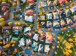
The aerial photography market has experienced remarkable growth, with a 2020 value of approximately $2.25 billion and a projected 2030 value of $8.51 billion, reflecting a compound annual growth rate (CAGR) of 14.2%. North America accounted for nearly 40% of the market in 2020, while the Asia-Pacific region is expected to grow at the fastest rate, at 16% from 2021 to 2030. As technology evolves, demand for drone photography is expected to rise, significantly impacting sectors such as urban planning, which is projected to grow at a 15.8% CAGR.
Geospatial mapping emerged as the most popular application in 2020, reflecting the growing demand for accurate, detailed spatial data. The expansion of drone technology and its applications continues to shape the market, enabling professionals across industries to leverage aerial imaging to enhance decision-making and operational efficiency.
The Impact of Drone Technology
Drone technology is revolutionizing aerial photography by providing high-definition imagery that supports real-time project monitoring and resource allocation. Innovations such as improved stabilization, longer battery life, and advanced high-resolution cameras enhance the quality of aerial shots, making them indispensable for a range of applications. For instance, LiDAR-equipped drones are now being utilized for detailed site analysis and 3D modeling, which are crucial for construction and surveying projects.
Additionally, first-person view (FPV) drones are capturing dynamic content that enhances marketing strategies, showcasing products and projects from unique perspectives. This capability not only improves brand visibility but also streamlines processes, as drone inspections can eliminate the need for traditional scaffolding, significantly reducing costs and risks while ensuring thorough evaluations of buildings or infrastructure.
Emerging Trends in Aerial Imaging
One of the most exciting developments in aerial imaging is the rise of 3D mapping, which allows for detailed visualization and clash detection in construction projects. This technology enhances project planning and execution, ensuring potential issues are identified early. Furthermore, high dynamic range (HDR) technology is being incorporated into aerial photography to enhance color and lighting, resulting in stunning visuals that capture intricate details with exceptional clarity.
The integration of artificial intelligence (AI) and machine learning is also set to transform aerial photography by enabling drones to process data more efficiently. Autonomous flight capabilities would allow drones to operate on preset paths, ensuring consistent, precise image capture. As a result, these advancements are creating immersive experiences, particularly with the rise of virtual reality applications that utilize aerial imagery for engaging storytelling and viewer interaction.
Applications Across Various Industries
Aerial photography is making significant strides in various industries. In agriculture, drones are enhancing precision in crop monitoring, enabling farmers to reduce costs by up to 85% through optimized planting and spraying. Furthermore, the real estate industry is leveraging aerial imagery to accelerate property sales: homes marketed with aerial photography sell 68% faster than those without.
Environmental monitoring is another critical application in which aerial photography helps track changes in landscapes, ecosystems, and wildlife populations. Drones are also becoming increasingly popular for capturing expansive venues and candid moments at events, providing unique perspectives that traditional photography cannot. Additionally, corporate marketing is utilizing aerial photography to showcase company activities and enhance brand narratives, further highlighting the versatility of this technology across sectors.
Future Advancements in Camera Technology
The future of aerial photography will see exciting advancements in camera technology, including 8K video capabilities and enhanced image sensors, resulting in higher-quality outputs. Drones are expected to incorporate 5G technology to enable real-time data transmission, improving the efficiency of aerial imaging.
Moreover, improvements in battery life and autonomous flight capabilities will enable drones to cover larger areas more effectively, making them even more valuable across a broader range of applications. The emergence of customizable drone solutions tailored to specific project needs will also improve decision-making and operational efficiency across industries. Innovations in low-light technology are further expanding the horizons of aerial photography, enabling breathtaking night shots that were previously unattainable.
Regulatory and Cost Challenges
Despite the promising growth of the aerial imaging market, it faces several regulatory and cost challenges that could hinder its progress. Regulatory discrepancies across regions complicate compliance and increase operational costs, making it difficult for companies to navigate the landscape effectively. Additionally, the high upfront costs of advanced drone technology limit access for small- to medium-sized businesses, potentially stifling competition and innovation in the market.
Ongoing discussions on regulatory frameworks are vital to the future growth and efficiency of aerial imaging across industries. The need for standardized regulations is becoming increasingly crucial to facilitate market growth and operational efficiency. As scrutiny of drone operations intensifies, stricter compliance requirements may also increase the overall cost of aerial photography services, posing further challenges for industry players.
Future of Aerial Photography in a Digital Age
As we look to the future, aerial photography is poised to become increasingly versatile, serving both commercial and artistic purposes as technology advances. The integration of innovative technologies promises to transform how aerial photography is utilized across various sectors, driving future growth. As demand for visual content continues to rise, aerial photography will remain a pivotal tool in marketing strategies and project management.
Collaboration between software developers and drone manufacturers is expected to yield more advanced aerial photography solutions, further enhancing the capabilities and applications of this technology. The future landscape of aerial photography will likely see increased use of drones for emergency response and disaster management, underscoring the potential of this technology to make a positive contribution to society.
In today’s competitive property and marketing landscape, aerial photography has moved from being a luxury to an essential service. Whether you’re a real estate agent showcasing a listing, a construction firm tracking site progress, or a marketing agency crafting a compelling campaign, drone photography offers a perspective that traditional methods can’t match.
This guide addresses the most frequently asked questions about drone photography services, helping you understand what to expect, how to prepare, and how to maximize your investment.
Drone photography is more than just pretty pictures from above—it’s about capturing a story that ground-level shots can’t tell.— Peter McKinnon, Professional Photographer
What is Drone Photography?
Drone photography uses uncrewed aerial vehicles (UAVs) equipped with high-resolution cameras to capture still images and video from elevated perspectives. For real estate agents, this means dramatic overhead shots of properties, sweeping neighborhood views, and unique angles that make listings stand out. For construction companies, drones deliver progress documentation, safety inspections, and site mapping without the need for expensive helicopters.
Key applications of drone photography across industries
Application
Benefit
Industry
Real Estate
Showcases property scale and surroundings
Real Estate
Construction
Tracks project progress efficiently
Construction
Marketing
Creates dynamic visual campaigns
Advertising
As shown above, the versatility of drone photography makes it applicable across many sectors.
How Do Aerial Photography Services Work?
Professional aerial photography services start with understanding your project needs. Typically, you’ll discuss your goals with the drone operator—whether it’s capturing a residential property, documenting construction milestones, or producing marketing visuals. The operator will then plan flight paths, obtain the necessary permissions, and schedule optimal shooting times based on weather and lighting conditions.
Many providers, such as SkyViewLV, use FAA-certified drone pilots to ensure compliance with all regulations. This is crucial because drone operations in commercial contexts must adhere to strict safety and legal guidelines.
What Are the Legal Requirements for Drone Photography?
In the United States, any commercial drone operation must comply with FAA Part 107 regulations. This includes pilot certification, adherence to altitude limits, and maintaining a visual line of sight during flights.
Commercial drone pilots must be certified under Part 107 and follow all operational rules to ensure safety and legality.— FAA Official, Federal Aviation Administration
Failing to follow these rules can result in fines and legal consequences. Therefore, always hire a provider who can prove their certification and understands local airspace restrictions.
How Much Does Drone Photography Cost?
Pricing varies depending on project complexity, duration, and deliverables. For real estate, single-property shoots can range from $150 to $500, while ongoing construction documentation might be priced per flight or as part of a package.
These figures are estimates; your provider will tailor pricing to your specific needs and circumstances.
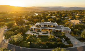
How Can Drone Photography Benefit Real Estate Listings?
Aerial visuals provide buyers with a clearer understanding of a property’s layout, lot size, and surroundings. They can highlight features such as pools, landscaping, or proximity to amenities. Studies show listings with aerial imagery receive significantly more engagement.
For example, a Las Vegas real estate agent used drone shots to showcase a luxury home with panoramic desert views. The property sold 30% faster than comparable listings without aerial imagery.
Can Drones Be Used for Indoor Photography?
Yes, but with limitations. Smaller drones equipped with obstacle avoidance can capture unique indoor footage, especially in large commercial spaces or construction interiors. However, indoor flights require careful planning to avoid safety hazards.
How Long Does a Drone Shoot Take?
A typical real estate drone shoot might take 1-2 hours, including setup and multiple flight passes. More complex projects, like construction site mapping, may require half a day or more.
Weather is a significant factor—wind, rain, and poor lighting can delay flights. Professional providers monitor forecasts to schedule optimal shooting windows.
What Should I Prepare Before a Drone Shoot?
Ensure property access and permissions.
Remove obstructions or hazards.
Communicate desired shots and angles.
Schedule around the best lighting conditions (early morning or late afternoon)
Preparation helps maximize efficiency and ensures the final product meets your expectations.
How Is Drone Photography Delivered?
Most providers deliver high-resolution JPEG or RAW images and HD/4K video files via secure download links. Edited versions may include color correction, stabilization, and branding elements for marketing purposes.
Future Trends in Drone Photography
Emerging technologies, such as AI-based image analysis, automated flight planning, and live-stream capabilities, are expanding the ways drones are used. For construction, drones may soon provide real-time 3D modeling of sites. In marketing, expect more interactive aerial content integrated into virtual tours.
SkyViewLV, for example, specializes in real estate, commercial, and marketing drone photography in Las Vegas, combining technical expertise with creative vision.
Their aerial shots transformed my business listing from ordinary to extraordinary—it sold within weeks.THANK YOU— Jane Lattori, SkyViewLV Client
Conclusion
Drone photography is a powerful tool for real estate agents, construction companies, and marketing professionals. It offers unparalleled perspectives, enhances storytelling, and delivers measurable results. By understanding the FAQs outlined here—covering legal requirements, costs, benefits, and best practices—you can confidently integrate aerial imagery into your projects.
If you’re ready to elevate your visuals, consider partnering with an experienced, certified provider like SkyViewLV. The sky isn’t the limit—it’s the starting point for your next great project.
Elevating Las Vegas: The Art of Professional Drone Aerial Photography
Las Vegas is a city that demands to be seen from above. From the iconic Strip’s neon brilliance to the stunning natural beauty of Red Rock Canyon, our desert metropolis offers some of the most spectacular aerial views in the world. At Sky View LV, we’ve made it our mission to capture these breathtaking perspectives through professional drone aerial photography, transforming ordinary projects into extraordinary visual experiences.
The Sky View Difference: More Than Just Flying Cameras
When most people think of drone photography, they imagine hobbyists with small quadcopters taking vacation snapshots. Professional Drone Aerial Photography is a distinct field—one that requires technical expertise, artistic vision, and rigorous safety protocols.
Our team of FAA Part 107-certified pilots doesn’t just operate drones; we craft aerial narratives that tell your story from a perspective once available only to Hollywood productions with massive budgets. Whether you’re a real estate agent showcasing a luxury property, an event planner documenting a wedding, or a business owner creating marketing content, we understand that every shot needs to serve a purpose.
Las Vegas: A Drone Photographer’s Paradise
Las Vegas presents unique opportunities and challenges for aerial photography. The city’s dramatic contrasts—from urban sophistication to rugged desert landscapes—create endless possibilities for stunning visuals. Our local expertise enables us to capture the perfect shot precisely when and where it matters.
Urban Brilliance
The Las Vegas Strip transforms throughout the day, offering distinct moods and energy levels. Our Drone Aerial Photography captures the city’s pulse, from the golden-hour glow reflecting off hotel facades to the electric energy of night scenes, with thousands of lights painting the desert sky. See Vegas from above.
Natural Beauty
Beyond the neon, Las Vegas is surrounded by some of Nevada’s most beautiful natural landscapes. Red Rock Canyon, Lake Las Vegas, and the Spring Mountains provide dramatic backdrops that elevate any project from ordinary to extraordinary.
Architectural Marvels
From luxury resorts to cutting-edge residential developments, Las Vegas architecture is designed to impress. Our aerial perspective showcases the scale, design, and craftsmanship that ground-level photography cannot capture.
Industries We Serve
Real Estate Excellence
In Las Vegas’s competitive real estate market, Drone Aerial Photography isn’t just a luxury—it’s essential. Our aerial shots showcase property boundaries, neighborhood amenities, and surrounding landscapes, helping potential buyers truly understand what they’re considering. Whether it’s a sprawling Summerlin estate or a high-rise condo with Strip views, we capture the full story of your property.
Event Documentation
Las Vegas hosts thousands of events annually, from intimate weddings to massive corporate gatherings. Our drone photography captures the scale, beauty, and energy of these occasions, providing unique perspectives that ground-based photographers miss entirely.
Commercial and Marketing
Businesses across Las Vegas trust our Drone Aerial Photography to elevate their marketing materials. Construction companies document progress, restaurants showcase their locations and outdoor spaces, and entertainment venues capture the excitement and scale of their offerings.
Film and Media Production
Las Vegas’s growing film and media industry relies on our expertise to capture establishing shots, provide unique angles, and create content that meets professional broadcast standards.
Technical Excellence: The Tools Behind the Magic
Professional Drone Aerial Photography requires more than just flying a drone and pressing the record button. Our equipment arsenal includes:
5K Ultra HD Cameras: Every shot is captured in stunning detail, ensuring your content looks professional across all platforms
Stabilized Gimbals: Smooth, cinematic footage that rivals traditional helicopter shots
Professional Editing Suite: Color correction, stabilization, and creative editing that transforms raw footage into polished content
Weather Monitoring Systems: Safety and quality depend on optimal flying conditions
Safety and Compliance: Flying by the Rules
Operating drones commercially in Las Vegas requires strict adherence to FAA regulations, local ordinances, and safety protocols. Our Part 107 certification demonstrates our understanding of controlled airspace, weather limitations, and safety procedures that protect people and property.
Las Vegas’s proximity to McCarran International Airport (now Harry Reid International Airport) and Nellis Air Force Base creates a complex airspace that requires expert navigation. We handle all the necessary permits and clearances, ensuring your project proceeds smoothly and complies with all relevant regulations.
The Creative Process: From Concept to Delivery
Every Drone Aerial Photography project begins with understanding your vision. We work closely with clients to identify key shots, optimal timing, and creative approaches that align with their specific goals.
Pre-Production Planning
We scout locations, check weather forecasts, obtain necessary permits, and create detailed flight plans that maximize safety and creative potential.
Production Day
Our experienced pilots execute the planned shots while remaining flexible to capture unexpected opportunities that arise during filming.
Post-Production Excellence
Raw footage is transformed through professional editing, color correction, and creative enhancement, ensuring your final product exceeds expectations.
Quality Drone Aerial Photography represents an investment in your project’s success. Our custom packages are designed to deliver maximum value while meeting your specific needs and budget.
Factors that influence pricing include:
Project complexity and duration
Number of locations
Required permits and clearances
Post-production requirements
Delivery timeline
We provide transparent, upfront pricing with no hidden fees, ensuring you understand exactly what’s included in your package.
As Las Vegas continues to grow and evolve, Drone Aerial Photography will play an increasingly important role in documenting and promoting our city’s development. New technologies, including advanced sensors and AI-assisted flight systems, promise even more creative possibilities in the years ahead.
At Sky View LV, we’re committed to staying at the forefront of these innovations while maintaining the personal service and attention to detail that sets us apart.
Ready to Elevate Your Project?
The difference between amateur drone footage and professional Drone Aerial Photography is immediately apparent to viewers. When your project demands excellence, trust the certified professionals at Sky View LV to deliver results that soar above your expectations.
Contact us today to discuss your vision and discover how our aerial expertise can transform your project:
Email: sk*******@***il.com
Website: https://skyviewlv.com/
Service Areas: Las Vegas, Henderson, Summerlin, and surrounding Nevada communities
Exploring the Future: How Las Vegas Drones are Transforming the City Landscape. Las Vegas isn’t just about casinos, bright lights, and entertainment anymore. The city is becoming a hub for innovation—and drones are playing a significant role in that transformation. From revolutionizing construction projects to enhancing tourism, supporting emergency services, and even helping with environmental conservation, drones are changing the way Las Vegas operates.
Here’s a closer look at how drones are reshaping the city from above—and what it means for the future.
🚀 Why Drones Are Taking Off in Las Vegas
Las Vegas has always embraced bold ideas. Now, drones are helping the city soar to new heights. These flying marvels are no longer just for hobbyists—they’re tools for business, safety, creativity, and sustainability.
Key Benefits of Drone Use in Las Vegas:
Improved efficiency in construction and urban planning
Enhanced tourism experiences through aerial views and virtual tours
Faster, safer emergency responses
Better environmental monitoring and conservation
A growing industry that creates jobs and attracts investors
The Rise of Las Vegas Drones Companies in Urban Development
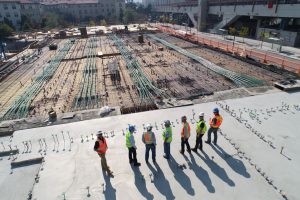
Real-Time Project Monitoring
Construction is booming in Las Vegas, and drones make it easier to manage the work. Project managers can track progress from above, spot delays, and make real-time decisions. This means fewer costly setbacks and safer job sites.
City planners use drone data to make smarter, more sustainable choices. Drones map land, monitor environmental conditions, and help design future developments that work better for everyone.
🌆 Elevating Tourism and Entertainment with Las Vegas Drones
Capturing Iconic Views
The Las Vegas Strip, Bellagio Fountains, and Red Rock Canyon—these are all breathtaking from above. Drones provide never-before-seen perspectives that attract millions online and inspire travelers to visit—drone Operators in Las Vegas.
Virtual Tours for Global Audiences
Drones are making it easy to explore Las Vegas from anywhere in the world. Virtual tours powered by drone footage help tourists plan trips, book hotels, and experience the excitement before they even land.
Boosting Marketing Strategies
Companies like Sky View LV are leading the way in drone-powered content. They deliver cinematic-quality aerial videos that make events, properties, and businesses stand out from the competition.
Rapid Response and Situational Awareness
In emergencies, every second counts. Drones help first responders assess dangerous situations from the air—whether it’s a fire, accident, or natural disaster—before they arrive on scene.
Search and Rescue Made Smarter
In the vast deserts surrounding Las Vegas, drones can cover more ground faster than humans. Equipped with heat sensors and night vision, they can locate missing persons and even drop essential supplies.
Enhancing Event Security
Large crowds at concerts, festivals, and conventions require innovative security solutions. Drones monitor activity from above, alerting authorities to potential issues and improving overall public safety.
Enhancing Public Safety Measures
Public events in Las Vegas, from concerts to conventions, attract large crowds. Ensuring safety in these environments is a top priority. Drones provide an extra layer of security by monitoring crowds and detecting unusual activity from above. With their bird’s-eye view, they can spot potential threats or disturbances that might go unnoticed by ground personnel. The Las Vegas Metropolitan Police Department is a prime example of how small unmanned aerial systems enhance public safety and support law enforcement. By integrating drones into their operations, they can respond more effectively to incidents, ensuring a safer environment for everyone.
🌿 Protecting the Environment from the Sky- The Role of Las Vegas Drones
Wildlife Monitoring
Drones are helping researchers observe wildlife and habitats without disturbing them. This is especially valuable in delicate ecosystems or hard-to-reach areas near the city outskirts.
Tracking Environmental Changes
Las Vegas is constantly growing, and drones are documenting the environmental impacts. They help track pollution, land use, and water resources—providing data to guide sustainable development.
Promoting Sustainability
By identifying environmental threats early, drones enable conservation teams to respond more quickly. This leads to more effective cleanup efforts, restoration projects, and resource allocation.
Advancements in Las Vegas Drone Technology
AI and Autonomous Flight Innovations
In Las Vegas, drones are becoming increasingly intelligent thanks to advancements in AI and autonomous flight capabilities. These advancements mean drones can fly and make decisions without constant human control. Imagine drones that adjust their flight paths to avoid obstacles or automatically follow a moving target. This tech is a game-changer for industries like construction and emergency services, where quick and precise actions are crucial- thanks to drone Technology.
High-Resolution Imaging
With 4K and 8K capabilities, drones capture stunning visuals ideal for real estate, tourism, and scientific research. High-res data is also crucial for inspections and decision-making.
What’s Coming Next?
Expect longer battery life, more powerful sensors, and new use cases—such as drone deliveries or automated firefighting. Las Vegas is already positioning itself as a leader in next-gen drone innovation.
💼 Economic Growth: Jobs, Startups, and Investments-The Impact of Las Vegas Drones
Creating New Careers
The drone industry is creating demand for pilots, technicians, software developers, and data analysts. Local training programs and certifications are helping people enter this fast-growing field.
Cutting Costs for Businesses
Drones are more affordable than helicopters or large crews for inspections, filming, and surveying. That means companies save money—and get better results.
Attracting Investors
With new startups and services emerging, Las Vegas is attracting venture capital and tech investment. The city is quickly becoming a hotspot for drone entrepreneurship.
📜 Regulations and Responsible Drone Use
FAA Rules to Know
To fly a drone commercially, operators must have an FAA Part 107 license. There are also airspace restrictions—especially around the airport and parts of the Strip.
Privacy and Data Security
Drone pilots must respect privacy by avoiding unauthorized surveillance and protecting the data they collect. As drones become more common, security protocols are essential.
Local Policies in Progress
Las Vegas is working on local regulations that support innovation while maintaining public safety. Expect more explicit rules around drone zones, permits, and public event usage.
Drones in Las Vegas face many rules and challenges, but there are ways to work around them. Understanding these regulations is key to safe and effective drone use. To learn more about navigating these challenges, visit our website for helpful tips and services!
✨ Conclusion: A City on the Rise—From the Sky
Las Vegas is flying into the future—literally. Las Vegas Drones are changing how the city builds, entertains, protects, and grows. They’re not just gadgets; they’re essential tools that are shaping a smarter, safer, and more visually stunning Las Vegas.
As technology continues to evolve, the possibilities are endless. And if there’s one place that knows how to turn potential into spectacle, it’s Las Vegas.
❓ Frequently Asked Questions (FAQ)
What are drones used for in Las Vegas? Drones are used for construction monitoring, real estate marketing, tourism videos, emergency response, wildlife tracking, and environmental studies.
Why are drones popular in Las Vegas? They provide unique aerial views of the city’s landmarks, boost tourism, enhance safety, and help businesses operate more efficiently.
Do I need a license to fly a drone in Las Vegas? Yes—commercial drone operators need an FAA Part 107 license. Recreational users must also follow strict airspace rules.
Are drone services safe? Yes, when operated by licensed professionals who follow regulations and use secure technology.
What should I look for in a drone company? Choose a provider with FAA-certified pilots, positive reviews, proper insurance, and a strong portfolio of past work.
📌 Want to learn more about drone services in Las Vegas? The Best Las Vegas Drone Company Contact our team or explore our blog for tips, news, and expert advice on getting started in the drone industry.
Drone Services in Las Vegas: Taking your Vision to New Heights. Las Vegas isn’t just about the bright lights and high-energy entertainment—it’s also a hub for cutting-edge drone technology. Whether you need jaw-dropping aerial photos, detailed property inspections, or precision data for agriculture, drone services in Las Vegas are here to deliver. With certified pilots, top-tier gear, and a deep passion for what they do, these experts are ready to bring your vision to life—from the sky.
🚁
✨ Why Choose Drone Services in Las Vegas?
Here’s what sets Vegas apart when it comes to drone services:
📸 Stunning photography and videography for real estate, events, and more
🏗️ Reliable inspections and mapping for construction and engineering
🌱 Precision monitoring and support for agriculture
✅ Certified, insured pilots who prioritize safety and quality
🎓 Training programs for aspiring drone pros
🖥️ High-quality editing and post-production for polished, professional results
📷 Aerial Photography & Videography That Tells a Story
Whether it’s a sweeping cinematic shot for a film or an overhead view of a real estate listing, our drone operators know how to capture the perfect angle. Our team blends advanced technology with creative vision to produce content that’s as impactful as it is beautiful.
From large-scale TV shoots to search and rescue ops, no project is too big—or too small.
🏠 Real Estate, Elevated
Want to showcase a property like never before? Drone services bring out the best in real estate—literally.
From wide-angle views of expansive estates to detailed flyovers of commercial developments, drone photography helps listings stand out and sells homes faster. Local companies like Sky View LVspecialize in providing buyers with a fresh perspective—safely and professionally.
Construction
🏗️ Drones in Construction & Engineering
Here’s how drones are reshaping the job site:
📍 Site Surveys & Mapping
Capture detailed topographic maps and 3D models to streamline planning and reduce guesswork.
📊 Progress Tracking
Track milestones visually with regular aerial updates, perfect for sharing with stakeholders and clients.
🔍 Safety Inspections
Keep your team safe by using drones to inspect hard-to-reach or hazardous areas—no scaffolding or risk required.
In short, drones make construction smarter, faster, and safer.
🎉 Drones for Events & Celebrations
Turn any event into something unforgettable with stunning aerial footage:
💍 Weddings & Special Occasions
Imagine a bird’s-eye view of your big day—your ceremony, venue, and guests captured in cinematic style.
🏢 Corporate Events
Drones can capture significant events such as product launches, conferences, and company parties, providing professional visuals for promotion or keepsakes.
🏃 Sports & Outdoor Activities
From races to games, drones capture all the action—up close and from every angle.
Whether it’s personal or professional, drone footage adds that “wow” factor.
🌾 Smarter Farming with Drone Tech Mapping
Agriculture is going high-tech—and drones are leading the way.
🌿 Crop Monitoring
Identify stressed areas early with multispectral imaging to respond quickly and improve yields.
💧 Irrigation Management
Drones help visualize water distribution, enabling the development of more intelligent, efficient irrigation systems.
🐛 Pest & Disease Detection
Quick aerial surveys help catch issues before they spread—saving time, money, and crops.
Modern farming is about precision, and drones enable it.
✅ Certified, Insured & Safety-First
Our pilots are FAA Part 107 certified, meaning they’ve passed rigorous testing and understand all the legal and safety requirements for commercial drone operations.
🛡️ We’re Fully Insured:
$2M in commercial UAV insurance
$2M in privacy protection
$2M in general liability & workers’ comp
🔒 We Follow Strict Safety Protocols:
Night flight approvals
Operations over populated areas
Redundant systems and safety checks on every flight
We don’t cut corners—we’re professionals who take pride in what we do, and safety always comes first.
Drone training
🎓 Learn to Fly with Drone Training Programs
Interested in flying drones professionally—or just for fun? We’ve got you covered.
🚀 Beginner Classes
Learn how to fly safely and confidently with hands-on practice and expert instruction.
🎯 Advanced Maneuvers
Take your skills to the next level with advanced flight techniques, obstacle navigation, and camera control.
Get ready to pass the FAA certification with in-person or online training, study materials, and personal coaching.
Whether you’re exploring a new hobby or launching a new career, our training programs are a solid first step.
🌟 Let’s Take Off Together
Drone services in Las Vegas are transforming how we see and interact with the world. From real estate and construction to agriculture and events, the possibilities are endless—and growing every day. Sky View Las Vegas Unveils Cutting-Edge Drone Photography Services
With certified pilots, modern equipment, and a love for flying, we’re here to help bring your vision to life, one flight at a time.
🙋♂️ Frequently Asked Questions
What drone services are available in Las Vegas? Everything from real estate and construction surveys to event coverage, cinematic shoots, and agricultural monitoring.
Are drone pilots certified? Yes! All our pilots are FAA Part 107-certified and trained for safe, legal operations.
Do drone services come with insurance? Absolutely. We carry $2M+ in liability, aviation, and privacy coverage.
How fast can I get my footage? Most projects are delivered within 24-48 hours thanks to our in-house editing team.
Is drone training available in Las Vegas? Yes! We offer hands-on beginner and advanced courses, as well as FAA exam preparation.
Drone Operator
Ready to get started? Let’s elevate your project. Visit our website or reach out today to learn more about how drone services in Las Vegas can work for you!
🛫 Let’s Take Your Project to the Next Level
Whether you’re a real estate agent looking to capture the perfect listing shot, a construction manager needing detailed site data, or a couple wanting unforgettable footage of your wedding day, Professional Drone Services in Las Vegas offer something for everyone.
We don’t just fly drones—we tell stories, solve problems, and help you see things from a whole new perspective.
Here’s why clients keep coming back:
✅ Clear communication and personalized service
🚀 Fast turnaround times with pro-level editing
🎥 High-quality footage shot with industry-leading drones
🔐 Full insurance coverage and FAA compliance
💡 Creative solutions for unique projects
From first contact to final delivery, we’re with you every step of the way.
📞 Ready to Fly? Let’s Chat!
If you’re curious about how drones can support your goals—whether business or personal—we’re happy to answer your questions.
👉 Get in touch for a free consultation We’ll walk you through what’s possible, what’s needed, and what it will take to bring your vision to life.
No problem! Here are a few ways you can use our drone services right now:
🌆 Real estate agent? Book a drone shoot for your latest listing.
🛠️ In construction? Request a quote for a site survey or progress video.
💍 Planning a wedding? Let’s talk about an aerial highlight reel.
🌿 Farming or land management? Set up a crop health scan.
🧑🎓 Interested in flying drones yourself? Sign up for our next training session!
Whatever your idea, we’re here to make it happen—with the gear, the team, and the experience to do it right.
✈️ Final Thoughts
Drone technology has come a long way—and Las Vegas is at the forefront of this aerial revolution. With certified professionals, versatile services, and creative applications across industries, there’s no limit to what you can accomplish from above.
So whether you’re chasing the perfect photo, need high-accuracy data, or want to kickstart a career in drone piloting, the sky truly is the limit.
Let us help you see your world from a higher perspective.
Things to Consider When Hiring a Drone Pilot. Drones are no longer just high-tech toys for hobbyists—they’ve become powerful tools in industries like photography, real estate, construction, agriculture, and more. Whether you’re looking to capture sweeping aerial footage for a promo video or need a bird’s-eye view for a site survey, hiring the right drone pilot can make or break your project.
But not all drone operators are created equal. So, how do you find someone who’s qualified, experienced, and the right fit for your needs? Let’s break it down.
Finding a certified drone pilot in Las Vegas.
Why Hiring the Right Drone Pilot Matters
Drones offer a unique perspective and unmatched versatility, but operating one professionally requires more than just flying skills. A good drone pilot knows the legal landscape, understands how to capture high-quality visuals, and—most importantly—knows how to do it all safely.
Whether you’re hiring for a simple sightseeing tour or a complex commercial shoot, taking the time to choose the right pilot will save you time, money, and a lot of headaches.
1. Check Their Qualifications and Licensing
First things first: make sure they’re certified.
In the U.S., any drone pilot offering services commercially must hold an FAA Part 107 Remote Pilot Certificate. This proves they understand airspace regulations, weather effects, emergency procedures, and safety protocols.
Tip: Don’t just take their word for it—ask to see their license. If they can’t provide it, move on.
2. Look at Their Experience
Experience matters, especially when your project involves complex environments such as urban areas, construction zones, or adverse weather conditions. You want someone who’s handled similar projects before and knows how to adapt on the fly—literally.
Also, consider the nature of your project. Do they specialize in real estate? Events? Inspections? Not all drone work is the same, so it’s essential to find a pilot who’s done what you need.
A picture is worth a thousand words—and in this case, probably a few hundred dollars—Drone Pilot in Las Vegas.
Request samples of their previous work. A strong portfolio will give you a good sense of their visual style, camera skills, and creativity. Look for quality, consistency, and versatility. Bonus points if they’ve worked on projects similar to yours.
4. Ask for References
Former clients can provide valuable insights into how drone pilots operate. Were they professional? Punctual? Easy to work with? Did they deliver what was promised?
Don’t hesitate to reach out and ask about their experience. It could help you avoid costly mistakes.
Drone
5. Understand the Equipment They Use
Not all drones are created equal. Some are ideal for cinematic video, while others are better suited for mapping or thermal imaging. Ask what kind of drone and camera gear they use—and make sure it aligns with your needs. Drone Pilots in Las Vegas
Also, confirm that their equipment is up to date. Drone technology evolves rapidly, and using outdated hardware may limit what’s possible in your project.
6. Prioritize Safety and Legal Compliance
Safety isn’t optional—it’s essential.
A responsible drone pilot should adhere to all local laws, airspace regulations, and safety protocols. They should also be familiar with the rules and regulations governing where and when they can fly, especially when shooting near airports, populated areas, or national landmarks.
And don’t forget about insurance. Accidents can happen, even with experienced pilots. Liability insurance is a smart (and sometimes necessary) safety net—for both you and the pilot.
7. Make Sure They’re Good Communicators
Even the best pilot won’t be much help if they can’t understand what you need. Look for someone who listens attentively, asks thoughtful questions, and communicates effectively. If your project involves collaborating with other professionals, such as photographers, videographers, or contractors, the pilot should work well as part of a team.
8. Discuss Availability and Scheduling
Drone pilots are often booked in advance—especially the good ones. So if you have a strict timeline or need them for an extended project, bring this up early.
If you’re working remotely, you may need to hire someone from another city. In that case, be ready to cover travel or relocation costs as part of the deal.
9. Talk Budget Early
Price will naturally play a role in your decision, but don’t let it be the only factor—Drone Pilot in Las Vegas.
Some pilots charge by the hour, while others offer flat-rate packages. Get quotes, compare them, and assess the value you’re getting. The cheapest option might not consistently deliver the best results—especially if the work is rushed or done with outdated equipment.
10. Read Reviews and Do Some Background Checking
Online reviews, ratings, and testimonials can provide valuable insights. Look for consistency in positive feedback. Are clients saying the same things—like “reliable,” “great quality,” or “easy to work with”? That’s a good sign.
Watch out for red flags, such as missed deadlines, communication issues, or unclear deliverables.
11. Make Sure They Know the Area
Local knowledge is essential for commercial or regulated flights. A drone pilot should be familiar with local airspace rules, restricted zones, and privacy laws.
Some areas may require special permits or waivers, so you want someone who’s not only aware of the law but also knows how to work within it.
12. Don’t Overlook Ethics and Privacy
Ethics matter—especially when drones are involved.
A professional pilot should understand the importance of respecting people’s privacy and following ethical guidelines. If your project involves sensitive data, aerial mapping, or shooting near private property, ensure your pilot has protocols in place to handle and protect that information.
Wrapping It Up: Finding the Right Fit
Hiring a drone pilot in Las Vegas isn’t just about finding someone who can fly a drone—it’s about finding the right person for your specific job.
Here’s a quick recap of what to look for:
✅ Proper licensing and documentation
✅ Relevant experience and a solid portfolio
✅ Clear communication and professionalism
✅ Quality equipment and tech
✅ Safety, insurance, and legal compliance
✅ Strong references and a good reputation
✅ Availability and understanding of your location
✅ Fair, transparent pricing
Whether you’re planning a one-time shoot or a long-term project, taking the time to vet your drone pilot can save you a lot of hassle—and help you get the stunning results you’re after.
Need help finding a certified drone pilot? If you require any aerial photography in Las Vegas, don’t hesitate to get in touch with us at Sky View LV https://skyviewlv.com/ 702.670.1967
Explore the Top Professional Aerial Photography Services
Aerial photography has taken off—literally. With the rise of drone technology, industries such as real estate, film, construction, and inspections are increasingly relying on these advanced services to complete work faster, more safely, and more creatively. Whether you’re showcasing a home, filming a commercial, or inspecting hard-to-reach infrastructure, drones offer a fresh perspective that traditional photography can’t match.
In this guide, we’ll break down the most popular types of drone photography services, what they offer, and how they can benefit your business or project.
Drone Photography Services
Drones have revolutionized photography by capturing stunning aerial views of landscapes, homes, events, and more. With their ability to hover, maneuver, and shoot from angles previously impossible, they bring a whole new dimension to visual storytelling.
What You Can Expect:
High-Resolution Images: Crisp, clear photos perfect for marketing, portfolios, or personal use.
Creative Angles: Drones can fly high, low, and everywhere in between, offering shots traditional photographers can’t reach.
Fast Delivery: Many providers offer quick editing and turnaround to keep your projects on schedule.
From boosting marketing campaigns to capturing memories in a new way, drone photography is both functional and artistic.
Need aerial photos in Las Vegas? Platforms like droners.io connect you with licensed drone pilots ready to deliver high-quality results for real estate, events, inspections, and more. Thousands of clients have successfully brought their vision to life using these professional services.
Drone Cinematography Services
the drone
Drone cinematography is transforming the video production landscape. Whether you’re working on a film, commercial, or live event, drones provide stunning footage that was once only possible with helicopters or cranes.
Why It Works:
Cinematic Footage: Capture movie-quality video with advanced camera equipment.
Dynamic Angles: Get sweeping shots, dramatic flyovers, and impossible camera movements.
Diverse Uses: Ideal for weddings, real estate videos, promotional content, and more.
Key Benefits:
Cost-Effective: Save money by avoiding the use of cranes or helicopters.
Quick Setup: Get airborne and start filming within minutes.
Creative Flexibility: Freedom to experiment with new angles and movements.
Drone cinematography brings your vision to life with breathtaking impact—without breaking your budget.
Residential Real Estate Photography
Selling a home? Aerial photography helps you stand out in a crowded market. With drone photography, you can showcase not just the home, but the entire property and the surrounding neighborhood.
Real Estate Benefits:
Stand-Out Listings: Unique shots attract more clicks and interest online.
Highlight the Neighborhood: Capture nearby parks, schools, or scenic views.
Faster Sales: Homes with professional aerial photos tend to sell quickly.
Buyers love seeing the whole picture—and drone photography gives them precisely that.
Commercial Property Photography
Commercial real estate is all about presentation. High-quality aerial shots make your listings pop and help investors see the full value of a property at a glance.
Why It Matters:
Improved Visibility: Show the property’s footprint, parking, access points, and surroundings.
Highlight Key Features: Showcase layout, location, and nearby amenities.
Capture Attention: In a competitive market, eye-catching visuals make all the difference.
Before You Shoot:
Choose a drone with high-resolution capabilities.
Plan the flight path to ensure complete coverage of the property.
Always follow local drone regulations.
Professional drone photography gives your listings an edge—and leaves a lasting impression on potential buyers or tenants.
Drone Inspection Services
Need to inspect a hard-to-reach place? Drones make it easier, safer, and faster than traditional methods. They’re being used in everything from construction to utilities to infrastructure monitoring.
Key Advantages:
Enhanced Safety: Inspect dangerous areas without putting workers at risk.
Lower Costs: Reduce the need for scaffolding, lifts, or helicopters.
Detailed Imagery: Get high-resolution data that helps you make better decisions.
Common Uses:
Roof Inspections
Powerline & Pipeline Monitoring
Bridge & Infrastructure Assessments
Solar & Wind Energy Equipment Checks
Drone inspections are efficient and reliable, making them an essential tool for modern asset management.
Aerial Survey & Mapping
Need detailed mapping of a large area? Drones enable faster and more accurate surveying. With advanced GPS and imaging tech, they provide reliable data for a range of industries.
Why Aerial Mapping Works:
Faster Results: Drones cover more ground in less time.
Precision: High-resolution imaging ensures accurate maps and models.
Cost-Effective: Less labor, less time, more value.
Applications Include:
Construction Monitoring
Agricultural Planning
Environmental Studies & Conservation
Aerial mapping helps professionals visualize, analyze, and plan more effectively using high-quality geospatial data.
Industrial Drone Inspections
Industrial sites often present safety hazards and difficult access points. That’s where drone inspections shine. They’re fast, efficient, and safe—perfect for large-scale operations.
Top Benefits:
No Need for Scaffolding or Cranes
Worker Safety: Inspections are done remotely.
Speed & Accuracy: Quickly detect potential issues before they escalate.
Industries That Benefit:
Manufacturing Plants
Energy & Utilities
Infrastructure & Construction
Using drones for industrial inspections means better maintenance, fewer disruptions, and improved safety for your team.
Whether you’re showcasing a property, filming an event, or inspecting industrial assets, aerial photography can bring your vision to life. But to get the best results, you need the right team—professionals with the experience, equipment, and creativity to match your goals.
Take time to explore your options, ask questions, and choose a provider that understands your needs. With the right partnership, aerial photography can elevate your project in ways you never imagined—Aerial Photography in Las Vegas.
Frequently Asked Questions
What is drone photography?
Drone photography captures images or videos from the sky, offering angles and perspectives not possible from the ground.
How much does it cost?
Prices vary depending on project size, location, and complexity. It’s best to contact a provider for a custom quote.
Are drones safe to use?
Yes—when operated by licensed professionals who follow flight regulations and safety protocols.
Can drones be used for real estate?
Absolutely. Drones are one of the most effective tools for showcasing properties and their surroundings.
How long does it take to receive the photos?
Most services deliver final images within 24–48 hours after the shoot.
Do I need permits or approvals?
Your drone service provider will typically handle the required permissions and ensure compliance with local regulations.
Ready to See the World from a New Perspective?
Sky View LV is here to help you unlock the full potential of aerial photography. From breathtaking visuals to technical inspections, we’ve got the expertise to elevate your project.
Why I Started Using Drones in Real Estate (And You Should Too)
Mastering Aerial Photography for Real Estate Success. Three years ago, I was struggling to make my listings stand out in a saturated market. Every property looked the same in photos—same angles, same boring shots through the front door. Then I watched a colleague’s luxury listing go viral on Instagram, featuring a stunning aerial shot that showcased the property nestled against a lake. I knew I had to learn drone photography.
Here’s what I’ve discovered about using aerial photography in real estate, including the mistakes I made so you don’t have to.
The Game Actually Changed (But Not How You’d Expect)
Everyone talks about aerial photos like they’re magic bullets for selling homes. The truth is more nuanced. Yes, they help properties stand out online, and I’ve definitely noticed faster engagement with listings that include drone shots. But the real value isn’t just the “wow factor”—it’s about telling the complete story of a property.
Take this Victorian home I listed last month. The ground-level photos made it look cramped between two larger houses. The aerial shot revealed a private backyard you couldn’t see from the street, and it showed how close it was to the downtown area. That context made all the difference for buyers.
Getting Started: Equipment That Actually Matters
When I first started, I got overwhelmed by all the technical specs and reviews. Here’s what I wish someone had told me:
For beginners, the DJI Mini series is ideal. It’s under the weight limit that requires registration, the camera quality is solid, and it won’t break the bank if (when) you crash it because you will crash it. I crashed mine into a tree on my third flight.
Key features I actually use:
Good camera stabilization (this matters more than megapixels)
At least 20 minutes of flight time
Obstacle sensors (trust me on this one)
Simple controls—you’ll have enough to worry about without complex flight modes.
Regarding the FAA Part 107 license: If you’re operating commercially, you need it. The test isn’t too bad if you study, and clients take you more seriously when you mention you’re certified. Plus, you really don’t want to deal with FAA fines.
Shots That Actually Work (From Someone Who’s Taken Thousands)
After shooting dozens of properties, I’ve learned that some aerial angles consistently work, while others look visually appealing but don’t effectively help sell homes.
The money shots:
The “reveal” shot: Start wide to show the neighborhood context, then gradually focus on the property. Buyers want to know what they’re getting into.
Golden hour magic: Everyone says this, but it’s true. That warm light makes even modest homes look expensive. I schedule most shoots for the hour before sunset.
The backyard hero: Many properties have amazing outdoor spaces that you can’t appreciate from ground level. Pool areas, gardens, and outdoor entertainment spaces look incredible from above.
What doesn’t work as well:
Straight-down shots (unless it’s a unique architectural feature)
Flying too high—you lose the connection to the property
Ignoring the surroundings—power lines, busy roads, and neighboring eyesores don’t disappear just because you’re using a drone
Integrating Aerial Photos Into Your Marketing
Here’s where I see many agents go wrong: they secure one great aerial shot and then don’t know what to do with it.
What I’ve found works:
Use aerial shots as your lead image in online listings. That broad perspective immediately sets your listing apart in search results.
Create short aerial video clips for social media. A 15-second clip of the property and neighborhood receives significantly more engagement than static photos.
Print a large aerial photo for open houses. People appreciate seeing the property from this perspective, and it gives them something to discuss.
The key is consistency. Don’t just add one drone shot to a listing with 20 traditional photos—it looks like an afterthought.
Mistakes I’ve Made (So You Don’t Have To)
Flying in bad weather: I once tried to get “dramatic” shots with storm clouds in the background. The wind was impossible to manage, and the photos looked terrible. Stick to calm, clear days.
Not checking restrictions: I almost flew in controlled airspace near a small airport without realizing it. Download an app like AutoPylot or B4UFLY before every flight.
Forgetting about privacy: Your neighbors might not love you flying a camera around their backyard. I always let adjacent property owners know what I’m doing and when.
Skipping the editing: Raw drone footage often looks flat and dull. Learning basic editing in Lightroom made a massive difference in the quality of my final images.
What’s Coming Next
The technology continues to improve and become more affordable. I’m seeing more agents experiment with 360-degree aerial tours and even simple aerial mapping for larger properties. Virtual reality integration is starting to pop up in luxury markets.
But honestly, the basics still matter most. A well-composed aerial shot that shows off a property’s best features will always beat fancy technology used poorly.
Should You Start Using Drones?
If you’re on the fence about Real Estate drone photography, start small. Rent a drone for a weekend and test it on one of your listings (after obtaining proper licensing). See how it feels, whether clients respond positively, and if it fits into your workflow.
The learning curve isn’t as steep as you might think, and the differentiation in your market might be worth the investment. Just remember—like any tool, it’s only as good as how thoughtfully you use it.
The sky is the limit, but sometimes the best shots are those that show a property in its best light.
Explore the vibrant world of drone photography in Las Vegas, highlighting its benefits for real estate, compliance requirements, and the future of aerial imagery.
Overview of Drone Photography in Las Vegas
Elevate Your Perspective: The Rise of Drone Photography in Las Vegas. Drone photography has experienced a remarkable surge in popularity across Las Vegas, driven by technological advancements and the city’s unique landscapes. Aerial imagery has become increasingly vital across industries, particularly in real estate and event marketing. Las Vegas, with its iconic architecture and vibrant nightlife, presents an ideal backdrop for creative aerial photography projects. Notably, the city hosts numerous events and festivals throughout the year, offering drone photographers many opportunities to capture dynamic, engaging imagery.
The accessibility of drone technology has opened the door for a broader range of businesses to utilize aerial services. Whether for showcasing properties or documenting events, the demand for professional drone photography in Las Vegas remains consistently high. The city’s distinctive features, coupled with the creative potential of drone pilots, make it a hotspot for high-quality aerial photography projects.
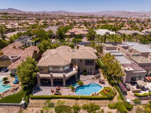
Benefits of Drone Photography for Real Estate
Drone photography significantly enhances real estate marketing by providing stunning visuals that attract potential buyers. Properties showcased with aerial images offer a comprehensive perspective of the property and its surroundings, which is particularly important in Las Vegas’s competitive market. For instance, a property listing featuring drone footage can highlight unique features such as expansive yards, pools, and proximity to local amenities, making it more appealing to prospective clients. Studies show that properties listed with drone footage receive 68% more inquiries than those without.
Professional drone pilots, such as those at Sky View LV, offer customized consultations tailored to each client’s specific needs. This personalized approach ensures that the captured images align with the marketing strategy, thereby improving the effectiveness of the real estate listing. High-resolution aerial photography can enhance marketing materials and online listings, providing a distinct competitive advantage.
Services Offered by Drone Pilots in Las Vegas
Drone pilots in Las Vegas provide a diverse range of services tailored to various industries. Standard offerings include aerial photography and videography for real estate, commercial projects, and events. Additionally, specialized services, such as mapping and surveying, are available, providing detailed data to support construction and planning projects. For example, accurate aerial maps can help developers understand land topography and plan layouts effectively.
Drone pilots also offer customizable wedding and event packages that capture unique moments from dramatic aerial angles. Real-time video streaming capabilities enable clients to monitor events and construction progress, enhancing transparency and engagement. The ability to adapt services to meet specific client needs is a hallmark of many drone photography businesses in Las Vegas.
Compliance and Safety in Drone Operations
Operating drones in Las Vegas requires adherence to strict FAA regulations, including holding a Part 107 license. Professional companies like Sky View LV ensure their pilots are FAA certified, which is crucial for legal and safe operations. Compliance with local authorities is also necessary to obtain aerial permits, especially when flying in busy urban areas such as Las Vegas.
Safety is a top priority for drone operators, necessitating pre-flight inspections and adherence to visual line-of-sight regulations during flights. Continuous education and training enable pilots to stay current with technological advancements and regulatory changes, ensuring they remain compliant and effective. Professional drone services prioritize these aspects to ensure safe, compliant operations, which are essential to maintaining industry standards and client trust.
Technology Used in Drone Photography
The technology used in drone photography has advanced significantly, enabling the capture of high-quality aerial footage. Drones such as the DJI Inspire 3 and DJI Mavic 3 Cine are widely used for their advanced camera capabilities and stabilization, enabling professional-grade imagery. Additionally, equipment such as the DEFY Cadence cable cam system enhances aerial shot quality, delivering smooth, cinematic video.
Professional drone services often include in-house editing teams that streamline the process, allowing for same-day project delivery in many cases. Specialized applications, including thermal and multispectral cameras, are also used for tasks such as agricultural monitoring and building inspections. These technological advancements ensure that aerial photography services in Las Vegas remain competitive and able to meet diverse client needs.
Choosing the Right Drone Photography Service
Selecting the appropriate drone photography service requires careful consideration of several factors. It is essential to verify FAA certification and insurance coverage, as both are crucial to legal compliance and safety. Companies like Sky View LV provide a range of drone photography and videography services tailored to specific industries, making it easier for clients to find the right fit for their project needs.
Reading customer testimonials can offer valuable insights into the quality of service and professionalism of a drone pilot. Inquiring about the pilot’s experience with similar projects can also help ensure that their specific requirements are met. It is advisable to verify the company’s safety record and regulatory compliance to provide peace of mind during operations. Discussing potential post-production services can clarify expectations for the final product.
The Future of Drone Photography in Las Vegas
The future of drone photography services in Las Vegas appears promising, with anticipated technological advancements expected to enhance the quality and accessibility of aerial imagery. The increasing use of drones for commercial applications, including inspections and mapping, is expected to continue growing. As regulatory frameworks evolve, they may allow for expanded operational capabilities in urban environments.
Furthermore, integrating AI and machine learning into drone photography could improve automated editing and data analysis. Community initiatives and workshops are emerging to educate aspiring drone pilots and promote responsible drone use. With tourism continuing to flourish, demand for unique aerial content that captures the essence of Las Vegas is likely to rise, solidifying the role of Drone Services in Nevada’s vibrant landscape.
In the bustling, ever-evolving city of Las Vegas, capturing its awe-inspiring landscape from a unique perspective is no easy task. However, Sky View LV, a leading drone photography company, is changing how we see the world. Whether you’re looking to capture the sweeping beauty of the Strip, showcase an architectural masterpiece, or create unforgettable memories from above, Sky View Las Vegas offers high-quality, professional drone photography services to meet all your needs.
A New Age of Photography
Drone photography has revolutionized imagery, offering a bird’s-eye view that traditional photography cannot match. Sky View LV understands the importance of capturing moments and landscapes in their entirety, providing clients with breathtaking aerial shots and videos that add a touch of magic to any project. From sweeping aerial views of the city to intimate close-ups of gatherings, Sky View LV captures every angle.
Why Choose a Drone Photography Company?
When it comes to capturing unique perspectives, a drone photography company like Sky View LV offers several distinct advantages:
Stunning Aerial Shots: Traditional photographers can only work within the constraints of ground-level views, but drones take your photography to new heights—literally. They can shoot from angles and elevations that would otherwise be impossible with a standard camera.
Time and Cost Efficiency: Using a drone significantly reduces time and costs associated with capturing high-quality aerial footage. Drones can cover large areas quickly, while providing the same, if not better, quality as traditional helicopter shoots, which are much more expensive.
Versatility: Whether you’re a business looking to showcase your property, a couple in need of a unique wedding album, or a filmmaker working on a project, drone photography offers unparalleled versatility in the shots it can capture.
Precision and Detail: Modern drones are equipped with high-definition cameras that capture images in incredible detail. This precision allows Sky View LV to create high-quality visuals that meet even the most stringent standards.
Services Offered by Sky View LV
Sky View LV offers a variety of services to cater to every need. Whether you’re an individual, a business, or a creative professional, there’s a service tailored to your needs.
Real Estate Photography
One of Sky View LV’s most sought-after services is drone photography for real estate. Given the competitive nature of the Las Vegas real estate market, sellers and agents must make their properties stand out. Aerial shots of a home or property can highlight its features in ways traditional photography cannot.
Sky View LV provides high-definition aerial photos and videos that capture the property’s scale, surrounding neighborhoods, and nearby landmarks. This not only gives potential buyers a clearer view of what’s for sale but also adds an eye-catching element to property listings, driving interest and increasing the chances of a successful sale.
Event Photography and Videography
Whether it’s a wedding, corporate event, or outdoor gathering, Sky View LV can provide clients with stunning aerial shots that capture the essence of any event. A bird’s-eye view of an outdoor wedding or concert can give a sense of grandeur and scale, allowing clients to relive their memories in a way that ground-level photos can’t match.
The beauty of using drones for events is that they capture moments from unique angles, offering a fresh take on your special day. Whether you need cinematic shots or simple documentation, Sky View LV has the tools and experience to deliver.
Construction and Architecture
For architects and construction companies, Sky View LV provides construction-site photographyto track project progress. Drones can capture aerial footage that shows construction progress, from the foundation to the final touches. This service helps clients monitor timelines, evaluate changes, and provide stakeholders with real-time visual updates.
For architectural firms, drone photography is invaluable for capturing the beauty and scale of their designs. Aerial views help highlight the structure’s integration into its environment, making them perfect for portfolios, presentations, and marketing materials.
Film and Cinematic Shots
Sky View LV specializes in aerial cinematography for filmmakers. Drones are a vital tool in capturing dynamic, high-quality aerial shots, which are essential for modern filmmaking. Whether you’re shooting a commercial, music video, or feature film, the team at Sky View LV ensures smooth, stable footage that elevates your storytelling.
Technology Behind the Magic
What sets Sky View LV apart from other drone photography companies is its commitment to using the latest drone technology. The company utilizes drones equipped with high-quality cameras to capture stunning, high-definition photos and videos. These state-of-the-art drones provide precise control, stability, and safety, which are essential when flying over complex environments such as the Las Vegas skyline or busy construction sites.
The drones used by Sky View LV are capable of shooting in 4K resolution, offering crisp, clear, and vivid imagery. These images can then be edited and tailored to each project’s specific needs, from color correction to special effects.
Advanced Software for Editing
Beyond the drone itself, Sky View LV also employs cutting-edge software for photo and video editing. Whether you need a quick touch-up or a detailed editing process, the team can produce images and videos that align with your vision. The ability to fine-tune your aerial photos ensures that you receive the best possible product, whether it’s a simple image for social media or a polished video for a commercial.
The Sky View LV Team
The team at Sky View LV comprises highly trained drone operators who are not only experts in operating drones but also skilled photographers and videographers. They work closely with clients to understand their vision, ensuring that every shoot is done with precision and care.
Sky View LV places a strong emphasis on safety. Their drone operators follow strict safety protocols to ensure every flight complies with FAA regulations, giving clients peace of mind that their projects are handled responsibly.
Client Testimonials: What People Are Saying
Sky View LV has built a strong reputation for delivering exceptional service. Here’s what a few clients have said:
“Sky View LV took our real estate listing to the next level. The aerial shots of our home were stunning and helped us close the sale in record time.” – Tina M., Real Estate Agent.
“We hired Sky View LV for our wedding, and we couldn’t be happier. The drone shots of our ceremony were breathtaking. We’ll cherish those photos forever.” – David and Michelle P., Newlyweds.
“As a filmmaker, getting the right shot is crucial. The team at Sky View LV delivered cinematic footage that elevated our project to new heights.” – Jake L., Filmmaker
Conclusion
Whether you’re a business looking to showcase your property, a couple looking to capture your special day, or a filmmaker searching for the perfect aerial shot, Sky View LV is the drone photography company that can take your project to new heights—literally. With cutting-edge technology, a skilled team, and a commitment to quality, Sky View LV delivers unparalleled drone photography services. So, the next time you’re looking for a fresh perspective, consider taking to the skies with Sky View LV.