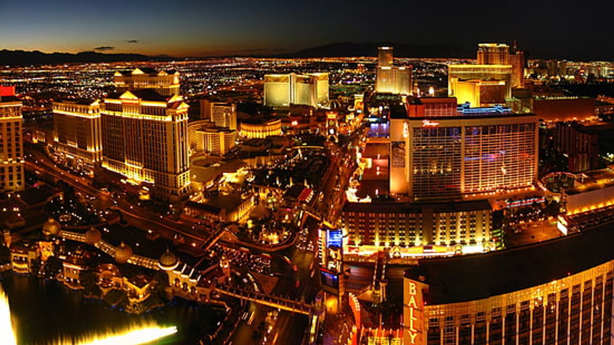
Aerial Photographer in Las Vegas. Las Vegas is renowned for its vibrant cityscape and iconic landmarks, making it a spectacular subject for aerial photography. From the glitz of the Strip to the architectural marvels dotting the skyline, aerial photographers in Las Vegas offer a unique perspective on this bustling metropolis. With advanced drone technology and skilled photographers, capturing the essence of Las Vegas from the skies has never been more accessible or impressive. Whether for real estate marketing, event coverage, or surveying land, aerial imagery in Las Vegas elevates visual storytelling to new heights.
Key Takeaways
Aerial photography in Las Vegas, powered by drone technology, provides exceptional views of the city’s famous landmarks and events.
Sky View Las Vegas stands out with FAA certification, ensuring compliance with PART 107 and Section 333 regulations for safe and legal aerial photography services.
Real estate and architectural photography from above offers a compelling advantage for property listings, enhancing marketing efforts with a bird’s-eye perspective.
Specialized niches such as helicopter wedding photography and corporate event coverage cater to unique demands, capturing unforgettable moments and professional engagements from the skies.
Capturing the Essence of Las Vegas: Aerial Photography Services
Skyward Marketing: Drone Excellence
As the founder of Sky View Las Vegas, I’ve dedicated myself to providing top-tier aerial photography services in Las Vegas. Our team is equipped with the latest drones and cutting-edge software, ensuring that every shot captures the vibrancy and excitement of this iconic city. We’re not just about taking pictures; we’re about telling stories from the sky.
Our services cater to a diverse range of clients, from real estate agents looking to showcase properties to event organizers wanting to add a unique perspective to their coverage. Here’s a glimpse of the industries we serve:
Real Estate (commercial and residential)
Vacation Rentals (Airbnb, VRBO)
Building Inspection
Industrial
Sporting Events
Trade Shows
With FAA Part 107 certification and full insurance coverage, we adhere to the highest standards of safety and compliance. Our commitment to excellence is reflected in every project we undertake.
Pricing is always a consideration, and we strive to offer competitive rates without compromising quality. Below is a table highlighting the average cost of aerial photography services:
Region
Great Value
Average
Premium
Nationwide
$125
$200
$350
East North Central
$100
$150
$300
Mountain
$125
$200
$300
Pacific
$135
$199
$350
South Atlantic
$150
$200
$350
I invite you to visit our website at https://skyviewlv.com/ to explore our portfolio and learn more about how we can elevate your visual presence. Let’s soar together and capture the essence of Las Vegas from an unparalleled perspective.
Event Photography: Corporate and Celebratory Occasions
In the bustling city of Las Vegas, event photography transcends mere documentation; it’s about capturing the vibrancy and unique atmosphere of each occasion. Corporate events and celebratory gatherings demand a keen eye for detail and a flair for encapsulating the essence of the event. From grand openings to gala dinners, my camera is an extension of the observer, capturing moments that become treasured memories by companies and families alike.
With every shutter click, I aim to tell a story, to weave a visual narrative that echoes the laughter, the speeches, the spontaneous interactions that define an event.
Here’s a glimpse into the variety of events I’ve had the pleasure of photographing:
Corporate conferences and seminars
Product launches and brand activations
Award ceremonies and recognition banquets
Family reunions and anniversary celebrations
Weddings and engagement parties
Each event is a new canvas with endless possibilities, set against the backdrop of Las Vegas. Your commitment to excellence ensures that every photograph is not just a picture but a moment in time, preserved with the utmost care and professionalism.
Real Estate and Architectural Wonders from Above
As an aerial photographer in Las Vegas, I’ve captured the city’s dynamic real estate and architectural marvels from a vantage point that few experience. The bird’s-eye view offers a comprehensive perspective, showcasing properties in their entirety and highlighting the unique designs that make Las Vegas structures stand out.
The addition of aerial images to traditional land survey drawings communicates a ‘thousand words,’ providing clarity and context that ground-level photography simply cannot match.
My services cater to a diverse range of clients, from commercial real estate moguls to individual residential property listings. Here’s a glimpse into the sectors I serve:
Real Estate (commercial and residential)
Vacation Rentals (Airbnb and VRBO)
Building Inspection
Industrial
Each project is approached professionally, ensuring that every angle and detail is captured precisely. FAA Part 107 certified and fully insured, adhering to the highest safety and compliance standards in the industry.
Elevating Real Estate Marketing with Aerial Imagery
Drone Aerial Photography for Property Listings
In the bustling real estate market of Las Vegas, drone aerial photographyhas become an indispensable tool for showcasing properties. With the city’s unique skyline and stunning desert landscapes, aerial imagery offers a distinct advantage, providing potential buyers with a comprehensive view that ground-level photos can’t match.
As a professional aerial photographer, I’ve seen firsthand how these elevated shots can enhance property listings. Hey, capture the scale and context of a property, highlighting its surroundings, which is often a key selling point. Here’s a quick rundown of the benefits:
Elevated Perspective: Gain a bird’s-eye view of the entire property.
Contextual Awareness: Show proximity to amenities and landscapes.
Impressive Marketing: Stand out in a competitive market with striking visuals.
The right angle from above can transform a standard listing into an eye-catching showcase, making it a must-have in your marketing arsenal.
Pricing is also a crucial aspect to consider. According to recent data, the average cost of aerial photography services in Las Vegas is approximately $200, with variations depending on the project’s scope and complexity. It’s an investment that pays dividends by enhancing the appeal of your listings and potentially accelerating the sale process.
Short-Term Rental Photography: A New Perspective
In the bustling city of Las Vegas, I’ve discovered that short-term rental photography offers a unique opportunity to showcase properties in a way that stands out in the crowded market. Capturing the allure of a rental space through the lens of a drone provides potential guests with a comprehensive view that traditional photography can’t match.
Aerial shots highlight the property’s layout and proximity to Las Vegas attractions.
Interior drone photography can create a dynamic tour of the space, offering a unique perspective.
Twilight aerial photography captures the property in the enchanting desert sunset.
Embracing this new perspective has not only elevated my portfolio but has also provided clients with an invaluable tool for marketing their rentals. The bird’s-eye view offered by drones gives a sense of scale and location that is essential in conveying the true value of the property.
Ensuring that each shot is meticulously planned and executed is crucial to producing high-quality imagery that entices viewers. From selecting the right time of day to understanding the unique angles that best represent each property, my approach is both artistic and strategic.
In my pursuit of capturing the architectural elegance of Las Vegas, I’ve come to appreciate the intricate dance between light and structure. My playground is the city’s skyline, a canvas of innovation and style. Ach building tells a story, and through my lens, I aim to narrate these tales of design and ingenuity.
With a keen eye for detail and a passion for the art form, I specialize in showcasing the architectural marvels of Las Vegas. From the sweeping curves of modern casinos to the geometric precision of corporate headquarters, my photographs serve as a testament to human creativity and ambition.
Here’s a glimpse into the variety of structures I’ve had the pleasure of photographing:
Iconic casino resorts with their lavish facades
Cutting-edge corporate buildings
Unique industrial designs
Residential complexes that redefine luxury
Ensuring each image captures the essence of the structure, I work meticulously to highlight the beauty that might otherwise go unnoticed. It’s not just about taking a picture; it’s about immortalizing architectural art.
Specialized Aerial Photography Niches in Las Vegas
Helicopter Wedding Photography: Capturing Your Special Day
As I hover above the Las Vegas Strip, camera in hand, I’m not just a photographer—a storyteller capturing the essence of your helicopter wedding. The city’s lights twinkle like stars, creating a breathtaking backdrop for your special day. The moments we seize from the sky will be timeless treasures, a testament to your love and the grandeur of your celebration.
The intimacy of your vows, the laughter of your guests, and the grandiosity of the landscape below are all immortalized from this unique vantage point. It’s not just about the photos; it’s about the experience and the memories we create together.
Here’s what you can expect when you entrust your memories to me:
Warm Welcome and Personalized Attention: Your experience begins when you step onto the helipad.
Unforgettable Panoramic Views: The Las Vegas Valley unfolds beneath you, offering a canvas like no other.
Luxurious Comfort: Rest assured, your journey will be as comfortable as it is breathtaking.
I understand the importance of flexibility and personal touch. That’s why I offer complimentary date changes and encourage personalized vows to make your ceremony truly yours. With over 25 years of experience, I quickly navigate the complexities of aerial photography, ensuring that every emotion and detail of your helicopter wedding is captured flawlessly.
Corporate Event Coverage: From Trade Shows to Award Banquets
As an aerial photographer in Las Vegas, I’ve had the privilege of capturing the grandeur of corporate events from a unique vantage point. The energy and scale of trade shows and award banquets are magnified from above, offering a perspective that ground-level photography cannot match.
In the bustling atmosphere of Las Vegas, aerial photography adds a layer of sophistication and excitement to corporate event coverage. It’s not just about taking pictures; it’s about telling a story from the sky.
Here’s a glimpse into the process:
Pre-event consultation to understand the client’s vision
Strategic planning of flight paths to cover key event highlights
Real-time monitoring and adjustment to capture dynamic moments
Post-event editing to deliver stunning, high-quality images
Whether it’s the vast expanse of a convention center or the intricate details of a banquet setup, my goal is to provide clients with a comprehensive visual narrative of their event. It is a powerful promotional tool and a cherished memento of their Las Vegas experience.
Advertising and Editorial Imagery: The Sky’s the Limit
In the bustling city of Las Vegas, advertising and editorial imagery take on a new dimension when viewed from above. The aerial perspective offers a unique vantage point that can transform the ordinary into the extraordinary, capturing the essence of a brand or story with dramatic flair. As an aerial photographer, I’ve seen firsthand how high-quality drone photography can elevate a marketing campaign or editorial piece.
With the city’s iconic skyline and vibrant landscapes, aerial shots provide a compelling backdrop for any visual narrative.
Here’s a quick rundown of the types of projects I’ve been involved with:
Commercial product launches that require a grand scale
Editorial features that tell a story with a bird’s eye view
Dynamic advertising campaigns that stand out in a crowded market
Choosing the right aerial photographer in Las Vegas is crucial for achieving the desired impact. It’s not just about having the right equipment; it’s about understanding the vision behind the project and bringing it to life. Our imagery should be spectacular in Las Vegas, where the sky’s the limit.
Ensuring Quality and Compliance in Aerial Photography
FAA Certification and Insurance: A Must for Aerial Photographers
In my line of work, FAA certification and proper insurance are non-negotiable.It’s not just about compliance; it’s about professionalism and trust. Clients need to know that their aerial photographer operates within the bounds of the law and is covered in the event of an accident.
Here’s a quick rundown of what I ensure before every flight:
FAA Part 107 remote pilot license
Registered drones with the FAA
Proof of insurance available upon request
Ensuring these elements are in place provides peace of mind for both the photographer and the client, setting the stage for a successful project.
Regarding pricing, it’s important to note that costs can vary based on the region and the level of service required. Here’s a snapshot of average pricing across different areas:
Region
Great Value
Average
Premium
Nationwide
$125
$200
$350
East North Central
$100
$150
$300
Mountain
$125
$200
$300
Pacific
$135
$199
$350
South Atlantic
$150
$200
$350
Remember, choosing the right aerial photographer is about more than just price—it’s about finding someone who can deliver the quality and perspective that your project deserves.
Adhering to PART 107 and Section 333 Regulations
As an aerial photographer, I take pride in capturing stunning visuals from the skies above Las Vegas, while strictly adhering to the regulations that govern our airspace. Compliance with FAA PART 107 and Section 333 is not just a legal obligation; it’s a commitment to safety and professionalism in the industry.
Ensuring that every flight is conducted within the bounds of these regulations is a cornerstone of my service. It’s about respecting the airspace we share and the trust my clients place in me.
Here’s a quick rundown of what these regulations mean for my operations:
FAA Part 107 is the primary set of rules governing the commercial operation of small unmanned aerial systems (UAS). It covers pilot certification, airspace restrictions, and operational limitations.
Section 333 grants an exemption for certain UAS operations that can be conducted safely in the national airspace. It’s an additional layer of certification that allows for more specialized drone operations.
I maintain a transparent relationship with my clients, providing proof of insurance and necessary certifications upon request My clientele spans diverse industries, each with unique needs and regulatory considerations Whether it’s real estate, event coverage, or industrial inspections, my services are tailored to meet these specific requirements while upholding the highest standards of aerial photography.
Choosing an Insured and Experienced Aerial Photographer
When selecting an aerial photographer, ensuring they are insured and experienced is paramount. This not only protects you from liability but also provides a level of professionalism and quality in the captured aerial imagery.
As an aerial photographer, I’ve learned that the assurance of insurance and a proven track record can make all the difference to clients. They can rest easy knowing that their project is in safe hands.
Here’s a quick checklist to consider when choosing your aerial photographer:
Verify their FAA certification and insurance coverage.
Review their portfolio to assess their experience and style.
Check for client testimonials and ratings.
Discuss their familiarity with the specific type of aerial photography you need.
Remember, the right aerial photographer will have the technical skills and creative eye to showcase your project from the best angles above.
At Sky View Las Vegas, we take pride in delivering exceptional aerial photography that meets the highest quality and compliance standards Our FAA-certified drone pilots are fully insured and authorized to capture stunning, high-resolution images that can transform your real estate listings, construction projects, and commercial property showcases Don’t let your property get lost in the crowd; elevate your marketing with our cutting-edge aerial photography services Visit our website to explore our gallery and schedule your free consultation today!
Conclusion
In the vibrant city of Las Vegas, aerial photography has taken on a life of its own, offering breathtaking perspectives of both natural and artificial wonders From the glittering Strip to the architectural marvels, skilled photographers and cutting-edge drone technology come together to capture the essence of Sin City Companies like Sky View Las Vegas, which holds FAA certification and offers insured services, stand at the forefront of this industry, providing top-notch drone media solutions Whether for real estate, event photography, or even a helicopter wedding, Las Vegas’ aerial photographers are equipped to deliver high-quality, memorable images As the demand for unique and compelling visuals continues to grow, the aerial photographers of Las Vegas are ready to rise to the occasion, ensuring every shot is as extraordinary as the city itself.
Las Vegas aerial photographers offer a range of services, including drone aerial video and photography, real estate photography, short-term rental photography, architectural photography, interior photography, and event photography for corporate events, trade shows, award banquets, parties, and conventions.
Are aerial photographers in Las Vegas certified and insured?
Yes, reputable aerial photographers in Las Vegas, such as Sky View Las Vegas, hold FAA certification and are fully licensed and insured, adhering to PART 107 and Section 333 regulations.
Can I hire an aerial photographer for a helicopter wedding in Las Vegas?
Helicopter wedding photography is a specialized niche in Las Vegas, capturing the magic and emotions of your special day with high-quality aerial photographs.
What should I look for when choosing an aerial photographer in Las Vegas?
When selecting an aerial photographer, ensure they are FAA-certified, insured, and have relevant experience in the field. Check their portfolio for quality and compliance with aviation regulations. Look for photographers specializing in the type of imagery you need, such as event coverage or real estate marketing.
How can aerial photography enhance real estate marketing?
Aerial photography provides a unique perspective, showcasing properties in their entirety and highlighting the surrounding landscape. It’s especially effective for property listings, architectural beauty, and short-term rentals, giving a competitive edge in real estate marketing.
The Impact of Aerial Photography on Luxury Home Sales. In the real estate industry, the evolution of aerial photography has become a transformative force. It’s no exaggeration that it actively reshapes how properties are showcased and perceived. This is particularly notable in the synergy between aerial photography and luxury home sales, which aptly illustrates the value of aerial photography. From its humble beginnings, where static images dominated listings, to the current era of dynamic visual storytelling, aerial photography has emerged as a critical player. This technique goes beyond merely capturing exteriors; it crafts a narrative, immersing potential buyers in a grand visual experience. Let us explore aerial photography in real estate, unraveling its pivotal role in enhancing the allure and impact of luxury homes.
Aerial Photography and Luxury Home Sales
First, let us explore the impact of aerial photography on sales themselves. By outlining how it does so, we can provide a more thorough understanding of how its influence extends to relocations and real estate marketing.
Aerial photography has emerged as an invaluable asset in showcasing luxury homes.
Capturing the Essence: Enhancing Property Presentation
Aerial photography transforms property presentation by offering a grand-scale view of exteriors. Unlike conventional methods, this technique captures homes in their entirety, providing a comprehensive perspective that showcases the property’s true essence. From the soaring rooflines to the sprawling landscapes, potential buyers can appreciate the entirety of a luxury home’s offerings.
Additionally, aerial photography excels in highlighting surrounding landscapes and amenities. It extends beyond the property boundaries, revealing lush greenery, expansive yards, and proximity to key features such as parks or waterfronts. This paints a vivid picture of the property’s context, allowing buyers to envision their lifestyle within the broader, luxurious setting.
Creating Emotional Connections
Additionally, aerial photography plays a pivotal role in forging emotional connections. It does so by tapping into the aspirations of potential buyers through breathtaking views and stunning visuals. The expansive and awe-inspiring perspectives captured by aerial shots evoke a sense of grandeur, allowing individuals to envision themselves in these luxurious spaces. This visual storytelling transcends the mundane and creates a powerful emotional impact, making the property a dream-worthy lifestyle project.
In addition, the technique enhances the perceived value of luxury properties. Aerial photography conveys exclusivity and prestige by showcasing homes from elevated angles, highlighting architectural intricacies and their harmonious relationship with the surrounding environment. This, in turn, fosters a deeper connection with prospective buyers who can see the property’s intrinsic value.
Informing Purchasing Decisions
Indeed, aerial photography has proven instrumental in informing purchasing decisions. Statistics underscore this synergy between aerial photography and luxury home sales.
Listings featuring aerial visuals experience a significant increase in engagement, with higher click-through rates compared to listings without such imagery. Prospective buyers, drawn to the immersive and detailed views of aerial shots, spend more time exploring these listings. Furthermore, properties with aerial photography tend to sell faster, with a decrease in time on the market. This highlights the tangible influence of aerial photography in shaping buyer perceptions and expediting decision-making processes.
Aerial photography offers newfound convenience for potential buyers, directly affecting the sales process.
The Impact of Aerial Photography on Relocation
In turn, aerial photography has a tangible influence on relocation trends. It does so on similar grounds, which also deserve due exploration.
Virtual Exploration
Aerial photography significantly influences the relocation process by offering a revolutionary form of virtual exploration. It provides a comprehensive view of the property beyond the traditional confines of static images. As such, it allows potential buyers to immerse themselves in the entire landscape. This immersive experience becomes crucial in aiding remote decision-making for those contemplating a move. Prospective buyers can virtually navigate through luxury homes, scrutinize the surrounding areas, and make informed decisions from the comfort of their current location.
That said, it’s crucial not to let the emotional satisfaction of virtual exploration distract you from the relocation process. Whether the move is just down the street or across state lines, transitioning from virtual exploration to physical relocation demands a strategic approach. In this endeavor, aligning with a dependable moving company becomes pivotal for a smooth transition. In Northern Virginia, where relocators are increasingly embracing virtual tours and luxury home sales are experiencing a surge, Zippy Shell movers stand ready to offer their expertise. A distinguished name in the moving industry and a trusted partner for those relocating with valuable belongings, Zippy Shell Northern Virginia is well-equipped to facilitate your move. With the aid of virtual exploration and a reliable moving partner, the prospect of relocation becomes an exciting, well-managed adventure.
Understanding the Neighborhood
Beyond virtual explorations of the property, aerial photography offers a comprehensive understanding of the neighborhood. Through aerial shots, prospective buyers can precisely gauge the property’s proximity to key locations. This visual tool surpasses traditional maps, enabling individuals to assess local infrastructure and features from a bird’s-eye view.
Whether it’s the distance to schools, parks, or commercial areas, aerial photography provides an invaluable perspective on the neighborhood layout. It thoroughly examines the surroundings to capture aerial perspectives of beauty and informational value. As such, it helps potential residents make informed decisions about the suitability of a location for their lifestyle.
With the advent of drone photography in marketing, the synergy between aerial photography and luxury home sales has reached new heights.
Informing Relocation Trends
With the above in mind, aerial photography actively shapes relocation trends, as evidenced by compelling statistics. Recent data reveals that listings incorporating aerial visuals witness a notable increase in engagement from prospective relocating buyers. The ability to virtually explore neighborhoods and assess properties from an elevated perspective has proven to be a decisive factor in the decision-making process.
So, this reliably underscores the impact of aerial photography on informing relocation trends. They suggest a growing reliance on visual tools for making informed decisions about prospective homes and neighborhoods. The dynamic shift towards leveraging aerial imagery redefines how individuals approach and navigate the relocation landscape.
Summarizing Aerial Photography’s Role in Luxury Home Sales
In conclusion, the symbiotic relationship between aerial photography and luxury home sales is virtually undeniable. With its ability to showcase properties on a grand scale and create emotional connections, aerial photography has become a linchpin in the real estate market. Its impact on relocation, helping buyers virtually explore and understand neighborhoods, reshapes how individuals approach the decision to move. As we navigate the real estate market, aerial photography is essential for successful marketing. It has become the cornerstone in portraying luxury homes in their most accurate light, influencing buyer decisions, and ultimately transforming the landscape of luxury home sales.
Ultimate Drone Guide to FAA Authorizations/Waivers. Drones have become an increasingly popular tool for various industries, but navigating the regulations and authorizations set by the FAA can be complex. This article provides an in-depth guide to FAA authorizations and waivers for drone operations. From Part 107 waivers to UAS facility maps and advanced operations, we will cover everything you need to know to operate drones within the legal framework. Let’s dive in!
Key Takeaways
Understanding the process of obtaining a Part 107 waiver is essential for advanced drone operations.
UAS facility maps are valuable for identifying airspace restrictions and planning drone flights.
Public safety and government entities have specific regulations and requirements for drone operations.
Educational users can benefit from the UAS Collegiate Training Initiative and other educational resources provided by the FAA.
Advanced operations, such as package delivery and emergencies, require thorough certification and compliance with FAA regulations.
FAA Authorizations and Waivers
Overview of Part 107 Waiver
After obtaining my Part 107 waiver, I’ve learned that it’s crucial to understand the responsibilities it entails. The Responsible Person is the linchpin of safe drone operations under the waiver. They must ensure that the remote Pilot in Command (PIC), manipulators of the controls, and Visual Observers (VOs) are informed about the waiver’s terms and strictly adhere to them. This includes being well-versed in Part 107 regulations.
Before any drone flight, the Responsible Person must file a Notice to Airmen (NOTAM) within a specific timeframe. Here’s a quick rundown of the steps:
Inform and ensure the team understands waiver terms.
Document evidence of compliance.
File a NOTAM between 24 and 72 hours before the operation.
It’s imperative to document all compliance efforts and be ready to present them if requested by the FAA or an authorized representative. This proactive approach not only ensures legality but also enhances safety.
As someone who’s gone through the process, I can attest to the importance of these protocols. They are not just bureaucratic hurdles but measures that protect the operator and the public. For instance, aerial photography in Las Vegas requires diligence to capture the city’s grandeur without compromising safety or legality.
UAS Facility Maps
Navigating the skies with a drone in urban environments can be tricky, especially when understanding the various flight modes. Operating drones in urban areas requires understanding flight modes.ATTI mode is beneficial in cities, as it allows for manual control and helps prevent crashes when GPS signals are unreliable or interrupted.
UAS Facility Maps are a critical tool for drone pilots, providing essential information on airspace restrictions and requirements. These maps indicate areas where drone flight is controlled, and FAA authorizations are necessary. For instance, areas near airports are often marked with specific altitude limits. Here’s a simple breakdown of what you might find on a UAS Facility Map:
Maximum altitude allowed for drone flight
Boundaries of controlled airspace
Locations requiring special FAA authorization
Understanding these maps is crucial for hobbyists and commercial operators to ensure safe and legal drone operations.
It’s important to remember that while UAS Facility Maps provide valuable guidance, they are not the sole resource for airspace information. Always cross-reference with other tools and resources to maintain situational awareness and comply with all regulations.
Public Safety and Government
As a drone enthusiast and researcher, I’ve come to understand the critical importance of drones in public safety and government operations. Drones are transforming how emergency services and government agencies respond to incidents, offering rapid aerial surveillance and situational awareness that can be crucial in life-threatening situations.
For instance, drones are used extensively for search and rescue missions, where time is of the essence. They provide a bird’s-eye view that can help locate missing persons or survey disaster areas without risking further loss of life. Additionally, drones play a significant role in law enforcement, aiding crowd monitoring and crime scene analysis.
It’s essential to recognize the balance between the benefits of drone technology and the need to respect privacy laws. Drones and privacy laws are a growing concern. Commercial and personal drone use raises privacy issues, and regulations are evolving to address these challenges.
The FAA has established specific guidelines for public safety and government drone operations, which include:
The ability to operate in restricted airspace with proper authorization
Special provisions for emergencies
Requirements for certification and training
Understanding these regulations is crucial for any entity that leverages drones for public service. The FAA’s commitment to integrating drones safely into the national airspace system while respecting privacy concerns is evident in its ongoing policy development and enforcement efforts.
Educational Users
As an avid drone enthusiast and educator, I’ve found that the FAA provides specific pathways for educational users to integrate drones into their curriculum. Academic institutions can apply for authorizations and waivers that allow them to conduct operations that would otherwise require a Part 107 certificate.
Educational users encompass a wide range of entities, from primary schools to universities. These institutions often engage in research, hands-on training, and community outreach activities. To support these efforts, the FAA has established the UAS Collegiate Training Initiative, which outlines the requirements and resources available to educational users.
The key to successfully integrating drones into educational programs is understanding the regulatory framework and leveraging the available resources to ensure compliance and safety.
Here’s a quick overview of the process for educational users seeking FAA authorizations:
Determine the type of operation and if it falls under the scope of educational use.
Review the UAS Facility Maps to identify any airspace restrictions.
Submit a Certificate of Waiver or Authorization (COA) application through the FAADroneZone portal.
Await approval from the FAA, which may require additional documentation or clarification.
Remember, while the process may seem daunting, the FAA is committed to supporting educational initiatives that promote the safe integration of drones into the national airspace.
Advanced Operations
When we engage in advanced drone operations, precision and expertise are paramount. Safety is the cornerstone of these operations, often involving complex maneuvers or challenging environments. To ensure safety and compliance, I always follow drone safety tips, such as communicating with people and respecting private property.
Advanced operations may require special authorizations or waivers from the FAA, especially when they involve:
Flights in controlled airspace
Operations near airports
Night flights
Flights over people
Understanding the specific requirements and processes for obtaining these authorizations is crucial. For instance, the LAANC (UAS Data Exchange) provides a streamlined application process for airspace authorizations. At the same time, the UAS BEYOND program explores the expansion of drone operations beyond the visual line of sight (BVLOS).
In the context of advanced drone operations, continuous learning and staying updated with the latest FAA regulations and technological advancements is not just recommended, it’s essential.
Advanced drone operations are paving the way for innovative applications for commercial, environmental, or public safety purposes. They’re transforming industries and enhancing capabilities in ways that were once unimaginable.
Conclusion
In conclusion, the Ultimate Drone Guide to FAA Authorizations and Waivers provides a comprehensive overview of the regulations, processes, and considerations for drone pilots seeking FAA authorizations and waivers. From Part 107 waivers to UAS facility maps and airspace authorizations, this guide covers a range of essential topics for drone operators. This guide offers valuable insights and resources for public safety, government, or advanced drone operations. With a focus on legal compliance, safety, and best practices, drone pilots can confidently navigate the complex landscape of FAA authorizations and waivers. This guide is invaluable for novice and experienced drone pilots, equipping them with the knowledge and tools to operate drones responsibly and legally within the FAA’s regulatory framework.
Frequently Asked Questions
What is a Part 107 Waiver?
Part 107 Waiver allows drone operators to deviate from certain operational rules under Part 107 for specific purposes.
How can I obtain UAS Facility Maps?
UAS Facility Maps can be obtained through the FAA’s UAS Data Exchange website or other authorized sources.
What are the requirements for Public Safety and Government drone operations?
Public Safety and Government drone operations must adhere to specific regulations and may require additional authorizations or waivers.
How can Educational Users utilize drones?
Educational Users can utilize drones for educational and research purposes, provided they follow the applicable regulations and guidelines.
What are considered Advanced Operations for drones?
Advanced drone Operations include package delivery, emergency response, and other complex operations requiring special authorizations or waivers.
How do I apply for Part 107 Airspace Authorizations?
Part 107 Airspace Authorizations can be applied through the FAA’s online portal. The process involves specifying the desired airspace and operational details.
Innovating Architecture: The Rise of Construction Drone Services. The Las Vegas construction industry continually evolves, with drone services at the forefront of this transformation. Drones, equipped with cutting-edge cameras and sensors, have become pivotal in enhancing efficiency, safety, and project management on construction sites. St. Louis Drone Services exemplifies this innovation, offering comprehensive video and analytical capabilities that have redefined traditional construction practices. This article explores the multifaceted impact of drones, from enhancing site monitoring to integrating with advanced technologies like AR, and how these aerial sentinels are propelling construction to unprecedented heights.
Key Takeaways
Drones have revolutionized construction site monitoring, providing real-time, 3D visual data that enhances precision and safety in project management.
Integrating drones leads to significant cost savings and time efficiencies while also necessitating the development of new skill sets in the job market.
Compliance with regulatory frameworks, certification, and training for drone operators, as well as addressing privacy concerns, are critical challenges in adopting drone services.
Case studies demonstrate the successful application of drones in large-scale projects, disaster recovery, and historical restoration, showcasing their versatility.
Future trends predict further advancements in drone technology, with AI and machine learning playing a pivotal role in shaping the next frontier for construction drones.
Revolutionizing the Skies: Drones in Modern Construction
The Advent of Aerial Technology in Building
As I reflect on the transformation of the construction landscape, the introduction of dronesstands out as a pivotal moment. These aerial sentinels have revolutionized how we approach building projects, offering a level of precision and safety previously unattainable.
Aerial Surveying
Drones have made aerial surveying a breeze, providing high-definition images and videos that grant a bird’s-eye view of construction sites. This not only enhances the monitoring of progress but also aids in the early detection of potential issues.
Safety and Efficiency
Using drones has mitigated the need for manual inspections, which often involve risky climbs and time-consuming efforts. Now, with the push of a button, we can conduct thorough inspections and safety checks from the safety of the ground.
Tip: Regular drone surveys can significantly reduce the risk of project delays by identifying problems before they escalate.
Real-time Insights
The ability to capture real-time, 3D views of construction sites has been a game-changer. It ensures that materials are used efficiently, safety regulations are adhered to, and the project stays on track overall.
Integrating drones into construction is not just about adopting new technology; it’s about embracing a tool that enhances our capabilities and reshapes our expectations of what is possible in building.
Enhancing Precision and Safety on the Jobsite
As I’ve integrated drones into my construction projects, I’ve witnessed a remarkable improvement in precision and safety. These flying sentinels provide a bird’s-eye view that ground-based supervision can’t match. With their high-definition cameras and other specialized sensors, drones are the ultimate tool for hazard identification, detecting issues such as wobbly scaffolding or workers without proper safety gear.
The benefits extend beyond mere observation. Drones also contribute to creating detailed 3D models of the site, which serve as virtual maps to guide construction. This helps keep the project on schedule and ensures compliance with all safety and legal requirements.
Tip: Always ensure that your drone operations comply with local safety regulations to maintain a secure jobsite.
Here’s how drones have revolutionized safety on my sites:
Early detection of safety hazards minimizes potential incidents.
Enhanced site security reduces theft and vandalism.
Real-time data facilitates nimble decision-making, allowing for immediate corrective actions.
The impact is clear: drones have become an indispensable part of modern construction, ensuring that projects are completed with greater accuracy and with the utmost regard for safety.
Streamlining Surveying and Inspection Processes
In my experience, integrating drones into surveying and inspection processes has been a transformative experience. With the ability to quickly capture high-resolution data from above, I’ve seen firsthand how drones expedite the creation of detailed site maps and models. This capability fosters better collaboration and informed decision-making among all project stakeholders.
Efficient project management is crucial, and drones play a pivotal role in achieving this. By providing rapid, accurate site assessments, the need for frequent site visits is significantly reduced, enabling efficient remote monitoring. This saves time and enhances safety by minimizing the need for physical presence in potentially hazardous areas.
Here’s a snapshot of the benefits I’ve observed:
Enhanced precision in data collection
Improved safety and risk reduction
Significant time savings and cost reduction
Better resource allocation and project management
Remember, while drones offer remarkable advantages, it’s essential to maintain a balance between technological reliance and human expertise to ensure the highest standards of quality and safety.
Economic Impacts of Drone Integration
Cost-Effectiveness and Time Savings
In my experience, the cost-effectiveness of drones in construction is undeniable. The initial investment may appear steep, but the long-term labor and operational efficiency savings are substantial. For example, drones can survey large areas in a fraction of the time it would take human workers, leading to significant time efficiency gains.
Safety enhancements by reducing the need for manual inspections
Accurate data collection for informed decision-making
Real-time monitoring for timely issue resolution
This time efficiency translates to cost savings, as fewer person-hours are needed for monitoring and inspections. Moreover, the safety aspect cannot be overstated. By minimizing the need for workers to physically inspect dangerous areas, drones contribute to a safer working environment.
Remember, the value of drones goes beyond just financial metrics. They enable a level of precision and safety that was previously unattainable, making them an indispensable tool in modern construction.
Job Market Evolution and New Skill Sets
As I reflect on the trajectory of the construction industry, it’s clear that the job market is undergoing a profound transformation. The labor shortage is a persistent challenge, with a significant gap between the retiring workforce and the incoming talent. In 2024, I foresee a continued tight labor market, especially for onsite craft workers, and this trend doesn’t seem to be easing up.
To address this, firms prioritize recruiting young, entry-level employees. Integrating construction drones creates new roles and necessitates a shift in skill sets. Workers need to be proficient in technology, with a focus on data management and analysis. The rise of cost management software and collaborative KPI dashboards is a testament to the industry’s move towards more efficient project management.
Gen Z’s entrance into the workforce is poised to reshape our industry further. With their digital nativity, they’re accelerating the digital transformation of the construction industry. This shift involves adopting new technologies and embracing flexible work arrangements and hybrid schedules that align with the modern workforce’s preferences.
Embracing digital transformation is not optional; it’s imperative for attracting and retaining the next generation of construction professionals.
Here’s a glimpse at the evolving job roles in construction:
Drone Pilots and Data Analysts
Virtual Reality (VR) and Augmented Reality (AR) Specialists
Sustainability and Compliance Coordinators
Digital Project Managers
The adoption of VR and AR for training, the tracking of CO2 emissions, and the prioritization of socio-economic factors in projects indicate the broader changes underway. As we look towards the future, it’s clear that those who invest in these new skill sets will lead the industry’s evolution.
Long-Term Financial Implications for the Construction Industry
As I delve into the long-term financial implications for the construction industry, it becomes clear that the integration of drones is not just a fleeting trend but a strategic investment that will shape the future of construction economics. As highlighted in the snippets, the cost-effectiveness and efficiency of using drones are crucial in mapping, inspecting, and surveying, resulting in significant savings over time.
Embracing drone technology has proven to be a wise financial decision for forward-thinking firms. By reducing the need for manual labor in specific tasks, companies can mitigate the impact of workforce shortages and the associated costs. Here’s a glimpse into how drones contribute to financial sustainability:
Reduction in surveying time and costs
Decreased risk of workplace accidents
Lower insurance premiums due to enhanced safety measures
Improved project management through real-time data
Remember, the true value of drones goes beyond immediate cost savings. It lies in their ability to enhance the quality and longevity of construction projects, leading to a stronger industry reputation and the potential for increased profit margins.
In 2024, drone technology is expected to complement the industry’s shift towards an asset-first approach. This shift is expected to promote more sustainable and efficient construction practices, resulting in assets that are optimized for both performance and longevity. The focus on sustainability, as mentioned, is not only about being green but also about making financial sense in terms of cost, labor, and materials. Data-driven insights will be crucial in unlocking these long-term benefits and steering the industry toward a more profitable and sustainable future.
Regulatory Landscape and Compliance Challenges
Navigating Through Legal Frameworks
As I delve into construction drone services, I understand the critical importance of navigating legal frameworks. Integrating drones into commercial construction is governed by numerous regulations that ensure safe and compliant operations.
One of the primary certifications I’ve encountered is the Federal Aviation Administration’s Part 107, a cornerstone for commercial drone pilots. Adhering to these regulations is not just a legal obligation but also a mark of professionalism and commitment to safety.
Here are some key points to consider when navigating the legal landscape:
Understanding the scope of Part 107 and its applicability to your drone operations.
I am staying informed about local and state laws that may impose additional restrictions.
You ensure your drone activities do not infringe on privacy rights or airspace regulations.
Tip: Always stay informed about the latest regulatory changes and seek legal advice when in doubt to avoid costly penalties and project delays.
Certification and Training for Drone Operators
As I delve into the world of construction drones, I’ve come to appreciate the critical importance of proper certification and training for drone operators. It’s not just about knowing how to fly; it’s about understanding the intricate regulations that govern our skies.
To ensure compliance and safety, a structured approach to training is essential. Here’s a snapshot of the typical training process:
Familiarization with drone technology and basic flight proficiency
In-depth study of FAA rules and regulations
Hands-on flight practice under supervised conditions
Passing a knowledge test to obtain FAA certification
Remember, the goal of training is not only to pass the certification exam but also to cultivate a mindset of safety and responsibility.
Professional services, such as those offered by Drone Media St. Louis, emphasize the importance of FAA-certified pilots who are thoroughly trained in all aspects of drone operation and adhere to strict safety protocols. This level of expertise is crucial, mainly when drones are used for tasks such as aerial photography and cinematography in sectors like tourism and advertising.
Privacy and Airspace Concerns
As I delve deeper into the integration of drones within the construction industry, I am compelled to acknowledge the growing concerns surrounding privacy and airspace usage. The very nature of drones, capable of reaching areas otherwise inaccessible, raises questions about the surveillance of private property and the potential infringement on personal privacy.
To mitigate these concerns, I’ve compiled a list of best practices that drone operators should consider:
Ensuring compliance with local and national privacy laws
Establishing clear operational guidelines that respect privacy boundaries
Engaging with communities to foster transparency and trust
Moreover, navigating the crowded skies requires a keen understanding of the regulatory environment. It’s essential to avoid interference with commercial air traffic and to respect the frequency space of first responders and other critical services. Avoid flying in bad weather to ensure safety and compliance with FAA regulations.
Always consult with legal experts and regulatory bodies before conducting drone operations to ensure that all privacy and airspace regulations are strictly followed.
Case Studies: Successful Drone Applications
Large-Scale Construction Projects
I’ve been closely following the integration of drones in large-scale construction projects, and the results are nothing short of revolutionary. Drones have played a pivotal role in streamlining processes and enhancing accuracy on projects, such as Juneau Construction’s digital transformation. As Jim Pritchett of JTM Construction emphasizes, efficiency in data processing is now easily achieved, enabling the transformation of basic sketches into detailed 3D and 4D simulations.
The impact on project timelines is evident. For instance, the cmBuilder and Balfour Beatty US partnership highlights the breakthroughs in managing site logistics. Here’s a glance at the transformative effects:
Reduction in preconstruction planning time
Enhanced precision in site surveys
Improved safety protocols
Real-time monitoring and adjustments
Embrace the digital shift with open arms. The ability to visualize and adjust project plans in real-time is a game-changer for the construction industry.
Looking ahead, the role of drones is set to expand, influencing not only engineers and project managers but also the entire project team. With advancements in AI and a focus on optimizing workflows, I’m excited about the potential for industry-wide productivity and sustainability. As we move into 2024 and beyond, the trend of using drones in renovation projects is also on the rise, with over half of all future construction projects expected to involve significant refurbishments.
Disaster Recovery and Reconstruction Efforts
In the wake of natural disasters, the rapid deployment of drones has proven to be a game-changer in recovery and reconstruction efforts. These uncrewed aerial vehicles (UAVs) provide a unique vantage point, enabling a quick assessment of damage and identifying areas in dire need of assistance. I’ve witnessed firsthand how drones facilitate a more coordinated response, significantly reducing the time between disaster and recovery.
Drones also play a crucial role in ensuring the safety of workers during the reconstruction phase. They provide real-time surveillance, which helps to avoid potential hazards in structurally compromised environments. Moreover, delivering supplies to inaccessible areas is invaluable in these critical situations.
Remember: In disaster scenarios, time is of the essence. Drones can be the difference between a swift recovery and prolonged hardship.
Integrating drones into disaster management is not just about immediate response but also about building resilience. Analyzing the collected data can inform future infrastructure development and inform the creation of more effective disaster preparedness plans. It’s a testament to the power of technology in enhancing our ability to withstand and recover from catastrophic events.
Historical Preservation and Restoration
In my recent endeavors, I’ve become deeply involved in the delicate art of historical preservation and restoration. The goal is to balance minor interventions with the existing structure’s integrity, aiming for conservation over demolition. This approach honors the past and ensures these structures can continue to serve future generations.
Enhancing Existing Structures Through Retrofitting is a trend that’s particularly close to my heart. In cities like London, the focus is on maintaining the historic fabric of buildings while updating them for modern use. This requires a comprehensive data footprint involving multiple laser scans and engineering models.
Remember, the key to successful restoration is minimal interference with maximum respect for the original architecture.
Here’s a snapshot of the process:
Initial assessment of the building’s condition
Detailed laser scanning and 3D modeling
Structural analysis and planning for interventions
Careful execution of restoration work
By integrating drones into this process, we can achieve a level of precision and safety previously unattainable. Drones offer a bird’s-eye view, providing invaluable insights for inspecting hard-to-reach areas and creating detailed surveys that inform our restoration strategies. As we move forward, I’m convinced that drones will become an indispensable tool in our mission to preserve history.
Innovative Technologies and Future Trends
Advancements in Drone Hardware and Software
As I delve into the realm of construction drones, I’m continually amazed by the rapid advancements in drone hardware and software. These innovations are not just incremental improvements; they are reshaping the capabilities of drones in the construction industry.
Enhanced sensors and higher-resolution cameras are now standard, enabling drones to capture data with unprecedented detail and accuracy. This leap in quality enables more accurate measurements and informed decision-making on the construction site. Moreover, the integration of sophisticated software has streamlined data processing, enabling the rapid conversion of aerial imagery into actionable insights.
Improved Battery Life: Drones can now operate for more extended periods, reducing downtime.
Advanced Navigation Systems: Enhanced GPS and obstacle avoidance systems.
Automated Flight Modes: Pre-programmed flight paths for consistent data collection.
Remember, the key to leveraging these technological advancements is to stay informed and adapt quickly to new tools that can provide a competitive edge.
The future looks bright as we anticipate further integration of artificial intelligence and machine learning, which promise to automate further and refine data analysis. The construction industry is on the cusp of a new era, where drones are not just tools but partners in building the future.
The Role of AI and Machine Learning
As I delve deeper into the transformative potential of AI in construction, I’m struck by the sheer scope of its capabilities. Artificial intelligence and machine learning are not just buzzwords, but powerful tools that are reshaping how we approach complex tasks. From optimizing design through predictive analytics to enhancing onsite coordination, AI is a game-changer.
One of the most exciting developments is the synergy between Building Information Modeling (BIM) and Artificial Intelligence (AI). This combination unlocks a new realm of possibilities, enabling more intelligent decisions that extend well beyond the design phase. Imagine a world where digital twins become the norm, providing unparalleled insights and value to clients.
Tip: Embrace AI-driven technologies to automate and augment decision-making processes, ensuring a competitive edge in the rapidly evolving construction landscape.
The integration of AI doesn’t just stop at project management; it’s also revolutionizing staffing strategies. With a growing shortage of skilled labor, AI and robotic technologies offer a lifeline, increasing accuracy and improving delivery times. We must continue to invest in these areas to sustain the industry’s growth and efficiency.
Here’s a glimpse into the future impact of AI on construction:
Design reviews and clash detection become more precise.
Onsite coordination is streamlined through advanced data analysis.
Data silos are dismantled, fostering a more integrated and informed approach to project management.
Continuous investment in automation and robotics addresses labor shortages and elevates productivity.
The construction industry is on the cusp of a technological revolution, and AI is at the forefront. It’s an exhilarating time to be part of this journey, and I’m eager to witness the innovations that will emerge in the next decade.
Predicting the Next Frontier for Construction Drones
As we stand on the threshold of this transformative frontier, I am filled with a surge of excitement for the future of construction drones. The innovation potential is boundless, with drones poised to become even more integral to the construction process. They are set to revolutionize not just how we build but also how we conceive and manage projects.
Autonomy and intelligence will likely be at the forefront of the next wave of advancements. Imagine drones that can fly independently and make decisions based on real-time data analysis. This could lead to a significant leap in construction efficiency and safety.
Embrace the change. The construction sites of the future will be smarter, safer, and more efficient, thanks to the drones that will fly above them.
Your participation in this journey is crucial. As we navigate this new era, your insights and experiences will help shape the trajectory of drone technology in the construction industry. So, I invite you to share your vision for the future. How do you see drones evolving in our industry? What breakthroughs do you anticipate? Your voice is a valuable addition to this collective exploration.
As we look toward the horizon of aerial imaging, ‘Las Vegas Sky View‘ remains at the forefront of embracing innovative technologies and future trends in drone services. Our commitment to providing the best drone services for photography and videography in Las Vegas ensures that we constantly update our fleet with the latest drones equipped with cutting-edge cameras and stabilization technology. This dedication to excellence enables us to capture breathtaking views and stunning footage that sets our clients’ projects apart. Whether you’re looking to immortalize the neon glow of the Strip or the natural beauty of the surrounding desert landscapes, our expert pilots and state-of-the-art drones are ready to elevate your vision. Don’t miss the chance to work with the best in the business. Visit our website to discover how ‘Las Vegas Sky View’ can bring a new perspective to your photography and videography projects, offering unparalleled quality and innovation.
In summary, integrating drone services in the construction industry represents a significant leap forward in innovation and efficiency. These aerial sentinels enhance real-time monitoring and project management, elevating safety and precision. As we witness the global adoption of drones from St. Louis to India, it’s clear that they are not just tools but partners in building the future. The construction landscape is changing, and drones are at the forefront, ensuring that every brick contributes to a well-structured and sustainably built environment. The sky is no longer the limit; it’s the new foundation for construction excellence.
Frequently Asked Questions
How are drones revolutionizing the construction industry?
Drones are transforming the construction industry by providing real-time aerial views, enhancing precision and safety on job sites, streamlining surveying and inspection processes, and integrating with advanced technologies such as augmented reality (AR) and building information modeling (BIM) for improved project management and analytics.
What are the economic benefits of using drones in construction?
Integrating drones in construction leads to cost-effectiveness and time savings due to more efficient project monitoring, reduced need for manual labor in specific tasks, and the ability to quickly gather data and make informed decisions, which can result in long-term financial benefits for the industry.
What challenges do construction companies face with drone compliance?
Construction companies face challenges such as navigating complex legal frameworks, ensuring that drone operators are certified and trained, and addressing privacy and airspace concerns when operating drones on construction sites.
Successful drone applications in construction include monitoring large-scale projects for progress and safety, aiding in disaster recovery and reconstruction efforts, and assisting in the preservation and restoration of historic buildings.
What technological advancements are shaping the future of construction drones?
Advancements in drone hardware and software are driving future trends in construction drones, including the integration of AI and machine learning for more intelligent data analysis and decision-making, as well as the potential for drones to automate further and optimize construction processes.
How is St. Louis Drone Services contributing to the rise of construction drone services?
St. Louis Drone Services is at the forefront of the construction drone revolution, offering full-service video and analytics solutions that enhance efficiency, safety, and project management for construction professionals.
Las Vegas, a city that sparkles with life day and night, offers a unique canvas for drone photographers. The article ‘Elevating Your Memories: Drone Photography in the Heart of Las Vegas’ aims to guide enthusiasts through the dazzling world of capturing the city’s essence from the skies. From understanding the basics of drone photography to mastering advanced techniques and navigating urban challenges, this piece will provide valuable insights for creating breathtaking aerial images of Las Vegas’ iconic landscapes.
Key Takeaways
Selecting the appropriate drone for urban photography is crucial, given the complexity of cityscapes like those in Las Vegas.
Drone photographers must be well-versed in local regulations, including no-fly zones, to ensure safe and legal operations.
The interplay of natural and neon light in Las Vegas offers unique opportunities for stunning compositions from an aerial perspective.
Advanced techniques such as prolonged exposure can enhance the visual impact of nighttime drone photography in vibrant urban settings.
Urban drone photography presents specific challenges, including signal interference and privacy issues, that require careful consideration and expertise.
Capturing the Glittering Skyline: The Basics of Drone Photography
Choosing the Right Drone for Cityscapes
Selecting a suitable drone is crucial when capturing the essence of Las Vegas from the skies. You’ll want a model that combines high-quality camera capabilities and agility to navigate the bustling cityscape. Look for drones with a robust GPS to maintain stability amidst the neon chaos, and consider intelligent flight modes for those complex shots.
Camera quality is paramount, as it determines the sharpness and detail of your images. Flight time and range are also important factors; you don’t want to miss that perfect shot because your drone ran out of power or couldn’t reach the desired vantage point. Here’s a quick checklist to help you evaluate potential drones:
High-resolution camera with good low-light performance
Tip: Always check for firmware updates before your flight to ensure your drone operates with the latest improvements and bug fixes.
Remember, the drone you choose is your ticket to unparalleled views of Las Vegas. Take the time to research and invest in a drone to elevate your photography.
Understanding Local Regulations and No-Fly Zones
Regarding drone photography in Las Vegas, being aware of the local regulations and no-fly zones is crucial. The city’s airspace is heavily monitored, and there are specific areas where flying a drone is strictly prohibited. For instance, the Las Vegas Strip is a no-go for drone enthusiasts due to safety and privacy concerns.
Before you take off, be sure to check the latest Federal Aviation Administration (FAA) guidelines and local laws. Here’s a quick checklist to ensure you’re flying legally:
Verify the airspace classification over your desired location.
Obtain any necessary waivers or authorizations.
Stay updated on temporary flight restrictions (TFRs), which can change rapidly.
Respect privacy by not flying over private property without permission.
Remember, ignorance of the law is not a defense. Always fly your drone responsibly and within legal boundaries to avoid hefty fines or legal trouble.
Best Times for Capturing the Las Vegas Lights
Las Vegas is a city that truly comes to life after dark. The best times to capture its dazzling lights with your drone are during the golden hours, just before dusk and dawn. During these times, the sky is painted with warm colors that complement the city’s neon glow.
Twilight, just before sunrise or after sunset, offers a unique opportunity for photographers. The ambient light during this period creates a dramatic backdrop for the illuminated cityscape. Here’s a quick guide to the best times for drone photography in Las Vegas:
Golden Hour: Just after sunrise or before sunset, when the light is soft and warm.
Blue Hour: A short period after sunset or before sunrise when the sky has a deep blue hue.
Nighttime: The city’s lights are brilliant, usually after 8 PM.
Tip: Always check the weather forecast before planning your shoot. Clear skies are ideal, but a few clouds can add texture and depth to your images.
The Art of Composition from Above
Framing Iconic Las Vegas Landmarks
When I fly my drone over the Las Vegas landscape, I’m not just capturing images; I’m also encapsulating the essence of the city’s most iconic landmarks. The key is to frame these structures in a way that tells a story. For instance, with their synchronized water dance, the Bellagio Fountains are a spectacle that demands a dynamic composition. I always ensure the Strip is in the background to add depth and context.
Timing is crucial. I aim for the golden hours to catch the soft glow of the buildings, but night flights have their magic, with neon lights painting the scene. Here’s a quick checklist I follow:
Scout the location during the day to plan your shots
Check battery levels and memory storage before the flight
Monitor wind conditions for stable footage
Use reference points to maintain consistent framing
Tip: Always have a backup plan for your shots. Sometimes, the unexpected angles are the most striking.
Navigating through the air, I’m mindful of the bustling activity below. It’s a delicate balance between getting the perfect shot and respecting the privacy and safety of those on the ground. Each flight is a new opportunity to showcase the grandeur of Las Vegas from a bird’s-eye view.
Utilizing Natural Light and Neon
In the heart of Las Vegas, the interplay between natural light and the city’s iconic neon creates a visual symphony that’s a dream for drone photographers. As the sun sets, the fading daylight offers a soft glow that beautifully contrasts with the emerging vibrancy of neon lights. To capture this transition, timing is crucial. I aim to launch my drone during the golden hour, when the natural light is most flattering, and then continue shooting as the city lights take over the night.
Composition is critical when blending these two light sources. I often find myself adjusting the drone’s position to ensure that the neon signs do not overpower the scene but complement the natural elements. It’s a delicate balance, but the results are mesmerizing.
Tip: Always monitor the changing light conditions and be ready to adjust your camera settings on the fly to maintain the right exposure.
Here’s a quick checklist to help you utilize both natural light and neon effectively:
Scout locations during the day to plan your shots
Monitor weather conditions for clear skies
Adjust the ISO and shutter speed as the light changes
Experiment with different angles to capture the essence of Las Vegas
Remember, the goal is to create a narrative telling the Las Vegas story through its lights. Whether it’s the glimmering Strip or a hidden neon gem, each photo should evoke the unique energy of this city.
Creating a Narrative in Aerial Shots
When I first began to explore the skies of Las Vegas with my drone, I quickly realized that each flight was an opportunity to tell a story. The city’s vibrant pulse could be captured from a unique perspective, turning the bustling streets and glowing facades into a visual narrative. I envision a clear beginning, middle, and end to the flight path, creating a compelling story.
Begin with an establishing shot that sets the scene—for instance, a wide-angle view of the Strip as it awakens in the twilight hours.
Progress to the heart of the action, perhaps zooming in on the Bellagio fountains’ choreographed dance.
Conclude with a reflective shot, like the serene desert landscape cradling the city’s lights.
Tip: Always consider the emotional journey you want your audience to experience. From the thrill of the nightlife to the quietude of dawn, each moment can convey a different chapter of the city’s story.
The key to narrative success in drone photography is not just in the technical execution but in the emotional resonance. By weaving together the visual elements with the mood and atmosphere of Las Vegas, I craft aerial shots that are more than just images; they are experiences that linger in the memory.
Elevating Your Skills: Advanced Drone Photography Techniques
Mastering Long Exposure for Nighttime Brilliance
Las Vegas comes alive at night, and mastering long exposure is critical to capturing its nocturnal beauty. With the city’s bright lights and constant motion, long exposure allows you to create stunning, vibrant images with life and color. The technique involves keeping the shutter open for an extended period, turning moving lights into luminous trails across the sky, or softening the water’s surface to a silky sheen.
Patience and precision are essential when setting up for long exposure shots. Here’s a quick checklist to ensure you’re prepared:
Use a sturdy tripod to avoid camera shake.
Set your camera to manual mode for complete control over the exposure settings.
Select a low ISO setting to minimize noise in the final image.
Utilize a remote shutter release or your camera’s timer to reduce vibrations when taking the shot.
Remember, the key to successful long exposure photography is experimentation. Don’t be afraid to vary the shutter speed to see how it changes the dynamics of the scene.
Post-processing plays a significant role in refining the final image. Adjusting the contrast, sharpness, and color balance can bring out the best in your long-exposure photographs, making the neon lights of Las Vegas pop against the night sky. With practice, you’ll discover that long-exposure photography enhances your skills and imbues your city memories with a magical quality.
Dynamic Movements: Adding Life to Your Shots
When I first began incorporating dynamic movements into my drone photography, the difference was like night and day. The stillness of a cityscape transformed into a living canvas, with each sweep and dive of the drone adding a layer of excitement and narrative to the scene.
To truly elevate your shots, consider these techniques:
Use a slow, controlled ascent to reveal the grandeur of the Las Vegas skyline.
Experiment with orbiting around iconic landmarks to capture them from every angle.
Introduce a gentle drift or lateral movement to create a sense of motion in your footage.
Remember, the key is subtlety; too much movement can be jarring and detract from the scene’s beauty. Here’s a piece of advice I hold dear:
The most impactful shots often come from the simplest movements. It’s not about the complexity of the flight path, but how it complements the story you’re trying to tell.
As you become more comfortable with these techniques, you’ll start to see your drone not just as a camera, but as a brush with which you paint the air, crafting visuals that resonate with the vibrancy of life itself.
Post-Processing Tips for Stunning Visuals
After capturing the electric energy of Las Vegas from above, the real magic happens in the digital darkroom. Post-processing is where your images transform from good to breathtaking. Adjusting the exposure, contrast, and saturation can make the neon signs stand out and the night sky sparkle. Here’s a quick list to ensure your visuals are as vibrant as the city itself:
Tweak the highlights and shadows to add depth to your images.
Use noise reduction to keep your night skies smooth and starry.
Sharpen the details subtly; overdoing it can introduce unwanted artifacts.
Experiment with color grading to enhance the mood of your shots.
Remember, the goal is to enhance, not overpower. Your edits should complement the natural beauty of the scene, not distract from it.
You’ll develop a signature style that sets your work apart as you refine your editing skills. Whether it’s the dramatic flair of long exposures or the clarity of daytime shots, your post-processing choices are the final, critical step in your creative expression.
Iconic Spots for Unforgettable Aerial Images
The Strip from Above: A Photographer’s Dream
Hovering above the bustling streets and neon glow of the Las Vegas Strip, I am in awe of the view that unfolds beneath my drone. It’s a photographer’s dream, where the city’s vibrancy meets the serenity of the sky. Here, the challenge is not finding beauty but capturing its essence.
Composition is critical; each frame should tell a story of this electric city. I start with the iconic landmarks, ensuring the Bellagio fountains are mid-dance and the Eiffel Tower replica pierces the skyline. The neon lights offer a kaleidoscope of colors that demand attention in every shot.
The best time to fly is the evening when the lights come alive
Flight tip: Maintain a steady altitude for consistent framing
Remember, the Strip is always changing. Keep an eye on the movement below and let the life of the city guide your lens. The result? A dynamic tableau that pulses with the heart of Las Vegas.
Hidden Gems: Off-Strip Locations Worth Exploring
Venturing beyond the Strip, I discovered a treasure trove of locations that offer a fresh perspective on Las Vegas. One such place is the Historic Fifth Street School, where the architecture contrasts with the city’s modernity. Here’s a quick list of off-strip gems that are a must-visit for any drone photographer:
Historic Fifth Street School: A beacon of cultural heritage
The Arts District: Colorful murals and eclectic vibes
Tule Springs Fossil Beds: A glimpse into prehistoric Las Vegas
Wetlands Park: Nature’s oasis amidst the desert
Each location presents its own set of challenges and opportunities for aerial photography. For instance, capturing the subtle hues of dawn at the Wetlands Park can produce some genuinely ethereal images. Meanwhile, the Arts District comes alive with the setting sun, casting long shadows and a golden glow on the vibrant street art.
Tip: Always check for the latest drone regulations and obtain necessary permissions before flying in these areas to avoid any legal complications.
As I honed my skills, I realized that patience and timing are the keys to capturing the essence of these hidden spots. The right moment can transform an ordinary scene into a masterpiece of light and shadow. So, take your time, explore, and let Las Vegas surprise you with its lesser-known but equally captivating vistas.
Capturing the Desert Landscape: Beyond the City
Venturing beyond the neon glow of the Strip, I find myself surrounded by the vast expanse of the Mojave Desert. Here, the opportunities for drone photography are as boundless as the horizon. The desert’s natural beauty, with its undulating dunes and rugged mountains, starkly contrasts with the city’s artificial splendor.
Timing is crucial when capturing the desert landscape. The golden hours of sunrise and sunset bathe the sands in warm hues, offering a magical backdrop for aerial shots. To help you plan, here’s a quick list of considerations for desert drone photography:
Check the weather forecast for clear skies and optimal lighting conditions.
Ensure your drone’s batteries are fully charged for extended flights.
Scout for unique patterns and textures in the terrain that can add depth to your images.
Tip: Always keep a safe distance from wildlife and respect the natural environment. The desert is home to a delicate ecosystem that we must preserve.
As I explore further, I discover locations like Gold Strike Hot Springs, where the journey is as rewarding as the destination. The hike may be challenging, but the aerial views are unparalleled. Each flight reveals new layers of the desert’s character, from the subtle shifts in sand color to the dramatic play of shadows as the sun moves across the sky. In the quiet majesty of nature, it’s here that my drone becomes more than a camera—it becomes a paintbrush, capturing the raw essence of the American Southwest.
Navigating the Challenges of Urban Drone Photography
Interference and Signal Issues in the Urban Jungle
Navigating the skies of Las Vegas with a drone can be as thrilling as it is challenging. The dense urban environment is a breeding ground for interference that can impact your drone’s performance. From towering casinos emitting their signals to the myriad Wi-Fi networks, each flight requires careful planning to avoid signal disruption.
Signal jamming is one of the more infamous issues you might encounter. Although illegal, it’s not unheard of for some entities to use devices that emit strong radio signals, overpowering the GPS signal your drone relies on. To mitigate these risks, always perform a pre-flight check to ensure your drone’s firmware is up to date and that you have a strong GPS lock before taking off.
Tip: Keep your drone within line of sight at all times. This not only complies with FAA regulations but also reduces the risk of losing your connection in an area dense with potential interference.
If you do experience signal loss, don’t panic. Most modern drones have a ‘Return to Home’ feature that activates when the connection is lost. However, when automatic features fail, familiarizing yourself with manual controls can be a lifesaver.
Privacy Concerns and Ethical Considerations
As I delve into urban drone photography, I’m acutely aware of the delicate balance between capturing breathtaking images and respecting individual privacy. It’s essential to be mindful of the privacy concerns when drones hover over private spaces. To navigate these ethical waters, I adhere to self-imposed guidelines that ensure my work is lawful and considerate.
Always seek permission when flying over private property.
Avoid capturing identifiable features of individuals without consent.
Be transparent about your intentions and the scope of your project.
Tip: Before taking off, spend a moment to consider the perspective of those on the ground. How would you feel with a drone buzzing overhead?
In addition to these personal guidelines, staying informed about the legal landscape is crucial. Privacy laws vary by location, and what’s permissible in one area may be forbidden in another. As drone technology continues to evolve, so must our understanding of the ethical implications of its use.
Overcoming Obstacles: Tips from Experienced Pilots
Navigating the skies of Las Vegas with a drone can be both challenging and exhilarating. The urban landscape is fraught with potential pitfalls, but with a few seasoned tips, you can elevate your drone photography to new heights. First and foremost, always have a pre-flight checklist. This should include checking battery levels, ensuring all firmware is up to date, and quickly testing your drone’s responsiveness.
Pre-Flight Checklist:
Battery check
Firmware updates
Control responsiveness test
Another critical piece of advice is to be prepared for the unexpected. Weather changes rapidly in the desert, and what starts as a clear day can quickly turn windy. Constantly monitor weather conditions before and during your flight. And remember, patience is a virtue in drone photography. Sometimes, waiting for the perfect lighting or clearing of the airspace can make all the difference in capturing that stunning shot.
Pro Tip: Keep a log of your flights, including conditions, settings, and outcomes. This can be invaluable for learning and refining your technique over time.
Lastly, don’t be afraid to ask for help. The drone community comprises individuals who are passionate about aerial photography and are often happy to share their knowledge. Whether it’s a technical question or seeking out the best spots in the city, leveraging the experience of others can save you time and help you avoid common mistakes.
Showcasing Your Work: From Hobby to Exhibit
Building an Online Presence with Your Aerial Imagery
A solid online presence is crucial for showcasing drone photography in the digital age. It’s not just about posting pictures; it’s about establishing a personal brand. Start by choosing the right platforms for visual content, like Instagram, 500px, or Flickr.
Here’s a simple list to get you started:
Create a dedicated photography website
Engage with the community by sharing behind-the-scenes content
Use hashtags strategically to reach a wider audience
Collaborate with other photographers or influencers
Regularly update your portfolio with your latest work
Remember, consistency is critical. Post regularly and interact with your followers to build a loyal audience. And don’t forget to tell the story behind each photo; it adds a personal touch that can resonate with viewers.
Tip: Always watermark your images to protect them from unauthorized use, but ensure it doesn’t detract from the beauty of the photograph.
Entering Photography Contests and Exhibitions
After capturing the essence of Las Vegas from the skies, it’s time to share your work with a broader audience. Entering photography contests and exhibitions can be thrilling, as it allows you to gain recognition and potentially win prizes. Begin by researching contests that accept aerial photography submissions with categories such as urban landscapes or cityscapes.
Look for reputable contests with a proven track record of showcasing drone photography.
Pay attention to submission guidelines to ensure your images meet the criteria.
Consider the contest’s theme and tailor your submission to fit it.
Remember, the goal is to win, learn, and grow as a photographer. Each contest provides valuable feedback that can help hone your skills. And don’t forget, your exposure can lead to more opportunities to showcase your work.
Tip: Always retain the original high-resolution files of your images. Some contests require large format prints if your work is selected.
Monetizing Your Drone Photography Passion
Turning my passion for drone photography into a profitable venture has been exhilarating. I’ve discovered that the key to success lies in diversifying income streams. Here’s how I’ve approached it:
Selling photos and videos: High-quality aerial shots of Las Vegas are in demand. I sell my work to stock photo websites, magazines, and directly to clients seeking unique city perspectives.
Aerial services: Offering my skills for real estate, events, and inspections has opened up numerous opportunities.
Educational content: I create tutorials and courses for aspiring drone photographers, sharing my knowledge and experience.
Tip: Always ensure your services are tailored to meet the specific needs of your clients. This personal touch can set you apart in a competitive market.
Remember, it’s not just about taking breathtaking photos; it’s about understanding the business side. Marketing your brand, networking, and staying up-to-date with industry trends are crucial for growth. And while it may start as a hobby, with dedication, it can undoubtedly become a rewarding career.
Taking your drone photography and videography from a passionate hobby to a stunning exhibit doesn’t have to be a distant dream. With the right platform and exposure, your aerial shots can captivate an audience and offer a unique perspective on the world. Visit our website, ‘Best Drone Services For Photography and Videography in Las Vegas,’ and discover how we can elevate your work to new heights. Whether you’re looking to capture the neon glow of the Strip or the natural beauty of the surrounding desert, Las Vegas Sky View is your gateway to turning those breathtaking views into a professional exhibit. Don’t let your talent hover in the shadows; let us help you shine in the spotlight. Click through to our ‘Drone Services in Las Vegas‘ and take the first step towards your exhibit today!
Capturing the Vibrancy of Vegas from Above
In the bustling heart of Las Vegas, drone photography offers a unique perspective that elevates our experiences to new heights. As we’ve explored, the synergy of technology and creativity allows us to capture the city’s pulsating energy in a way that ground-level snapshots cannot match. While respecting the drone policies and privacy of others, enthusiasts can immortalize the neon glow and architectural marvels from the sky. Whether you’re a professional photographer or a hobbyist seeking to enrich your visual diary, the sky over Las Vegas promises an unforgettable canvas for your memories. Remember, the best views often come from looking at the world from a different angle—so let your imagination soar as high as your drone in the city that never sleeps.
Frequently Asked Questions
Can I fly my drone for photography in Las Vegas?
Yes, you can fly a drone in Las Vegas for photography, but you must adhere to local regulations, respect no-fly zones, and be aware of others’ privacy.
Are there any specific times best for capturing drone photos in Las Vegas?
The best times for drone photography in Las Vegas are during the golden hours of sunrise and sunset, when the city lights blend with natural light, and at night, when the city is fully illuminated.
What are some iconic spots in Las Vegas for drone photography?
Iconic spots for drone photography include The Strip, especially at night, various off-strip locations that offer unique perspectives, and the surrounding desert landscape.
What advanced techniques can I employ to enhance my drone photography in urban environments?
Advanced techniques include mastering long exposure for capturing the city’s nighttime brilliance, experimenting with dynamic movements to add life to your shots, and learning post-processing skills for enhanced visuals.
What considerations should I take into account regarding privacy and ethics in drone photography?
When flying a drone, always respect individual privacy, avoid flying over private property without permission, and be mindful of local laws concerning surveillance and harassment.
How can I showcase my drone photography and potentially earn from it?
You can showcase your work by building an online presence through social media and photography platforms, entering contests and exhibitions, selling prints, or offering event services.
The Las Vegas Strip is a Restricted Flight Zone, a highly restricted area. Do not attempt to fly your drone here without the proper FAA certifications and flight waivers.
The Top Aerial Photography Company for Stunning Images. Aerial photography has become increasingly important in the modern world, offering unique perspectives and enhancing marketing and advertising efforts. It also plays a crucial role in urban planning and development. When selecting the right aerial photography company, consider their experience, expertise, the quality of their equipment, and their portfolio, which should include client testimonials. Aerial photography involves preparation and planning, executing the aerial shoot, and post-processing and editing. This versatile form of photography has various applications, including real estate and property marketing, construction and engineering, as well as environmental monitoring and conservation. The future of aerial photography looks promising, with advancements in drone technology, integration with artificial intelligence, and emerging trends and innovations.
Key Takeaways
Aerial photography offers unique perspectives and enhances marketing and advertising efforts.
Choose an aerial photography company with experience, expertise, quality equipment, and a strong portfolio.
The process of aerial photography involves preparation, execution, and post-processing.
Aerial photography applications include real estate marketing, construction and engineering, as well as environmental monitoring and assessment.
The future of aerial photography is promising, with advancements in drone technology and the integration of artificial intelligence.
The Importance of Aerial Photography in the Modern World
Capturing Unique Perspectives
Capturing unique perspectives is one of the most exciting aspects of aerial photography. From high above, I can see the world from a completely different angle, revealing hidden details and patterns that are not visible from the ground. Whether it’s capturing the sprawling cityscape or the breathtaking natural landscape, aerial photography allows me to showcase the beauty of our surroundings in a truly captivating way.
Enhancing Marketing and Advertising
Enhancing marketing and advertising is a crucial aspect of aerial photography. With stunning aerial images, businesses can capture the attention of their target audience and create a lasting impression. Aerial photography offers a unique perspective, providing a more immersive and engaging experience. It can showcase the surrounding area, highlight key features, and emphasize the scale and grandeur of a property or location.
Aerial photography can capture attention and enhance brand visibility. By incorporating aerial images into marketing materials such as brochures, websites, and social media posts, businesses can differentiate themselves from competitors and leave a memorable impact on potential customers.
To effectively utilize aerial photography for marketing and advertising, businesses should consider the following:
Identify key selling points: Determine the property’s unique aspects or location that can be highlighted through aerial photography.
Tailor the imagery to the target audience: Understand the preferences and interests of the target audience to create visuals that resonate with them.
Integrate aerial images across marketing channels: Use aerial photography consistently across various marketing channels to reinforce brand identity and messaging.
In conclusion, aerial photography plays a vital role in enhancing marketing and advertising efforts. Its ability to capture attention, showcase unique perspectives, and improve brand visibility makes it a valuable tool for businesses seeking to stand out in a competitive market.
Assisting in Urban Planning and Development
Urban planning plays a crucial role in creating sustainable, efficient, and inclusive communities that meet the needs of citizens. As an interdisciplinary field, urban and regional planning focuses on creatingsustainable, efficient, and inclusive communities that meet the needs of citizens. It involves analyzing and understanding various factors such as population growth, land use, transportation, and infrastructure to develop plans and policies that shape the future of cities.
In urban planning and development, it is essential to consider the following:
Population growth: Understanding population trends and projections helps determine the demand for housing, transportation, and other essential services.
Land use: Proper land allocation for residential, commercial, industrial, and recreational purposes ensures efficient use of resources.
Transportation: Designing transportation systems that are accessible, sustainable, and promote connectivity within the city.
Infrastructure: Developing and maintaining infrastructure, including roads, utilities, and public spaces, to support the community’s needs.
Urban planning is a dynamic process that requires collaboration between various stakeholders, including government agencies, urban planners, architects, and community members. By incorporating sustainable practices, promoting social equity, and considering the long-term impact of development, urban planning can create vibrant and livable cities for future generations.
Choosing the Right Aerial Photography Company
Experience and Expertise
As an experienced aerial photographer, I have refined my skills and expertise in capturing stunning images from unique vantage points. With years of experience in the field, I have developed a deep understanding of the technical aspects of aerial photography, including the use of advanced equipment and techniques.
Attention to detail is one of the key factors that sets me apart from others. I pay meticulous attention to every aspect of the aerial shoot, ensuring that every image meets the client’s expectations and is of the highest quality.
In addition to my technical expertise, I also have a keen eye for composition and aesthetics. I understand how to frame a shot to create visually appealing images that capture the essence of the subject.
When it comes to aerial photography, safety is always my top priority. I am well-versed in the regulations and guidelines set forth by aviation authorities, and I take all necessary precautions to ensure a safe and successful shoot.
To showcase my expertise, here is a summary of my qualifications:
Qualification
Description
FAA Part 107 Certified
I have obtained the certification to operate drones commercially and adhere to all safety regulations.
Extensive Portfolio
I have worked with numerous clients and have a diverse portfolio that showcases my skills across various industries and settings.
Client Testimonials
My clients have consistently praised the quality of my work and my professionalism.
With my experience and expertise, I am confident I can deliver stunning aerial images that exceed your expectations.
Quality of Equipment
I take great pride in specializing in drone photography and utilizing only the highest-quality equipment available. With my DJI Mavic 3 Cine, Mavic 2 Pro, Sony A7S III, and A7R II, I can guarantee that you will be impressed by the photos and videos I capture for your business. I am FAA Part 107 Certified and fully insured, ensuring I operate within the legal requirements and prioritize safety. Additionally, I have years of experience in the field and offer 24/7 support to my clients. Let me help you take your business to the next level with the best drone and aerial photography.
Portfolio and Client Testimonials
After reviewing the company’s portfolio and reading client testimonials, I am confident they can deliver exceptional aerial photography services. The portfolio showcases a range of projects, including real estate, construction, and environmental monitoring. Each photograph captures a unique perspective, highlighting the beauty and intricacies of the subject. The client testimonials speak highly of the company’s professionalism, attention to detail, and ability to exceed expectations. The company has a strong track record of delivering stunning aerial images that satisfy clients.
The Process of Aerial Photography
Preparation and Planning
Preparation and planning are crucial steps in ensuring a successful aerial photography shoot. Before taking to the skies, it is essential to thoroughly research the location and understand the project’s specific requirements. This includes identifying potential obstacles or hazards that may affect the shoot and obtaining necessary permits or permissions. Additionally, it is essential to carefully plan the flight path and determine the optimal time of day for capturing the desired images. By preparing and planning properly, we can ensure that every aerial shoot is executed with precision and efficiency.
Executing the Aerial Shoot
During the execution of the aerial shoot, I take to the skies with my drone, capturing breathtaking images from unique angles and perspectives. With the ability to maneuver the drone in any direction, I can capture stunning shots of cityscapes, landscapes, and other scenic views. Precision is critical during this phase as I carefully navigate the drone to capture the perfect shot.
Once in the air, I utilize the advanced features of my drone to enhance the cinematic quality of the footage. Techniques such as rotating the drone left or right can add a dynamic element to establishing shots, creating a more cinematic experience for the viewer.
I pay attention to the lighting conditions to ensure the highest-quality images and adjust them as needed. By capturing images during the golden hour or utilizing artificial lighting, I can create visually stunning photographs that capture the essence of the subject.
During the aerial shoot, I also consider the shot’s composition. By framing the subject aesthetically pleasingly and evaluating the rule of thirds, I can create visually striking images that draw the viewer’s eye.
I can capture images and record high-quality video footage. By utilizing the drone’s stabilization features, I can capture smooth and steady footage even in challenging conditions.
Overall, the execution of the aerial shoot is a thrilling and creative process. It allows me to showcase the world from a unique perspective and capture stunning images that leave a lasting impression.
Post-Processing and Editing
After the aerial shoot is complete, the next step in the process is post-processing and editing. This is where the magic happens, and the raw aerial images are transformed into stunning final photographs. During post-processing, I carefully adjust the colors, contrast, and exposure to bring out the best in each image. I also remove imperfections or distractions to ensure a clean and polished result. Attention to detail is critical in this stage, as it allows me to create images that truly capture the beauty and essence of the subject.
In addition to basic adjustments, I employ advanced editing techniques to refine the overall composition and establish a distinctive visual style. These include HDR blending, panorama stitching, and creative filters. By combining these techniques with my artistic vision, I can create visually striking images that evoke a sense of awe and wonder.
I utilize professional editing software, such as Adobe Lightroom and Photoshop, to ensure the highest quality output. These tools give me the flexibility and control to achieve the desired results. I also stay up-to-date with the latest editing trends and techniques, constantly honing my skills to deliver the best possible images to my clients.
In summary, post-processing and editing are crucial steps in aerial photography. During this stage, the raw images are transformed into stunning, final photographs that showcase the beauty and uniqueness of each subject. Through careful adjustments and advanced editing techniques, I can create images that leave a lasting impression on viewers.
Applications of Aerial Photography
Real Estate and Property Marketing
In real estate marketing, aerial photography is crucial in capturing stunning images that uniquely and captivatingly showcase properties. Using drones, we can offer new perspectives that highlight each property’s unique features and beauty. Aerial photography enhances the visual appeal of real estate listings and provides several advantages to sellers and buyers. Drone service in real estate marketing is highly effective, providing faster sales, competitive advantages, and easier marketing processes. It allows potential buyers to get a comprehensive view of the property, including its surroundings and neighborhood, which can significantly influence their decision-making process.
Construction and Engineering
In construction and engineering, aerial photography plays a crucial role in collecting visual data, conducting aerial surveys, and capturing cinematic videos. Sky View Las Vegas offers professional drone services for construction project managers and real estate agents. With their expertise and state-of-the-art equipment, they can capture stunning aerial images and videos that showcase the progress and scale of construction projects. These aerial visuals provide a unique perspective, facilitating the monitoring and documentation of the construction process. Whether assessing site conditions, conducting inspections, or creating marketing materials, aerial photography is invaluable in the construction and engineering industry.
Environmental Monitoring and Conservation
Environmental monitoring and conservation are crucial aspects of aerial photography. Capturing high-resolution images from above, aerial photography provides valuable data for monitoring and assessing the health of ecosystems and natural resources. Drones equipped with specialized sensors can collect data on air quality, water quality, and vegetation health, helping researchers and conservationists make informed decisions about protecting the environment.
In addition to monitoring, aerial photography also plays a role in conservation efforts. By capturing stunning images of natural landscapes and wildlife habitats, aerial photographers can raise awareness about the importance of preserving these areas. These images can be used in educational materials, documentaries, and social media campaigns to inspire people to take action and support conservation initiatives.
To effectively utilize aerial photography for environmental monitoring and conservation, it is essential to collaborate with experienced aerial photography companies that have the expertise and equipment to capture high-quality images. These companies should have a portfolio showcasing their previous work in environmental projects, along with positive client testimonials.
In summary, aerial photography is a robust tool for environmental monitoring and conservation. It provides valuable data for assessing ecosystem health and raises awareness about the importance of preserving natural landscapes and wildlife habitats.
The Future of Aerial Photography
Advancements in Drone Technology
The advancements in drone technology have revolutionized the field of aerial photography. With the development of more advanced and sophisticated drones, photographers can now access unique perspectives and angles that were previously impossible to capture. These drones feature high-quality cameras and advanced stabilization systems, enabling the capture of stunning, professional-grade images. Additionally, the miniaturization of instrumentation has further enhanced the capabilities of drones, making them more versatile and efficient in capturing aerial shots.
Integration with Artificial Intelligence
Integrating Artificial Intelligence (AI) with aerial photography has revolutionized the industry. AI algorithms can analyze large amounts of aerial imagery data and extract valuable insights. These insights can be applied to various fields, including environmental conservation, urban planning, and disaster response. By leveraging AI, aerial photography companies can provide more accurate and efficient client services.
Emerging Trends and Innovations
As an aerial photography company, we constantly monitor the industry’s emerging trends and innovations. One of the most exciting developments is the integration of Artificial Intelligence (AI) in aerial photography. AI algorithms can now analyze aerial images and extract valuable insights, such as identifying objects, detecting changes over time, and predicting future trends.
In addition to AI, another emerging trend is the use of LiDAR technology in aerial photography. LiDAR, which stands for Light Detection and Ranging, uses laser pulses to measure distances and create highly accurate 3D terrain models. This technology benefits applications such as urban planning, environmental monitoring, and infrastructure development.
We invest in the latest equipment and training for our team to stay ahead of these trends. We are excited to explore the possibilities that these emerging technologies bring to the world of aerial photography.
The future of aerial photography is changing how we capture stunning images and videos. With advancements in drone technology, Las Vegas photographers and videographers can now access the best drone services to meet their photography and videography needs. Whether you want to capture breathtaking landscapes, real estate properties, or special events, our experienced drone pilots can provide high-quality aerial footage to take your projects to new heights. Don’t miss the chance to elevate your photography and videography with the latest drone services in Las Vegas. Visit our website, Best Drone Services For Photography and Videography in Las Vegas, to learn more and book your next aerial shoot.
Conclusion
In conclusion, several top companies stand out regarding aerial photography. Skye Cam Studios in Maryland offers low-cost aerial photography and cinematography for various industries and events. Top Shot Aerial Photography in Indiana is recognized for its state-of-the-art technology and ability to meet any aerial photography or video needs. Hover Shotz in England specializes in aerial filming, photography, and surveying using the latest drone technology. These companies and others mentioned in the article provide stunning images and capture unique aerial perspectives.
Frequently Asked Questions
What is aerial photography?
Aerial photography involves capturing images from an elevated position using drones or other aerial devices.
Capturing the Skies: The Journey of a Drone Photography Company. In modern technology, drones have emerged as transformative tools, reshaping industries and redefining our perception of the world. Aerial photography, once limited to skilled pilots and expensive equipment, is now more accessible through user-friendly drone technology. Drones equipped with high-resolution cameras and intelligent flight capabilities enable photographers to capture breathtaking perspectives once reserved for the realms of imagination. This article examines the journey of a drone photography company, from the emergence of drone photography to the challenges and opportunities it presents in the industry, and ultimately, the delivery of high-quality drone photography services.
Key Takeaways
Drone photography has become increasingly accessible with the development of user-friendly drone technology.
Advancements in drone technology have enabled photographers to capture breathtaking perspectives.
Starting a drone photography company involves selecting the right equipment, obtaining the necessary licenses and permits, and assembling a skilled team.
The challenges of the drone photography industry include navigating legal and regulatory frameworks, competition, and expanding into new markets.
Delivering high-quality drone photography services requires planning and executing aerial shoots, post-processing and editing techniques, and ensuring client satisfaction.
The Rise of Drone Photography
Exploring the Potential of Aerial Imagery
Aerial photography has taken off to new heights with the continued integration of drones. Drones equipped with high-resolution cameras and intelligent flight capabilities enable photographers to capture breathtaking perspectives that were once reserved for the realms of imagination. Imagine capturing sweeping landscapes, dynamic cityscapes, or even wildlife from a bird’s-eye view. Drones provide a unique vantage point, adding a layer of cinematic grandeur to visual storytelling. As regulations evolve and technology advances, the marriage between drones and photography is set to soar to new heights
Applications of Drone Photography
Drones equipped with high-resolution cameras and intelligent flight capabilities enable photographers to capture breathtaking perspectives once reserved for the realms of imagination. Imagine capturing sweeping landscapes, dynamic cityscapes, or even wildlife from a bird ‘s-eye view. Drones provide a unique vantage point, adding a layer of cinematic grandeur to visual storytelling.
Capture sweeping landscapes
Explore dynamic cityscapes
Observe wildlife from a bird’s-eye view
As regulations evolve and technology advances, the marriage between drones and photography is set to soar to new heights
Starting a Drone Photography Company
Choosing the Right Equipment
When starting a drone photography company in Las Vegas, choosing the right equipment is crucial for capturing high-quality aerial imagery. Here are some key considerations:
Drone: Select a drone that suits your specific needs, such as a lightweight and portable option for easy transportation during travels. Opt for a model with a 3-axis gimbal to stabilize your camera and eliminate shakes and jitters.
Remote Controller with Built-in Screen: Enhance your piloting experience with a remote controller featuring an integrated screen. This allows you to view your live feed, adjust settings, and monitor your flight path in real-time.
Drone Landing Pad: Use a lightweight, foldable landing pad to ensure smooth take-offs and landings on unpredictable terrain. It provides a stable surface and protects your drone from damage.
Spare Props: Pack 2-3 extra pairs of drone props to avoid being grounded by a broken blade mid-flight.
ND Filters: Overcome bright and harsh lighting conditions using neutral density (ND) filters. These filters reduce the amount of light entering the camera, thereby improving the overall quality of your aerial shots.
Choosing the right equipment is essential for delivering professional drone photography services. It enables you to capture stunning aerial imagery and provide high-quality results to clients.
Obtaining Necessary Licenses and Permits
To fly a drone for non-recreational purposes, it is essential to obtain a drone license. It might initially seem unnecessary. The certificate, obtained under Part 107, is required for commercial drone operations. Drone license preparation courses offer unlimited lifetime access, which may initially seem unnecessary; however, this feature can be particularly valuable. However, these courses serve multiple functions beyond just passing the exam. Under the new FAA Part 107 rules, certified Remote Pilots no longer need to sit for a recertification exam. Are you planning to fly for non-recreational purposes? Ensure that you register your drone and obtain a drone license.
Building a Skilled Team
Building a skilled team is crucial for the success of a drone photography company. It is important to find individuals skilled in operating drones and with a strong understanding of photography and videography. Collaboration is critical in this industry, so finding team members who can work well together and communicate effectively is essential.
One way to build a skilled team is to identify potential partners, such as photographers, real estate agents, construction companies, or surveyors, who can benefit from your drone services. You can expand your network and tap into new markets by forming partnerships. Networking events and industry conferences are great opportunities to meet potential partners and team members.
Additionally, it is essential to invest in training for your team. There are various online courses and resources available that can help improve their skills and knowledge in drone photography. Some courses offer specialized training in aerial cinematography, mapping, surveying, inspection, and monitoring.
To ensure your team’s success, it is essential to provide ongoing support and mentorship. This can include regular training sessions, feedback and guidance, as well as opportunities for professional development. By investing in your team, you can create a solid and talented workforce that will contribute to the growth and success of your drone photography company.
Navigating Legal and Regulatory Frameworks
When operating a drone photography company, navigating the legal and regulatory frameworks that govern the industry is crucial. Compliance with these regulations ensures the safety of operations and protects the company from potential legal issues. Some key aspects include obtaining the necessary licenses and permits, adhering to flight restrictions and privacy laws, and understanding the specific regulations in different locations.
To help drone photography companies stay informed and compliant, resources provide information on legal restrictions, potential risks, and practical implementation strategies. For example, websites like www.droneregulations.com offer comprehensive guides on drone laws and regulations in various countries. Additionally, industry associations and forums can provide valuable insights and updates on the evolving legal landscape.
Drone photography companies must stay current with regulatory changes and adapt their practices accordingly. By doing so, they can ensure smooth operations, maintain a positive reputation, and continue to provide high-quality services to their clients.
Competition in the Market
Companies face numerous challenges in the highly competitive drone photography industry as they strive to differentiate themselves and attract clients. One effective strategy is to offer unique services that differentiate them from their competitors. This could include specialized aerial photography techniques, innovative post-processing and editing techniques, or additional services such as 3D mapping or thermal imaging. By offering a diverse range of services and constantly staying updated with the latest trends and technologies, drone photography companies can stay ahead of the competition and meet the evolving needs of their clients.
Expanding into New Markets
Expanding into new markets is crucial for any drone photography company looking to grow and thrive. By venturing into untapped territories, companies can tap into new client bases and increase their revenue streams. However, expanding into new markets also comes with its challenges. Companies must conduct thorough market research to understand the demand for drone photography services in the latest market and identify potential competitors. Additionally, companies may need to adapt their marketing strategies and tailor their services to cater to the specific needs and preferences of the new market.
When it comes to planning and executing aerial shoots, there are several key factors to consider:
Location Scouting: Before an aerial shoot, it’s important to scout the location to identify the best vantage points and potential obstacles. This ensures that you capture the most captivating aerial shots.
Shot Planning: Plan your shots to ensure a variety of angles and movements. Experiment with different camera angles and movements to add interest to your footage.
Post-Production Techniques: After the shoot, utilize industry-standard tools such as Adobe Lightroom, Adobe Photoshop, and PTGui to refine and enhance your aerial images.
Continuous Improvement: Take the time to review your footage and analyze your piloting techniques. Identify areas for improvement and set goals for your future aerial shoots.
Remember, planning and executing aerial shoots require combining technical skills and creative vision to capture stunning aerial imagery.
Post-Processing and Editing Techniques
Post-processing and editing techniques enhance the quality and visual appeal of drone photography. Photographers can refine aerial images to achieve optimal results using industry-standard tools such as Lightroom, Photoshop, and PTGui. These tools enable adjustments to exposure, color correction, and the removal of unwanted elements. Additionally, the course emphasizes the importance of post-production techniques in creating standout aerial imagery.
In addition to software tools, photographers can also utilize structured approaches to post-processing. One effective method is to use a Markdown table to present quantitative data concisely and in an organized manner. This can be useful for comparing different editing techniques or showcasing the results of image enhancements.
Furthermore, it is essential to follow best practices in post-processing to ensure client satisfaction. This includes maintaining a consistent editing style, paying attention to detail, and delivering the final images promptly. By implementing these techniques and approaches, drone photography companies can provide high-quality services that consistently meet their clients’ expectations.
Ensuring Client Satisfaction
Client satisfaction is the cornerstone of our drone photography company. We strive to exceed our clients’ expectations by delivering high-quality aerial imagery and exceptional customer service. Our team of professional drone pilots in Las Vegas is dedicated to providing stunning aerial images and high-quality video productions for various industries. We prioritize safety and adhere to FAA regulations to ensure our clients have a seamless and secure experience. Whether it’s mapping, videography, or aerial photography, we use advanced DJI drones to capture breathtaking shots that meet the unique needs of our clients.
Are you looking for high-quality drone photography services in Las Vegas? Look no further! Our website, Best Drone Services For Photography and Videography in Las Vegas, offers the best drone services in the area. With our state-of-the-art drones and experienced photographers, we guarantee stunning aerial shots that will capture the beauty of Las Vegas. Whether you need drone photography for real estate, events, or any other occasion, we have you covered. Visit our website today to learn more about our services and book your drone photography session. Don’t miss the opportunity to elevate your photography with our top-notch drone services!
Conclusion
In conclusion, integrating drones into photography has revolutionized how we capture the world from above. With user-friendly technology and high-resolution cameras, drones have made aerial photography more accessible and breathtaking. From sweeping landscapes to dynamic cityscapes, drones provide a unique vantage point that adds cinematic grandeur to visual storytelling. As regulations evolve and technology advances, the future of drone photography is set to soar to new heights, offering endless possibilities for equipped mentors and entDroYrats alike.
Frequently Asked Questions
What is drone photography?
Drone photography captures aerial images and videos using uncrewed aerial vehicles (UAVs), commonly known as drones.
What equipment is required for drone photography?
To engage in drone photography, you will need a drone equipped with a high-resolution camera, a remote controller, spare batteries, and a memory card.
Do I need a license to operate a drone for photography purposes?
Yes, in most countries, you must obtain a license or permit to operate a drone for commercial purposes, such as photography or aerial filming. Familiarizing yourself with the local regulations and obtaining the necessary certifications is essential.
Drone photography has various applications, including real estate photography, aerial surveying, cinematography, wildlife monitoring, and event coverage.
How can I ensure high-quality drone photography?
To ensure high-quality drone photography, it is essential to plan your aerial shoots, use proper camera settings, practice post-processing and editing techniques, and prioritize client satisfaction.
What are the challenges in the drone photography industry?
Some of the challenges facing the drone photography industry include navigating complex legal and regulatory frameworks, competing in the market, and expanding into new markets.
Drone photography has become increasingly popular in recent years, offering unique perspectives and stunning aerial shots. In this article, we will explore the rise of drone photography, the process of choosing the right drone for photography, mastering drone photography techniques, legal and safety considerations, and post-processing and editing for drone photography. Here are the key takeaways:
Key Takeaways
Drone photography offers numerous advantages, including capturing unique aerial perspectives, accessing hard-to-reach locations, and creating immersive visuals.
Applications of drone photography include real estate marketing, landscape photography, event coverage, and cinematography.
Challenges in drone photography include adverse weather conditions, flight restrictions, limited battery life, and the requirement for skilled piloting.
When choosing a drone for photography, consider factors such as camera quality, flight stability, range, and battery life.
Mastering drone photography techniques involves understanding camera settings, composition, and framing, as well as capturing motion and action.
The Rise of Drone Photography
Advantages of Drone Photography
Drone photography offers several advantages that make it a popular choice for various industries. One of the key benefits is the ability to capture stunning aerial shots that provide a unique perspective. With the right equipment and editing skills, photographers can create visually appealing images that clients will love. Additionally, drones offer a cost-effective way to access hard-to-reach areas, allowing for the inspection of buildings, bridges, and other infrastructure. This technology has revolutionized industries such as real estate, weddings, events, and construction. Drone photography also plays a crucial role in mapping, surveying, agriculture, and environmental monitoring, providing valuable data for analysis and decision-making.
Applications of Drone Photography
Drone photography has a wide range of applications across various industries. One of the main applications is aerial photography and videography. This is particularly popular in real estate, weddings, and events, where stunning aerial shots can be captured to impress clients and potential buyers. Another critical application is drone inspections. These inspections are in high demand in the infrastructure, energy, and construction sectors. Drones are used to assess the condition of buildings, bridges, wind turbines, and more, providing valuable data for maintenance and repairs. Drones have also revolutionized the mapping and surveying industry by offering high-resolution images and data at a fraction of the traditional cost. This service is beneficial for land developers, urban planners, and environmental organizations. Additionally, drones play a crucial role in agriculture and environmental monitoring. They help farmers assess crop health, optimize irrigation, and monitor environmental conditions.
Challenges in Drone Photography
Drone photography presents several challenges that photographers must overcome to capture stunning aerial shots. One of the main challenges is weather conditions, as strong winds, rain, or extreme temperatures can affect the stability and performance of the drone. Battery life is another challenge, as drones have limited flight times and must be carefully managed to ensure they don’t run out of power during a shoot.
Additionally, obstacles and interference can pose significant challenges to drone photography. Trees, buildings, and other structures can obstruct the drone’s path, limiting the angles and perspectives that can be captured. Interference from other electronic devices or radio signals can also disrupt the drone’s communication and control.
To overcome these challenges, drone photographers need to carefully plan their shoots, monitor weather conditions, and ensure they have spare batteries and backup equipment. They also need to be skilled in maneuvering the drone in tight spaces and navigating around obstacles. By being prepared and adaptable, drone photographers can overcome these challenges and create breathtaking aerial imagery.
Choosing the Right Drone for Photography
Types of Drones for Photography
When it comes to drone photography, several types of drones are available to cater to different needs and budgets. Here are some of the main types:
Consumer Drones: These drones are designed for recreational use and are typically affordable and easy to fly. They are great for beginners who want to explore aerial photography.
Prosumer Drones: Prosumer drones represent a step up from consumer drones, offering more advanced features and capabilities. They are suitable for enthusiasts and professionals who want higher-quality images and videos.
Enterprise Drones: Enterprise drones are designed for commercial use and are equipped with advanced features like thermal imaging and mapping capabilities. They are commonly used in industries such as construction, agriculture, and inspections.
FPV Drones: FPV (First Person View) drones are popular among drone racing enthusiasts. They provide a thrilling flying experience and are equipped with high-speed cameras for capturing fast-paced action.
When selecting a drone for photography, it’s essential to consider key factors such as camera quality, flight time, range, and stability. It’s also vital to stay updated with the latest regulations and obtain the necessary permits for flying drones in your area.
Key Features to Consider
When selecting the ideal drone for photography, several key features should be taken into consideration. These features will determine the capabilities and performance of the drone, allowing you to capture high-quality aerial footage. Here are some essential factors to keep in mind:
Camera Quality: The camera’s quality is crucial for capturing sharp and detailed images. Look for drones with high-resolution cameras and adjustable settings.
Flight Time: Consider the drone’s flight time, as it will determine how long you can capture footage before needing to recharge or replace the batteries.
Stability and Maneuverability: A stable and maneuverable drone is essential for capturing smooth and steady footage. Look for drones with advanced stabilization systems and precise control.
Range and Signal Strength: The range and signal strength of the drone’s remote control will determine how far you can fly and control the drone.
These features will vary depending on your specific needs and budget. It’s essential to carefully evaluate each feature and prioritize those that are most crucial for your photography projects.
Budget Considerations
When starting a drone photography business, it is essential to consider your budget and financial resources. Here are some key points to keep in mind:
Conduct thorough research and create a detailed budget before launching your drone business.
Costs can vary based on your specific needs, location, and the equipment and services you choose.
The initial investment includes the costs of drones, controllers, batteries, safety gear, and any other necessary expenses, as well as any applicable legal requirements.
Essential equipment for drone photography includes professional-grade drones, controllers, monitors, batteries, charging systems, and safety gear.
Legal requirements and costs may include insurance, the FAA Part 107 exam, and local or state regulations.
It is crucial to plan your investment wisely and consider all the necessary expenses to ensure the success of your drone photography business.
Mastering Drone Photography Techniques
Understanding Camera Settings
Understanding camera settings is crucial for capturing high-quality drone photography. The camera settings determine the exposure, focus, and other essential aspects of the image. Here are some key camera settings to consider:
Aperture: The aperture controls the amount of light that enters the camera. A wider aperture (lower f-number) allows more light and creates a shallow depth of field, while a narrower aperture (higher f-number) lets in less light and increases the depth of field.
Shutter Speed: The shutter speed determines the duration for which the camera’s sensor is exposed to light. A faster shutter speed freezes motion and is ideal for capturing action shots, while a slower shutter speed creates motion blur and is excellent for capturing movement.
ISO: The ISO setting controls the camera’s sensitivity to light. A higher ISO allows for better low-light performance but may introduce noise or graininess to the image.
White Balance: White balance adjusts the color temperature of the image to ensure accurate colors. It is essential to set the white balance correctly to avoid color casts in the final image.
Metering Mode: Metering mode determines how the camera measures the light in a scene. Options include spot metering, center-weighted metering, and evaluative metering.
Focus Mode: Different focus modes, such as manual focus or autofocus, allow you to control how the camera focuses on the subject.
Exposure Compensation: Exposure compensation enables you to manually adjust the exposure level. It is useful when the camera’s automatic exposure settings fail to produce the desired results.
Shooting Mode: The shooting mode determines how the camera captures the image, such as single shot, burst mode, or time-lapse.
Understanding and experimenting with these camera settings will help you achieve the desired results in your drone photography.
Composition and Framing
Composition and framing are crucial elements in drone photography. They determine the overall aesthetic and impact of the image. Here are some tips to help you master composition and framing:
Rule of thirds: Divide the frame into a grid of nine equal parts and place the main subject along the lines or at the intersections for a balanced composition.
Leading lines: Use natural or artificial lines in the landscape to guide the viewer’s eye towards the main subject.
Negative space: Leave space around the subject to create a sense of balance and emphasize the main subject.
Remember, composition and framing are subjective, so don’t be afraid to experiment and find your unique style.
Capturing Motion and Action
When capturing motion and action with drone photography, it is essential to consider a few key techniques:
Shutter Speed: Adjusting the shutter speed can help freeze or blur motion, depending on the desired effect. A faster shutter speed is ideal for freezing fast-moving subjects, while a slower shutter speed can create a sense of motion blur.
Tracking Shots: Utilize the drone’s tracking capabilities to smoothly follow moving subjects. This can create dynamic and engaging footage.
Angles and Perspectives: Experiment with different angles and perspectives to capture the action from unique viewpoints. Low-angle shots can add a sense of drama, while high-angle shots can provide an overview of the action.
Composition: Pay attention to the composition of the shot to create visually appealing images. Use the rule of thirds, leading lines, and framing techniques to guide the viewer’s eye.
Remember, practice and experimentation are key to mastering the art of capturing motion and action with drone photography.
Legal and Safety Considerations for Drone Photography
Drone Regulations and Permits
Understanding and complying with local and state laws governing drone operations is crucial to the success of your drone business. In addition to federal regulations, you may also need to comply with local and state laws governing drone operations. These regulations can vary and may include restrictions on flying in certain areas, such as near airports, parks, or schools. Always research and follow the drone regulations specific to your location.
Insurance and Liability
Obtaining appropriate insurance coverage is essential to protect your drone business from potential liabilities. Some clients may require proof of insurance before hiring your services. Drone insurance policies typically cover damage to your equipment, third-party property damage, and personal injury claims.
Safety Precautions
When it comes to drone photography, safety should always be a top priority. Here are some essential safety precautions to keep in mind:
Follow FAA regulations: Familiarize yourself with the Federal Aviation Administration (FAA) regulations and ensure compliance. This includes operating your drone within visual line of sight and not exceeding a maximum altitude of 400 feet above ground level.
Avoid flying over people or moving vehicles: To minimize the risk of accidents, it’s best to avoid flying your drone over crowded areas or near moving vehicles.
Remember, adhering to safety precautions not only protects the people around you but also helps maintain the reputation of the drone photography industry.
Privacy Concerns
One of the main concerns surrounding drones is their ability to capture images and videos from a high vantage point. This raises questions about whether individuals’ privacy is being invaded and if their personal information is at risk. Additionally, concerns exist about the misuse of drone footage, including unauthorized surveillance and the violation of restricted areas. Drone photographers need to be aware of and respect privacy laws and regulations to ensure the ethical and legal use of drone photography.
Post-Processing and Editing for Drone Photography
Choosing the Right Editing Software
When it comes to drone photography, choosing the right editing software is crucial for enhancing your aerial shots. Post-processing plays a vital role in improving the quality of your images and videos. Here are some factors to consider when selecting editing software:
User-friendly interface: Look for software that is easy to navigate and understand.
Advanced editing tools: Ensure that the software offers a wide range of editing tools to enhance colors, contrast, and remove distortions and noise.
Compatibility: Verify that the software is compatible with the file formats generated by your drone.
Additionally, it is essential to note that different editing software may have varying learning curves and price points. Take the time to explore other options and choose the one that best suits your needs and budget.
Enhancing Colors and Contrast
Enhancing colors and contrast is an essential step in post-processing drone photography. It allows you to bring out the vibrant colors and make the details in your images pop. One effective technique is to use the saturation tool to increase the intensity of colors. This can make the blue skies appear more vibrant and the green landscapes more lush. Another essential tool is the contrast adjustment, which helps to create a greater distinction between light and dark areas in your photos. By increasing the contrast, you can add depth and dimension to your images, making them more visually appealing and engaging.
Removing Distortions and Noise
When it comes to drone photography, one of the challenges photographers face is dealing with distortions and noise in their images. Distortions can occur due to the use of a wide-angle lens in most drones, while noise can result from shooting in low-light conditions.
To remove distortions and noise from your drone photos, consider using editing software such as Lightroom and Photoshop. These software tools allow you to correct lens distortions, crop and straighten your images, and apply noise reduction techniques.
Here are some tips to effectively remove distortions and noise:
Use the lens correction feature in editing software to correct distortions caused by the wide-angle lens.
Crop and straighten your images to remove any unwanted elements and improve composition.
Adjust the exposure and contrast levels to minimize noise in low-light conditions.
Remember, removing distortions and noise is an essential step in enhancing the overall quality of your drone photos.
Post-processing and editing are essential steps in enhancing the quality of drone photography. With the advancement of technology, photographers can now capture stunning aerial shots using drones. However, the raw images captured by drones often require post-processing to fully realize their potential. Editing techniques, such as adjusting exposure, color correction, and removing unwanted objects, can significantly enhance the overall composition of the photograph. At Best Drone Services For Photography and Videography in Las Vegas, we offer professional post-processing and editing services to ensure that your drone photographs are of the highest quality. Our team of experienced editors will work closely with you to understand your vision and deliver exceptional results. Whether you need basic retouching or advanced editing, we have the expertise to transform your drone photographs into breathtaking masterpieces. Contact us today to learn more about our post-processing and editing services and take your drone photography to new heights.
Conclusion
In conclusion, the Drone Photography Company is dedicated to providing the highest quality drone photography and videography services. With our state-of-the-art equipment and experienced team, we ensure that every project is executed with precision and artistry. Whether it’s capturing stunning aerial images or creating captivating promotional videos, we take pride in delivering exceptional results. Contact us today to elevate your business with our professional drone services.
Frequently Asked Questions
What is drone photography?
Drone photography is the use of uncrewed aerial vehicles (UAVs), also known as drones, to capture photos and videos from an elevated perspective.
What are the advantages of drone photography?
Some advantages of drone photography include capturing unique angles and perspectives, covering large areas quickly, and providing a cost-effective solution for aerial photography.
What are the applications of drone photography?
Drone photography has various applications, including real estate marketing, landscape photography, event coverage, construction site monitoring, and aerial inspections.
Challenges in drone photography include complying with regulations and obtaining necessary permits, managing weather conditions, ensuring flight safety, and optimizing battery life and flight time.
What types of drones are used for photography?
There are different types of drones used for photography, including consumer drones, prosumer drones, and commercial-grade drones with advanced camera capabilities.
What key features should I consider when choosing a drone for photography?
When selecting a drone for photography, consider factors such as camera quality, flight stability and control, battery life, range, transmission quality, and additional features like obstacle avoidance and GPS capabilities.
The Magnificent Aerial View of Las Vegas. Las Vegas, known as the Entertainment Capital of the World, offers a magnificent aerial view that is truly mesmerizing. From the glittering lights of the Las Vegas Strip to the natural wonders surrounding the city, there is something for everyone to enjoy. This article will explore the iconic hotels and casinos, the spectacular fountain shows, the vibrant nightlife and entertainment, as well as the high-end shopping and dining that make the Las Vegas Strip truly unique. We will also explore the majestic Red Rock Canyon, the breathtaking Grand Canyon, the serene Lake Mead, and the stunning Valley of Fire surrounding Las Vegas.
Additionally, we will take a closer look at the unforgettable helicopter tours over Las Vegas, including the thrilling nighttime tour, the scenic daytime tour, the exclusive VIP experience, and the romantic sunset flight. Finally, we will discover the extravagant shows and performances that Las Vegas is famous for, including the mesmerizing Cirque du Soleil shows, electrifying magic shows, hilarious comedy performances, and captivating musical productions. Get ready to be amazed by the magnificent aerial view of Las Vegas!
Key Takeaways
The Las Vegas Strip displays iconic hotels, casinos, fountain shows, and vibrant nightlife.
The natural wonders surrounding Las Vegas, including Red Rock Canyon, the Grand Canyon, Lake Mead, and the Valley of Fire, provide breathtaking views.
Helicopter tours over Las Vegas offer thrilling experiences, whether it’s a nighttime tour, a daytime tour, a VIP experience, or a romantic sunset flight.
Las Vegas is renowned for its extravagant shows and performances, including Cirque du Soleil, magic shows, comedy acts, and musical productions.
The aerial view of Las Vegas showcases the city’s glamour, endless possibilities, and unique character.
The Glittering Lights of the Las Vegas Strip
The Iconic Hotels and Casinos
Caesars Palace is a luxury hotel situated on the Las Vegas Strip, renowned for its appearances in films such as The Hangover and Iron Man. The hotel’s iconic restaurant, Guy Savoy, is the only restaurant in America owned by renowned chef Guy Savoy, and it is truly exceptional. Caesars Palace also boasts breathtaking architecture and features five stunning pools. The Forum Shops inside Caesars include luxury and designer shops to browse or indulge in a shopping spree. OMNIA nightclub, one of the top clubs in Las Vegas, is also located inside Caesars Palace, specifically at Drai’s Beachclub & Nightclub—party at one of the best clubs in Las Vegas.
The Spectacular Fountain Shows
The Bellagio Hotel in Las Vegas is renowned for its spectacular fountain shows. These shows occur every 30 minutes and are a must-see for visitors. The Bellagio Fountains have incredible free fountain shows that captivate audiences with synchronized water, music, and light performances. The shows perfectly blend artistry and technology, creating a mesmerizing experience for spectators. With shows running throughout the day and evening, there are plenty of opportunities to witness the magic of the Bellagio Fountains.
The Vibrant Nightlife and Entertainment
Las Vegas is renowned for its vibrant nightlife and entertainment scene. The city comes alive after dark, offering a range of options for partygoers and night owls. From world-class nightclubs to live music venues, there is something for everyone to enjoy.
One of the highlights of Las Vegas’s nightlife is the famous Drai’s Nightclub. Located on the rooftop of The Cromwell Hotel, Drai’s offers a unique experience with its combination of pool parties and nightclubs. Guests can enjoy swimming and sunbathing during the day and then dance the night away to the beats of famous musicians and DJs who often perform full-length concerts at the club.
Pro Tip: Before heading out to the clubs, check the dress code, as most venues have strict rules regarding attire. Jeans, pants, or torn clothes are usually not allowed.
In addition to its vibrant club scene, Las Vegas offers a diverse range of other entertainment options. Visitors can catch Cirque du Soleil shows, electrifying magic performances, hilarious comedy acts, and captivating musical productions. The city truly has something for every taste and preference.
Whether you’re looking for a night of dancing and partying or a captivating live performance, Las Vegas has it all—drones in Vegas.
The High-End Shopping and Dining
Indulge in a truly unique dining experience at the Spinning Restaurant. This extraordinary fine dining establishment offers delicious food while slowly spinning, providing panoramic views of the beautiful Las Vegas Strip. The experience includes a delightful 7-course meal to heighten your sense of taste and smell, transforming your food experience. Reservations are highly recommended as this restaurant fills up quickly.
For those seeking a unique dining experience, visit the Dark Dining Room. In this immersive experience, you and your partner will enjoy a seven-course plant-based menu in complete darkness, relying solely on your sense of taste. At the end of the meal, the server will reveal everything you ate, adding an element of surprise to the experience.
Escape to Paris without leaving Las Vegas at the Eiffel Tower Restaurant. This stunning restaurant offers incredible city skyline views and is known for its romantic ambiance. Enjoy a memorable date night while savoring delicious French cuisine.
For a unique dining experience combined with entertainment, head to AREA 15. This immersive playground features a diverse range of attractions, including virtual reality experiences and art installations. Explore the vibrant atmosphere and indulge in the diverse restaurant and bar options.
For food enthusiasts, consider joining the Las Vegas Secret Food Tour. This guided tour takes you to some of the best restaurants in Las Vegas, allowing you to savor a variety of culinary delights. Experience the city’s renowned celebrity chef restaurants and create unforgettable memories with your loved one.
Exploring the Natural Wonders Surrounding Las Vegas
The Majestic Red Rock Canyon
Red Rock Canyon is a stunning natural conservation area located approximately 30 minutes from the Las Vegas Strip. It features beautiful red rocks, incredible wildlife, and breathtaking mountains. The conservation area features a 13-mile one-way scenic drive, providing visitors with the opportunity to enjoy picturesque views. A Visitor Center also provides information and interpretation about recreation opportunities in the area. Red Rock Canyon is a popular destination for outdoor enthusiasts, offering a range of activities including hiking and biking. Several tours are available for those who want to explore the area with a knowledgeable guide. Camping is also available for those who want to experience a picture-perfect weekend under the stars.
The Breathtaking Grand Canyon
The Grand Canyon is one of the best parts of the Grand Canyon, but it is a five-hour drive from Las Vegas. Taking a helicopter tour from Las Vegas is one of the most remarkable and fastest ways to reach the South Rim of the Grand Canyon. Alternatively, drive two hours from Las Vegas to the west rim, where there is still plenty to see and do. Whitewater rafting on the Colorado River is a popular activity in the Grand Canyon, as is the thrilling zipline ride. Alternatively, you can hike and take photos at this iconic Arizona destination. No matter the activity, you’re sure to have your breath taken away by the beauty of the Grand Canyon.
Here are some additional tips and information:
Whitewater rafting and zipline rides are popular activities at the Grand Canyon.
The Grand Canyon’s west rim is only two hours from Las Vegas.
Hiking and photography are great ways to experience the beauty of the Grand Canyon.
Taking a helicopter tour from Las Vegas offers a unique and exciting way to reach the South Rim of the Grand Canyon.
The Serene Lake Mead
Lake Mead is the perfect place to beat the heat in Las Vegas. The Hoover Dam, located on the Colorado River, created the stunning Lake Mead reservoir. Numerous water activities, including kayaking, jet skiing, and wakeboarding, are available. You can also enjoy a dinner cruise on the water, where a delicious 3-course meal awaits. On land, you can take an ATV tour of Lake Mead or go for a beautiful hike. The Historic Railroad Hiking Trail takes you through an abandoned railroad, while the Gold Strike Hot Springs Trail offers a more intense hiking experience with hot springs.
The Stunning Valley of Fire
The Valley of Fire State Park, situated just an hour from Las Vegas, is a historic park renowned for its petroglyphs and diverse wildlife. The park is known for its gorgeous red mountains and sand formations, which create an unforgettable landscape. One of the park’s highlights is Atlatl Rock, where you can see ancient petroglyphs and try to decipher their meaning. Another exciting feature of the park is the petrified wood logs that date back over 200 million years. The Fire Wave hike is a popular activity in the park, offering a beautiful hike and stunning photo opportunities. The Valley of Fire offers unique and captivating hiking or exploring experiences.
Unforgettable Helicopter Tours Over Las Vegas
The Thrilling Nighttime Helicopter Tour
A nighttime helicopter tour over the Las Vegas Strip is a romantic experience. As you soar above the bright lights, you’ll be treated to gorgeous sights that take your breath away. To make your experience even more unique, you can upgrade your package and include dinner at a local restaurant. Transportation from select hotels is also available, ensuring a convenient and luxurious experience. Whether you’re celebrating a special occasion or want to create a memorable evening, a nighttime helicopter tour is the perfect choice.
The Scenic Daytime Helicopter Tour
The scenic daytime helicopter tour over Las Vegas offers a breathtaking experience, allowing you to witness the city’s stunning sights from above. As you soar through the sky, you’ll be able to admire the glittering lights of the Las Vegas Strip, the iconic hotels and casinos that line the boulevard, and the spectacular fountain shows that mesmerize visitors. The vibrant nightlife and entertainment scene of Las Vegas will come alive as you fly over the city, and you’ll have the opportunity to see the high-end shopping and dining options that make this city a true paradise for luxury enthusiasts.
The Exclusive VIP Helicopter Experience
The Exclusive VIP Helicopter Experience offers a truly luxurious and unforgettable way to explore the magnificent aerial view of Las Vegas. This experience is perfect for special occasions or those seeking a unique romantic adventure. With this VIP package, you will soar above the bright lights of the Las Vegas Strip, taking in the breathtaking sights from a bird’s-eye view. To make your experience even more unique, you can upgrade your package to include dinner at a local restaurant and transportation from some of the best places to stay in Las Vegas. The VIP package includes wine and prosecco, ensuring a delightful and indulgent experience. Soar high above the city and create memories that will last a lifetime with the Exclusive VIP Helicopter Experience.
The Romantic Sunset Helicopter Flight
The romantic sunset helicopter flight is an unforgettable experience for couples looking to create lasting memories. As the sun sets over the Las Vegas Strip, you’ll be treated to breathtaking views of the glittering lights and iconic hotels and casinos. The vibrant sky colors create a picturesque backdrop as you soar through the air. To make the experience even more unique, upgrade your package to include a romantic dinner at a local restaurant. Whether you’re celebrating a special occasion or want to enjoy a romantic evening together, the sunset helicopter flight is the perfect choice.
Duration: Approximately one hour
Best for: Couples, special occasions
Upgrade option: Romantic dinner at a local restaurant
Price: Varies depending on the package
Book your sunset helicopter flight to secure your spot and ensure a truly magical experience.
The Extravagant Shows and Performances in Las Vegas
The Mesmerizing Cirque du Soleil Shows
If you want to experience a truly mesmerizing performance in Las Vegas, look no further than the Cirque du Soleil shows. These shows are known for their breathtaking acrobatics, stunning visuals, and captivating storytelling. Each show is unique, offering a distinct theme and experience. From the gravity-defying stunts of ‘O to the electrifying energy of ‘Michael Jackson ONE’, there is something for everyone. Whether you’re a dance, music, or theater fan, the Cirque du Soleil shows will leave you in awe.
The Electrifying Magic Shows
Las Vegas is renowned for its electrifying magic shows that leave audiences spellbound. From mind-bending illusions to jaw-dropping tricks, these shows offer an unforgettable experience for locals and tourists alike. The city is home to world-class magicians who push the boundaries of reality with their incredible performances. Whether you’re a fan of classic magic or prefer more modern and innovative acts, Las Vegas has something for everyone. Get ready to be amazed as you witness the impossible happen right before your eyes.
The Hilarious Comedy Performances
Las Vegas is known for its incredible comedy performances that will have you laughing out loud. The city is home to some of the world’s funniest stand-up comedians, who perform in various venues throughout the city. From the iconic Aces of Comedy series featuring different comedians weekly to the residency shows of famous comedians like Jim Jefferies, Jim Gaffigan, and Nate Bargatze, there is no shortage of laughter in Las Vegas. Whether you’re a fan of observational humor, witty one-liners, or hilarious storytelling, you will find a comedy show that suits your taste.
The Captivating Musical Productions
Las Vegas is renowned for its captivating musical productions that leave audiences in awe. From Broadway-style shows to tribute performances, there is something for everyone to enjoy. The city’s world-class theaters and talented performers create an unforgettable visitor experience. Whether you’re a rock, pop, or jazz fan, you’ll find a show that suits your taste. The captivating musical productions in Las Vegas showcase the incredible talent and creativity of the performers, making it a must-see destination for music lovers.
Las Vegas is known for its extravagant shows and performances that captivate audiences worldwide. From the mesmerizing acrobatics of Cirque du Soleil to the high-energy concerts of top artists, there is never a dull moment in this entertainment capital. If you want to experience the best of Las Vegas, look no further than our website, Best Drone Services For Photography and Videography in Las Vegas. We offer top-notch drone services that will take your photography and videography to new heights. Capture stunning aerial shots of the iconic Las Vegas Strip or document your special event with breathtaking footage. Our team of experienced drone pilots is dedicated to providing the highest quality services to our clients. Visit our website today to learn more about our services and book your drone experience in Las Vegas!
In Conclusion
With its iconic landmarks and vibrant energy, Las Vegas provides the perfect backdrop for a mesmerizing drone show. Companies like Sky View Las Vegas showcase stunning displays in the city’s dazzling skies, creating an unforgettable experience. Whether enjoying the Strip’s aerial views, exploring romantic date ideas, or indulging in thrilling attractions, Las Vegas offers endless possibilities for an extraordinary adventure. Don’t miss the chance to experience the breathtaking aerial view of Las Vegas and immerse yourself in its glamour and excitement.
Frequently Asked Questions
What is the best time to visit Las Vegas?
The best times to visit Las Vegas are spring (March to May) and fall (September to November), when the weather is pleasant and the crowds are smaller.
What are some must-visit attractions in Las Vegas?
Some must-visit attractions in Las Vegas include the Las Vegas Strip, the Bellagio Fountains, the High Roller Observation Wheel, and the Fremont Street Experience.
Are there any family-friendly activities in Las Vegas?
Yes, Las Vegas offers family-friendly activities, such as visiting the Shark Reef Aquarium, exploring the Discovery Children’s Museum, and watching the Tournament of Kings show.
What is the legal gambling age in Las Vegas?
The legal gambling age in Las Vegas is 21 years old.
What is the dress code for casinos in Las Vegas?
Most Las Vegas casinos have a casual dress code, but some upscale establishments may require business casual or formal attire. It is best to check the specific casino’s dress code before visiting.
Can you drink alcohol on the Las Vegas Strip?
Yes, you can drink alcohol on the Las Vegas Strip. Open containers of alcohol are allowed in public areas, but drinking is prohibited on sidewalks and pedestrian bridges.
Vegas Pictures- Aerial Photographer. Photography has gained popularity, enabling photographers to capture striking images from distinctive viewpoints. In this writing, we will delve into photography in Las Vegas. From selecting the gear to capturing awe-inspiring shots and refining the results, we will offer guidance and suggestions for those looking to venture into aerial photography as a hobby or profession. This article aims to enhance your photography skills while exploring the city of Las Vegas.
Key Points to Remember
Capturing images from a bird ‘s-eye view through photography offers an angle enabling photographers to seize breathtaking shots from the sky.
Selecting the appropriate gear is essential for capturing photos in Las Vegas.
Planning a shoot requires thorough location research, obtaining the required permissions, and considering the weather conditions.
Capturing breathtaking aerial photos requires a grasp of composition techniques and camera settings to ensure your images are sharp and clear.
Enhancing the colors and contrast of photos through editing software and techniques can significantly improve their impact.
Introduction to Aerial Photography
What is Aerial Photography?
Aerial photography is the art of capturing images from a bird’s-eye view using drones or other aerial platforms. It allows me to see the world uniquely and capture stunning shots that are impossible from the ground. With aerial photography, I can showcase the beauty of landscapes, architecture, and events in a visually captivating way. Whether capturing the grandeur of a city skyline or the natural beauty of a landscape, aerial photography adds a new dimension to my work.
Benefits of Aerial Photography
Aerial photography offers a unique perspective that cannot be achieved from the ground. It allows me to capture stunning images and videos from above, offering a unique perspective on the subject. With aerial photography, I can highlight the property’s proximity to nearby towns, cities, or points of interest, which is crucial for buyers seeking a new location. Additionally, aerial photography is not limited to real estate. It can be used in various industries, such as construction, farming, and industrial inspection, where a bird’s-eye view is essential for analysis and documentation.
Applications of Aerial Photography
Aerial photography has a wide range of applications across various industries. It is used for monitoring shoreline position and mapping, real estate marketing, construction site analysis, agricultural monitoring, and more. The ability to capture high-resolution images from a bird’s-eye view provides valuable insights and data for decision-making. Aerial photography is beneficial when ground views are limited or inaccessible, such as during protests or incidents. With the advancements in drone technology, aerial photography has become more accessible and cost-effective for businesses and individuals alike.
Choosing the Right Equipment
Types of Aerial Photography Equipment
When it comes to aerial photography, having the right equipment is essential. A variety of equipment is available to cater to different needs and requirements. Some of the commonly used equipment includes:
Quadcopters: These versatile drones are customizable and can be tailored to meet specific photography needs.
3D Mapping Drones: Equipped with thermal sensors, multispectral cameras, and RTK GPS receivers, these drones provide accurate aerial data for applications such as real estate surveying.
Choosing the equipment that best suits your photography goals and objectives is essential. Consider factors such as image quality, flight time, stability, and ease of use. Investing in high-quality equipment will ensure that you capture stunning aerial shots.
Factors to Consider When Choosing Equipment
Several factors should be considered when selecting aerial photography equipment. First and foremost, quality should be a top priority. Investing in high-quality equipment will ensure that you capture stunning, professional-looking aerial shots. Additionally, durability is essential, as aerial photography can be demanding and rigorous. You want equipment that can withstand the elements and the challenges of aerial shooting. Versatility is another factor to consider. Look for equipment that can be used in various settings and for different types of aerial photography. Finally, cost is always a consideration. Set a budget and find equipment that offers the best value for your money.
Recommended Equipment for Vegas Aerial Photography
Having the right equipment is essential when capturing stunning aerial shots in Vegas. A critical piece of equipment to consider is a high-quality drone. Look for a drone that offers stability, maneuverability, and a high-resolution camera for capturing clear and sharp images. Additionally, having extra batteries and memory cards is crucial to ensure you don’t miss any shots. Another essential piece of equipment is a remote controller, which allows you to control the drone’s movements and capture angles from different perspectives. Lastly, consider investing in a gimbal, which helps stabilize the camera and reduce vibrations for smoother footage.
Planning and Preparing for the Shoot
Researching the Location
When it comes to aerial photography, researching the location is crucial. It allows me to familiarize myself with the area and identify the best vantage points for capturing stunning shots. I start by studying maps and satellite images to get a landscape overview. This helps me plan my flight path and determine the most exciting features to photograph. Additionally, I research any landmarks or points of interest in the area, as they can serve as focal points in my compositions. Doing thorough research ensures I am well-prepared and maximizes my chances of capturing breathtaking aerial images.
Obtaining Necessary Permissions and Permits
When it comes to aerial photography, obtaining the necessary permissions and permits is crucial. From a first-person singular perspective, I understand the importance of adhering to the rules and regulations established by authorities. Researching and identifying the specific permits required for flying a drone or capturing aerial shots in Vegas is essential. This may include obtaining clearance from the Federal Aviation Administration (FAA) and local authorities. Additionally, respecting individuals’ privacy and property rights and obtaining any necessary consent before capturing images or videos is essential.
Weather Considerations for Aerial Photography
When it comes to aerial photography, weather plays a crucial role in determining the success of a shoot. Wind, precipitation, temperature, and low-light conditions are crucial factors that must be considered. Here are a few important considerations:
Wind: Strong winds can make controlling the drone and capturing stable shots difficult. It’s essential to check the wind speed and direction before flying.
Precipitation, including rain, snow, or fog, can affect visibility and damage equipment. It’s best to avoid flying in wet or misty conditions.
Temperature: Extreme temperatures can affect the drone’s performance and battery life. It’s essential to ensure the drone operates within the recommended temperature range.
Low-Light Conditions: Aerial photography at sunrise, sunset, or night requires special considerations. The camera settings must be adjusted, and additional lighting must be used.
When planning an aerial photography shoot, monitoring the weather forecast and making informed decisions based on the conditions is essential. Safety should always be the top priority.
Capturing Stunning Aerial Shots
Composition Techniques for Aerial Photography
Composition is crucial in creating visually appealing images when capturing stunning aerial shots. Here are some fundamental techniques to keep in mind:
Rule of Thirds: Divide the frame into a grid of nine equal parts and place the main subject along the lines or at the intersections for a balanced composition.
Leading Lines: Use natural or artificial lines in the landscape to guide the viewer’s eye toward the main subject.
Symmetry and Patterns: Look for symmetrical elements or repetitive patterns in the scene to add visual interest.
Framing: Utilize natural elements, such as trees or buildings, to frame the subject and create a sense of depth.
Remember, composition is subjective, so don’t be afraid to experiment and find your unique style.
Camera Settings for Aerial Photography
When capturing stunning aerial shots, the correct camera settings can make all the difference. Exposure is crucial, as it determines the amount of light that enters the camera. Adjusting the exposure can help you achieve the desired level of brightness and detail in your photos. Additionally, shutter speed plays a crucial role in aerial photography. A faster shutter speed can freeze motion and capture sharp images, while a slower shutter speed can create a sense of motion and produce a blurred effect. Experimenting with different settings is essential to find the perfect balance for your aerial shots.
Tips for Getting Sharp and Clear Images
When capturing sharp and clear images in aerial photography, there are several key factors to consider. First and foremost, ensuring your camera lens is clean is essential. Clean it carefully with a soft cloth or brush to remove any dust or smudges that could affect the clarity of your photos. Additionally, enabling image stabilization can help reduce camera shake and enhance the sharpness of your images. Another tip is to use a fast shutter speed to freeze motion and minimize blur. Experiment with different shutter speeds to find the optimal setting for capturing sharp aerial shots. Lastly, pay attention to the lighting conditions. Shooting during the golden hour, when the sun is low, can result in beautiful, well-lit images with enhanced clarity.
Editing and Enhancing Aerial Photos
Choosing the Right Editing Software
Several options are available when selecting the right editing software for aerial photos. One popular choice is Adobe Photoshop, which offers a wide range of editing tools and features. Another option is Lightroom, known for its powerful photo editing capabilities. Additionally, there are other software programs available such as GIMP and Capture One, that offer similar editing functionalities.
Suppose you’re looking for a more comprehensive editing solution. In that case, you may want to consider Adobe Creative Cloud, which offers access to Photoshop, Lightroom, and other creative tools. This can be an excellent option for photographers who want a comprehensive suite of editing software at their disposal.
Here is a table comparing some popular editing software options:
Software
Features
Adobe Photoshop
Advanced editing tools, layer support
Lightroom
Non-destructive editing, photo organization
GIMP
Open-source, customizable editing software
Capture One
Professional-grade editing tools
Remember, the choice of editing software ultimately depends on your preferences and editing needs. It’s essential to try out different software programs and see which one works best for you.
Basic Editing Techniques for Aerial Photos
A few essential techniques can significantly affect the final result when editing aerial photos.
1. Color Correction: Adjusting the colors of your aerial photos can help enhance the overall look and feel. Use editing software to fine-tune the exposure, contrast, saturation, and white balance to achieve the desired effect.
2. Cropping and Straightening: You may need to crop your aerial photos to remove unwanted elements or improve the composition. Straightening the horizon line can also create a more balanced and professional-looking image.
3. Sharpening: Aerial photos can sometimes appear slightly soft due to atmospheric conditions or camera settings. A subtle sharpening filter can help reveal the details and make the image appear crisper.
4. Removing Distractions: In aerial photography, distracting elements, such as power lines or buildings, may distract from the main subject. Use the cloning or healing tool in your editing software to remove these distractions and create a cleaner composition.
Remember, editing aerial photos enhances the scene’s natural beauty while maintaining a realistic look. Experiment with different techniques and find your editing style to make your aerial images stand out.
Enhancing Colors and Contrast
A few techniques can make a big difference in enhancing colors and contrast in aerial photos. One important tip is to use the saturation tool in your editing software to bring out the vibrant colors in the image. By increasing the saturation, you can make the colors pop and create a more visually appealing photo. Another technique is to adjust the image’s contrast. Increasing the contrast can add depth and definition to the photo, making it more dynamic. Experiment with different saturation and contrast levels to find the perfect balance for your aerial shots.
In addition to these techniques, here are a few more tips for enhancing colors and contrast in aerial photos:
White balance: Adjusting the white balance can help correct any color casts in the image and ensure accurate colors.
Selective editing: Use selective editing tools to target specific areas of the photo and make adjustments only where needed.
Graduated filters can be used to darken or lighten specific areas of a photo, thereby enhancing contrast.
Remember, the goal is to enhance the colors and contrast of your aerial photos while maintaining a natural and realistic look. Don’t overedit; always keep the original image in mind.
Showcasing and Sharing Your Work
Creating an Aerial Photography Portfolio
Creating a portfolio is an essential step for any aerial photographer. It lets you showcase your best work and attract potential clients or collaborators. When creating your portfolio, keep the following tips in mind:
Select a variety of aerial shots that demonstrate your skills and creativity.
Organize your portfolio in a visually appealing and easy-to-navigate manner.
Include a brief description or caption highlighting each photo’s location or unique features.
Update your portfolio regularly to showcase your latest work.
Having a well-curated and professional portfolio can make a significant impact on your career as an aerial photographer.
Using Social Media to Promote Your Work
As an aerial photographer, social media can be a powerful tool for promoting and showcasing your work. It allows you to reach a broad audience and connect with potential clients and fellow photographers. Here are some strategies to effectively use social media to promote your aerial photography:
Create a captivating online portfolio: Showcase your best aerial shots on platforms like Instagram, Facebook, or a personal website. Utilize high-quality images and engaging captions to capture the attention of your viewers.
Engage with your audience: Respond promptly to comments, messages, and inquiries. Interact with other photographers and aerial photography enthusiasts by liking and commenting on their posts. Building relationships and a robust online presence can lead to collaborations and new opportunities.
Use relevant hashtags: Research and use popular hashtags related to aerial photography and your location. This will help your posts reach a wider audience and increase visibility.
Share behind-the-scenes content: Take your audience behind the scenes of your aerial photography adventures. Share stories, videos, and insights about your process and experiences. This personal touch can make your work more relatable and exciting.
Collaborate with influencers: Partnering with influencers or popular social media accounts in the photography or travel niche can expose your work to a larger audience. Look for opportunities to collaborate on projects or feature your work on their platforms.
Consistency and quality are essential when using social media to promote aerial photography. Post new content regularly, engage with your audience, and showcase your unique style and perspective.
Collaborating with Other Photographers
Collaborating with other photographers can significantly expand your skills and network in the aerial photography industry. Working with others allows you to learn new techniques, gain different perspectives, and collaborate on projects. Here are a few ways to collaborate with other photographers:
Join photography groups or clubs: Joining local photography groups or clubs can provide opportunities to meet and connect with other photographers who share your passion for aerial photography.
Attend photography workshops or conferences: Attending workshops or conferences focused on aerial photography can enhance your skills and allow you to meet and collaborate with other photographers.
Organize photography outings: Plan outings with other photographers to explore new locations and capture aerial shots together.
Collaborating with other photographers can improve your photography skills and open doors to new opportunities and friendships in the industry.
Showcasing and Sharing Your Work is essential to establishing your presence in the drone services industry. At Best Drone Services For Photography and Videography in Las Vegas, we understand the importance of presenting your work in the best possible way. Our team of experienced professionals is dedicated to capturing stunning aerial photographs and videos that will leave a lasting impression on your audience. Whether you are a real estate agent looking to showcase properties or a filmmaker needing breathtaking aerial shots, we have the expertise and equipment to meet your needs. With our state-of-the-art drones and advanced camera technology, we can capture high-quality images and videos that will elevate your projects to new heights. Don’t miss the chance to impress your clients and stand out. Contact us today at Las Vegas Sky View, and let us take your work to the next level.
Conclusion
In conclusion, aerial photography in Las Vegas provides a unique perspective that enables us to view the city in a new light. With the help of drone services like Sky View Las Vegas, capturing stunning images and videos has never been easier. Whether for real estate, events, or simply capturing the beauty of the Las Vegas Strip, aerial photography provides a fresh and captivating way to showcase the Entertainment Capital of the World. So, next time you’re in Las Vegas, don’t forget to look up and appreciate the breathtaking views from above.
Frequently Asked Questions
What is aerial photography?
Aerial photography captures images from an elevated perspective, typically from an aircraft or drone.
What are the benefits of aerial photography?
Aerial photography offers a unique perspective, allowing for the capture of large areas, provides detailed and high-resolution images, and is helpful in various industries, such as real estate, construction, and tourism.
What are the applications of aerial photography?
Aerial photography is utilized in various industries, including real estate, construction, land surveying, environmental monitoring, filmmaking, and advertising.
What types of aerial photography equipment are available?
Various types of aerial photography equipment include drones, helicopters, and airplanes. Drones are the most popular choice due to their affordability and versatility.
What factors should be considered when choosing aerial photography equipment?
When choosing aerial photography equipment, consider factors such as budget, camera quality, flight time, stability, and payload capacity.
What are some recommended pieces of equipment for aerial photography in Las Vegas?
For aerial photography in Vegas, it is recommended to use a high-quality drone with a stabilized camera, GPS capabilities, and obstacle avoidance features.